Fosse, Pyrénées-Orientales
| Fosse | ||
|---|---|---|
|
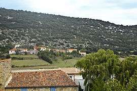
A general view of Fosse | ||
| ||
 Fosse | ||
|
Location within Occitanie region  Fosse | ||
| Coordinates: 42°47′21″N 2°25′55″E / 42.7892°N 2.4319°ECoordinates: 42°47′21″N 2°25′55″E / 42.7892°N 2.4319°E | ||
| Country | France | |
| Region | Occitanie | |
| Department | Pyrénées-Orientales | |
| Arrondissement | Perpignan | |
| Canton | Saint-Paul-de-Fenouillet | |
| Intercommunality | Agly Fenouillèdes | |
| Government | ||
| • Mayor (2014–2020) | Michel Garrigue | |
| Area1 | 4.43 km2 (1.71 sq mi) | |
| Population (2012)2 | 39 | |
| • Density | 8.8/km2 (23/sq mi) | |
| Time zone | CET (UTC+1) | |
| • Summer (DST) | CEST (UTC+2) | |
| INSEE/Postal code | 66083 / 66220 | |
| Elevation |
453–689 m (1,486–2,260 ft) (avg. 488 m or 1,601 ft) | |
|
1 French Land Register data, which excludes lakes, ponds, glaciers > 1 km² (0.386 sq mi or 247 acres) and river estuaries. 2 Population without double counting: residents of multiple communes (e.g., students and military personnel) only counted once. | ||
.svg.png)
Fosse is a commune in the Pyrénées-Orientales department in southern France.
Geography
Fosse is located in the canton of Saint-Paul-de-Fenouillet and in the arrondissement of Perpignan.
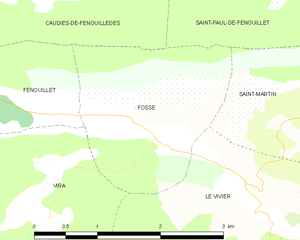
Map of Fosse and its surrounding communes
Government and politics
Mayors
| Mayor | Term start | Term end |
|---|---|---|
| Jean-Pierre Pellissier[1] | ca. 1803 | ? |
| Germain Pellissier[1] | before 1815 | ? (reelected in 1815) |
| A. Pélissier[1] | ca. 1937 | ? |
| Hervé Pagane | 2001 | 2008 |
| Michel Garrigue | 2008 |
Population
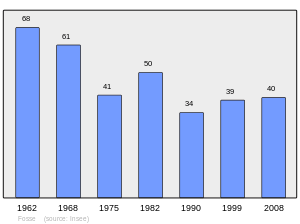
Population 1962-2008
See also
External links
References
| Wikimedia Commons has media related to Fosse (Pyrénées-Orientales). |
This article is issued from Wikipedia - version of the 2/21/2015. The text is available under the Creative Commons Attribution/Share Alike but additional terms may apply for the media files.