Saint-Laurent-de-Cerdans
| Saint-Laurent-de-Cerdans Sant Llorenç de Cerdans | |
|---|---|
|
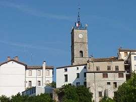
The village and its church | |
 Saint-Laurent-de-Cerdans | |
|
Location within Occitanie region  Saint-Laurent-de-Cerdans | |
| Coordinates: 42°23′12″N 2°36′50″E / 42.3867°N 2.6139°ECoordinates: 42°23′12″N 2°36′50″E / 42.3867°N 2.6139°E | |
| Country | France |
| Region | Occitanie |
| Department | Pyrénées-Orientales |
| Arrondissement | Céret |
| Canton | Prats-de-Mollo-la-Preste |
| Intercommunality | Haut Vallespir |
| Government | |
| • Mayor (2014-2020) | Louis Caseilles |
| Area1 | 45.08 km2 (17.41 sq mi) |
| Population (2006)2 | 1,299 |
| • Density | 29/km2 (75/sq mi) |
| Time zone | CET (UTC+1) |
| • Summer (DST) | CEST (UTC+2) |
| INSEE/Postal code | 66179 / 66260 |
| Elevation |
382–1,305 m (1,253–4,281 ft) (avg. 675 m or 2,215 ft) |
|
1 French Land Register data, which excludes lakes, ponds, glaciers > 1 km² (0.386 sq mi or 247 acres) and river estuaries. 2 Population without double counting: residents of multiple communes (e.g., students and military personnel) only counted once. | |
Saint-Laurent-de-Cerdans (Catalan: Sant Llorenç de Cerdans) is a commune in the Pyrénées-Orientales department in southern France.
Geography
Saint-Laurent-de-Cerdans is located in the canton of Prats-de-Mollo-la-Preste and in the arrondissement of Céret.
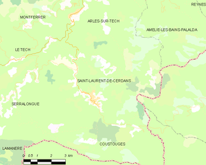
Map of Saint-Laurent-de-Cerdans and its surrounding communes
Government and politics
Mayors
| Mayor | Term start | Term end |
|---|---|---|
| Jacques Roitg | 2008 | 2014 |
| Louis Caseilles | 2014 |
Population
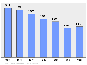
Population 1962-2008
See also
References
| Wikimedia Commons has media related to Saint-Laurent-de-Cerdans. |
This article is issued from Wikipedia - version of the 3/15/2016. The text is available under the Creative Commons Attribution/Share Alike but additional terms may apply for the media files.