Fontpédrouse
| Fontpédrouse Fontpedrosa | |
|---|---|
|
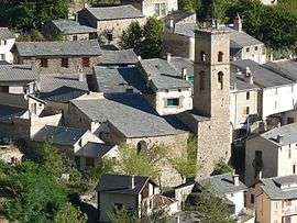
The church in Fontpédrouse | |
 Fontpédrouse | |
|
Location within Occitanie region  Fontpédrouse | |
| Coordinates: 42°30′46″N 2°10′51″E / 42.5128°N 2.1808°ECoordinates: 42°30′46″N 2°10′51″E / 42.5128°N 2.1808°E | |
| Country | France |
| Region | Occitanie |
| Department | Pyrénées-Orientales |
| Arrondissement | Prades |
| Canton | Mont-Louis |
| Government | |
| • Mayor (2008–2014) | Arlette Bigorre |
| Area1 | 64.35 km2 (24.85 sq mi) |
| Population (1999)2 | 123 |
| • Density | 1.9/km2 (5.0/sq mi) |
| Time zone | CET (UTC+1) |
| • Summer (DST) | CEST (UTC+2) |
| INSEE/Postal code | 66080 / 66360 |
| Elevation |
880–2,865 m (2,887–9,400 ft) (avg. 1,062 m or 3,484 ft) |
|
1 French Land Register data, which excludes lakes, ponds, glaciers > 1 km² (0.386 sq mi or 247 acres) and river estuaries. 2 Population without double counting: residents of multiple communes (e.g., students and military personnel) only counted once. | |
Fontpédrouse (Catalan: Fontpedrosa) is a commune in the Pyrénées-Orientales department in southern France.
Geography
Fontpédrouse is located in the canton of Mont-Louis and in the arrondissement of Prades.
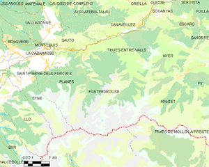
Map of Fontpédrouse and its surrounding communes
History
The commune of Prats-Saint-Thomas is merged into Fontpédrouse on 26 June 1822.[1]
Part of the hamlets of Prats-Saint-Thomas are destroyed in December 1932 because of heavy rains which caused several landslides.[2]
Population
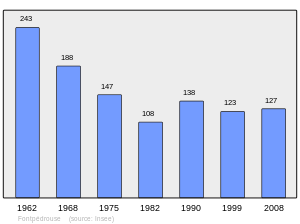
Population 1962-2008
See also
References
- ↑ (French) Jean-Pierre Pélissier, Paroisses et communes de France : dictionnaire d'histoire administrative et démographique, vol. 66 : Pyrénées-Orientales, Paris, CNRS, 1986
- ↑ (French) Fabricio Cardenas, Vieux papiers des Pyrénées-Orientales, Pluies diluviennes en décembre 1932, 3 february 2014
| Wikimedia Commons has media related to Fontpédrouse. |
This article is issued from Wikipedia - version of the 7/24/2016. The text is available under the Creative Commons Attribution/Share Alike but additional terms may apply for the media files.