Trévillach
| Trévillach Trevilhac | ||
|---|---|---|
|
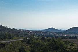
A general view of Trévillach | ||
| ||
 Trévillach | ||
|
Location within Occitanie region  Trévillach | ||
| Coordinates: 42°42′34″N 2°31′51″E / 42.7094°N 2.5308°ECoordinates: 42°42′34″N 2°31′51″E / 42.7094°N 2.5308°E | ||
| Country | France | |
| Region | Occitanie | |
| Department | Pyrénées-Orientales | |
| Arrondissement | Prades | |
| Canton | Sournia | |
| Intercommunality | Vinca-Canigou | |
| Government | ||
| • Mayor (2008–2012) | Marie-Thérèse Pignol | |
| Area1 | 17.24 km2 (6.66 sq mi) | |
| Population (2007)2 | 108 | |
| • Density | 6.3/km2 (16/sq mi) | |
| Time zone | CET (UTC+1) | |
| • Summer (DST) | CEST (UTC+2) | |
| INSEE/Postal code | 66215 / 66130 | |
| Elevation |
346–800 m (1,135–2,625 ft) (avg. 486 m or 1,594 ft) | |
|
1 French Land Register data, which excludes lakes, ponds, glaciers > 1 km² (0.386 sq mi or 247 acres) and river estuaries. 2 Population without double counting: residents of multiple communes (e.g., students and military personnel) only counted once. | ||
.svg.png)
Trévillach is a commune in the Pyrénées-Orientales department in southern France.
Geography
Localisation
Trévillach is located in the canton of Sournia and in the arrondissement of Prades.
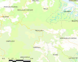
Map of Trévillach and its surrounding communes
Neighbouring communes
| Prats-de-Sournia | Pézilla-de-Conflent, Trilla | Caramany | |
| Sournia | |
Montalba-le-Château | |
| |||
| | |||
| Campoussy | Tarerach | Rodès |

Population and society
Demography
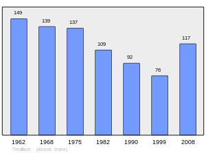
Population 1962–2008
Events
- Patronal feast : 11th of November.
- Communal feast : 22nd of August.
See also
References
External links
| Wikimedia Commons has media related to Trévillach. |
This article is issued from Wikipedia - version of the 6/14/2016. The text is available under the Creative Commons Attribution/Share Alike but additional terms may apply for the media files.