Corbère
| Corbère Corbera del Castell | ||
|---|---|---|
|
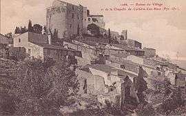
Corbère-d'en-Haut in the early 20th century | ||
| ||
 Corbère | ||
|
Location within Occitanie region  Corbère | ||
| Coordinates: 42°39′14″N 2°39′41″E / 42.6539°N 2.6614°ECoordinates: 42°39′14″N 2°39′41″E / 42.6539°N 2.6614°E | ||
| Country | France | |
| Region | Occitanie | |
| Department | Pyrénées-Orientales | |
| Arrondissement | Perpignan | |
| Canton | La Vallée de la Têt | |
| Intercommunality | Roussillon Conflent | |
| Government | ||
| • Mayor (2014–2020) | Joseph Silvestre | |
| Area1 | 7.25 km2 (2.80 sq mi) | |
| Population (2013)2 | 721 | |
| • Density | 99/km2 (260/sq mi) | |
| Time zone | CET (UTC+1) | |
| • Summer (DST) | CEST (UTC+2) | |
| INSEE/Postal code | 66055 / 66130 | |
| Elevation |
130–523 m (427–1,716 ft) (avg. 160 m or 520 ft) | |
|
1 French Land Register data, which excludes lakes, ponds, glaciers > 1 km² (0.386 sq mi or 247 acres) and river estuaries. 2 Population without double counting: residents of multiple communes (e.g., students and military personnel) only counted once. | ||

Corbère (Catalan: Corbera del Castell) is a commune in the Pyrénées-Orientales department in southern France.
Geography
Corbère is located in the canton of Millas and in the arrondissement of Perpignan.
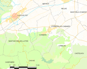
Map of Corbère and its surrounding communes
Population
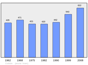
Population 1962-2008
See also
References
| Wikimedia Commons has media related to Corbère. |
This article is issued from Wikipedia - version of the 9/28/2016. The text is available under the Creative Commons Attribution/Share Alike but additional terms may apply for the media files.