Campoussy
| Campoussy | ||
|---|---|---|
|
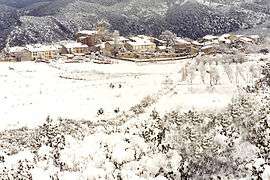
Campoussy in the snow | ||
| ||
 Campoussy | ||
|
Location within Occitanie region  Campoussy | ||
| Coordinates: 42°42′40″N 2°27′33″E / 42.7111°N 2.4592°ECoordinates: 42°42′40″N 2°27′33″E / 42.7111°N 2.4592°E | ||
| Country | France | |
| Region | Occitanie | |
| Department | Pyrénées-Orientales | |
| Arrondissement | Prades | |
| Canton | Vallée de l'Agly | |
| Intercommunality | Conflent | |
| Government | ||
| • Mayor (2014-2020) | Alain Boyer | |
| Area1 | 17.04 km2 (6.58 sq mi) | |
| Population (2013)2 | 44 | |
| • Density | 2.6/km2 (6.7/sq mi) | |
| Time zone | CET (UTC+1) | |
| • Summer (DST) | CEST (UTC+2) | |
| INSEE/Postal code | 66035 / 66730 | |
| Elevation | 391–1,144 m (1,283–3,753 ft) | |
|
1 French Land Register data, which excludes lakes, ponds, glaciers > 1 km² (0.386 sq mi or 247 acres) and river estuaries. 2 Population without double counting: residents of multiple communes (e.g., students and military personnel) only counted once. | ||
.svg.png)
Campoussy is a commune located in the Pyrénées-Orientales department, in southern France.
Geography
Localisation
Campoussy is located in the canton of Sournia and in the arrondissement of Prades.
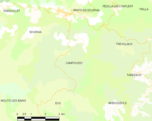
Map of Campoussy and its surrounding communes
Neighbouring communes
| Sournia | Trévillach | ||
| |
Tarerach | ||
| |||
| | |||
| Eus | Arboussols |

Population
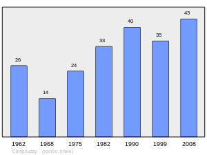
Population 1962-2008
See also
References
| Wikimedia Commons has media related to Campoussy. |
This article is issued from Wikipedia - version of the 6/15/2016. The text is available under the Creative Commons Attribution/Share Alike but additional terms may apply for the media files.