Saint-Nazaire, Pyrénées-Orientales
| Saint-Nazaire | |
|---|---|
|
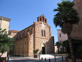
The chapel of Notre-Dame de l'Arca, in Saint-Nazaire | |
 Saint-Nazaire | |
|
Location within Occitanie region  Saint-Nazaire | |
| Coordinates: 42°40′07″N 2°59′33″E / 42.6686°N 2.9925°ECoordinates: 42°40′07″N 2°59′33″E / 42.6686°N 2.9925°E | |
| Country | France |
| Region | Occitanie |
| Department | Pyrénées-Orientales |
| Arrondissement | Perpignan |
| Canton | Canet-en-Roussillon |
| Intercommunality | Perpignan Méditerranée |
| Government | |
| • Mayor (2008–2014) | Jean-Claude Torrens (PR) |
| Area1 | 10.33 km2 (3.99 sq mi) |
| Population (2006)2 | 2,319 |
| • Density | 220/km2 (580/sq mi) |
| Time zone | CET (UTC+1) |
| • Summer (DST) | CEST (UTC+2) |
| INSEE/Postal code | 66186 / 66570 |
| Elevation |
0–18 m (0–59 ft) (avg. 6 m or 20 ft) |
|
1 French Land Register data, which excludes lakes, ponds, glaciers > 1 km² (0.386 sq mi or 247 acres) and river estuaries. 2 Population without double counting: residents of multiple communes (e.g., students and military personnel) only counted once. | |
Saint-Nazaire (Catalan: Sant Nazari de Rosselló) is a commune in the Pyrénées-Orientales department in southern France.
Geography
Saint-Nazaire is located in the canton of Canet-en-Roussillon and in the arrondissement of Perpignan.
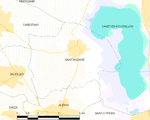
Map of Saint-Nazaire and its surrounding communes
Population

Population 1962-2008
See also
References
| Wikimedia Commons has media related to Saint-Nazaire (Pyrénées-Orientales). |
This article is issued from Wikipedia - version of the 3/15/2016. The text is available under the Creative Commons Attribution/Share Alike but additional terms may apply for the media files.