Montesquieu-des-Albères
| Montesquieu-des-Albères Montesquiu d'Albera | ||
|---|---|---|
|
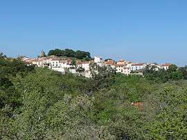
A general view of the village and castle of Montesquieu-des-Albères | ||
| ||
 Montesquieu-des-Albères | ||
|
Location within Occitanie region  Montesquieu-des-Albères | ||
| Coordinates: 42°31′05″N 2°52′56″E / 42.5181°N 2.8822°ECoordinates: 42°31′05″N 2°52′56″E / 42.5181°N 2.8822°E | ||
| Country | France | |
| Region | Occitanie | |
| Department | Pyrénées-Orientales | |
| Arrondissement | Céret | |
| Canton | Argelès-sur-Mer | |
| Intercommunality | Albères | |
| Government | ||
| • Mayor (2008–2014) | Huguette Schuler-Pons | |
| Area1 | 17.06 km2 (6.59 sq mi) | |
| Population (1999)2 | 824 | |
| • Density | 48/km2 (130/sq mi) | |
| Time zone | CET (UTC+1) | |
| • Summer (DST) | CEST (UTC+2) | |
| INSEE/Postal code | 66115 / 66740 | |
| Elevation |
43–1,001 m (141–3,284 ft) (avg. 250 m or 820 ft) | |
|
1 French Land Register data, which excludes lakes, ponds, glaciers > 1 km² (0.386 sq mi or 247 acres) and river estuaries. 2 Population without double counting: residents of multiple communes (e.g., students and military personnel) only counted once. | ||

Montesquieu-des-Albères (Catalan: Montesquiu d'Albera) is a commune in the Pyrénées-Orientales department in southern France.
Geography
Montesquieu-des-Albères is located in the canton of Argelès-sur-Mer and in the arrondissement of Céret.
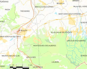
Map of Montesquieu-des-Albères and its surrounding communes
Population
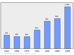
Population 1962-2008
Sites of interest
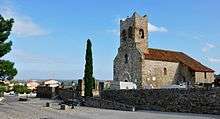
Romanesque church Saint-Saturnin de Montesquieu-des-Albères, 12th ctry.
.jpg)
The medieval castle
- Church of Saint-Saturnin
- Church of Saint-Christopher
- Castle, 11th ctry.
See also
References
| Wikimedia Commons has media related to Montesquieu-des-Albères. |
This article is issued from Wikipedia - version of the 3/26/2016. The text is available under the Creative Commons Attribution/Share Alike but additional terms may apply for the media files.