Saint-Michel-de-Llotes
| Saint-Michel-de-Llotes | |
|---|---|
|
The town hall in Saint-Michel-de-Llotes | |
 Saint-Michel-de-Llotes | |
|
Location within Occitanie region  Saint-Michel-de-Llotes | |
| Coordinates: 42°39′00″N 2°37′29″E / 42.65°N 2.6247°ECoordinates: 42°39′00″N 2°37′29″E / 42.65°N 2.6247°E | |
| Country | France |
| Region | Occitanie |
| Department | Pyrénées-Orientales |
| Arrondissement | Prades |
| Canton | Vinça |
| Intercommunality | Roussillon Conflent |
| Government | |
| • Mayor (2001–2008) | Guy Noou |
| Area1 | 8.64 km2 (3.34 sq mi) |
| Population (1999)2 | 269 |
| • Density | 31/km2 (81/sq mi) |
| Time zone | CET (UTC+1) |
| • Summer (DST) | CEST (UTC+2) |
| INSEE/Postal code | 66185 / 66130 |
| Elevation |
146–602 m (479–1,975 ft) (avg. 187 m or 614 ft) |
|
1 French Land Register data, which excludes lakes, ponds, glaciers > 1 km² (0.386 sq mi or 247 acres) and river estuaries. 2 Population without double counting: residents of multiple communes (e.g., students and military personnel) only counted once. | |
.jpg)
Saint-Michel-de-Llotes (Catalan: Sant Miquel de Llotes) is a commune in the Pyrénées-Orientales department in southern France.
Geography
Saint-Michel-de-Llotes is located in the canton of Vinça and in the arrondissement of Prades.
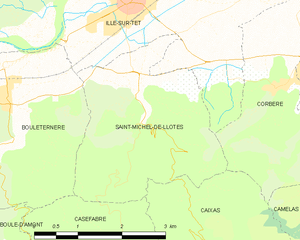
Map of Saint-Michel-de-Llotes and its surrounding communes
Population
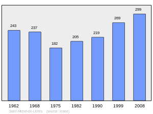
Population 1962-2008
See also
References
| Wikimedia Commons has media related to Saint-Michel-de-Llotes. |
This article is issued from Wikipedia - version of the 2/7/2016. The text is available under the Creative Commons Attribution/Share Alike but additional terms may apply for the media files.