Saint-Hippolyte, Pyrénées-Orientales
| Saint-Hippolyte | ||
|---|---|---|
|
The church in Saint-Hippolyte | ||
| ||
 Saint-Hippolyte | ||
|
Location within Occitanie region  Saint-Hippolyte | ||
| Coordinates: 42°47′06″N 2°58′02″E / 42.785°N 2.9672°ECoordinates: 42°47′06″N 2°58′02″E / 42.785°N 2.9672°E | ||
| Country | France | |
| Region | Occitanie | |
| Department | Pyrénées-Orientales | |
| Arrondissement | Perpignan | |
| Canton | La Côte Salanquaise | |
| Intercommunality | Perpignan Méditerranée | |
| Government | ||
| • Mayor (2014-2020) | Madeleine Garcia-Vidal | |
| Area1 | 14.65 km2 (5.66 sq mi) | |
| Population (1999)2 | 1,849 | |
| • Density | 130/km2 (330/sq mi) | |
| Time zone | CET (UTC+1) | |
| • Summer (DST) | CEST (UTC+2) | |
| INSEE/Postal code | 66176 / 66510 | |
| Elevation |
0–11 m (0–36 ft) (avg. 6 m or 20 ft) | |
|
1 French Land Register data, which excludes lakes, ponds, glaciers > 1 km² (0.386 sq mi or 247 acres) and river estuaries. 2 Population without double counting: residents of multiple communes (e.g., students and military personnel) only counted once. | ||


Saint-Hippolyte (Catalan: Sant Hipòlit de la Salanca) is a commune in the Pyrénées-Orientales department in southern France.
Geography
Saint-Hippolyte is located in the canton of Saint-Laurent-de-la-Salanque and in the arrondissement of Perpignan.
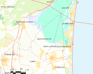
Map of Saint-Hippolyte and its surrounding communes
Government and politics

Signature of mayor Étienne Masnou in 1815
Mayors
| Mayor | Term start | Term end |
|---|---|---|
| Étienne Masnou[1] | ? | June 1815 |
| Pierre Gari[1] | June 1815 | ? |
| Michel Montagne | 2001 | 2014 |
| Madeleine Garcia-Vidal | 2014 |
Population
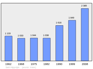
Population 1962-2008
See also
References
- 1 2 (French) Fabricio Cardenas, Vieux papiers des Pyrénées-Orientales, Saint-Hippolyte, le 31 mai 1815, 25 january 2014
| Wikimedia Commons has media related to Saint-Hippolyte (Pyrénées-Orientales). |
This article is issued from Wikipedia - version of the 10/21/2016. The text is available under the Creative Commons Attribution/Share Alike but additional terms may apply for the media files.