Saint-Jean-Pla-de-Corts
| Saint-Jean-Pla-de-Corts | |
|---|---|
|
Guy Malé Square, in Saint-Jean-Pla-de-Corts | |
 Saint-Jean-Pla-de-Corts | |
|
Location within Occitanie region  Saint-Jean-Pla-de-Corts | |
| Coordinates: 42°30′43″N 2°47′34″E / 42.5119°N 2.7928°ECoordinates: 42°30′43″N 2°47′34″E / 42.5119°N 2.7928°E | |
| Country | France |
| Region | Occitanie |
| Department | Pyrénées-Orientales |
| Arrondissement | Céret |
| Canton | Céret |
| Intercommunality | Vallespir |
| Government | |
| • Mayor (2008–2014) | Robert Garrabe |
| Area1 | 10.62 km2 (4.10 sq mi) |
| Population (1999)2 | 1,775 |
| • Density | 170/km2 (430/sq mi) |
| Time zone | CET (UTC+1) |
| • Summer (DST) | CEST (UTC+2) |
| INSEE/Postal code | 66178 / 66490 |
| Elevation |
71–208 m (233–682 ft) (avg. 116 m or 381 ft) |
|
1 French Land Register data, which excludes lakes, ponds, glaciers > 1 km² (0.386 sq mi or 247 acres) and river estuaries. 2 Population without double counting: residents of multiple communes (e.g., students and military personnel) only counted once. | |

Saint-Jean-Pla-de-Corts (Catalan: Sant Joan de Pladecorts) is a commune in the Pyrénées-Orientales department in southern France.
Geography
Saint-Jean-Pla-de-Corts is located in the canton of Céret and in the arrondissement of Céret.
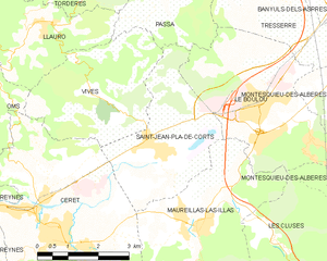
Map of Saint-Jean-Pla-de-Corts and its surrounding communes
Population
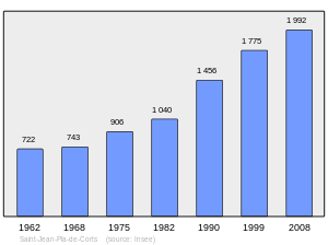
Population 1962-2008
See also
References
| Wikimedia Commons has media related to Saint-Jean-Pla-de-Corts. |
This article is issued from Wikipedia - version of the 2/11/2016. The text is available under the Creative Commons Attribution/Share Alike but additional terms may apply for the media files.