Castelnou, Pyrénées-Orientales
| Castelnou | ||
|---|---|---|
|
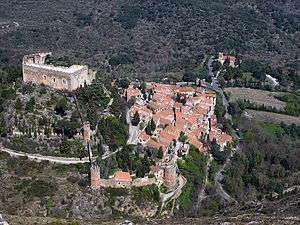
View of Castelnou and its castle | ||
| ||
 Castelnou | ||
|
Location within Occitanie region  Castelnou | ||
| Coordinates: 42°37′14″N 2°42′11″E / 42.6206°N 2.7031°ECoordinates: 42°37′14″N 2°42′11″E / 42.6206°N 2.7031°E | ||
| Country | France | |
| Region | Occitanie | |
| Department | Pyrénées-Orientales | |
| Arrondissement | Perpignan | |
| Canton | Les Aspres | |
| Intercommunality | Aspres | |
| Government | ||
| • Mayor (2014-2020) | Jean Cherez | |
| Area1 | 19.28 km2 (7.44 sq mi) | |
| Population (2013)2 | 341 | |
| • Density | 18/km2 (46/sq mi) | |
| Time zone | CET (UTC+1) | |
| • Summer (DST) | CEST (UTC+2) | |
| INSEE/Postal code | 66044 / 66300 | |
| Elevation | 111–444 m (364–1,457 ft) | |
|
1 French Land Register data, which excludes lakes, ponds, glaciers > 1 km² (0.386 sq mi or 247 acres) and river estuaries. 2 Population without double counting: residents of multiple communes (e.g., students and military personnel) only counted once. | ||
.svg.png)
Castelnou (Catalan: Castellnou dels Aspres) is a commune in the Pyrénées-Orientales department in southern France.
Geography
Castelnou is located in the canton of Thuir and in the arrondissement of Perpignan.
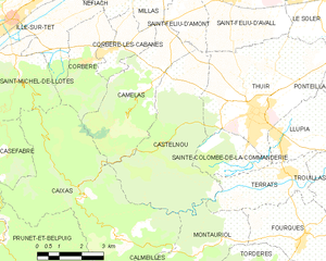
Map of Castelnou and its surrounding communes
Population
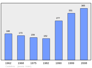
Population 1962-2008
Sites of interest
- Château de Castelnou : the medieval castle.
- The old village, labelled as Plus Beaux Villages de France.
- The church of Sainte-Marie du Mercadal, from the 13th century.
- The tower of Castelnou, a former watch tower.
Gallery
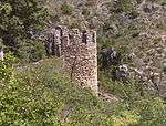 A tower of the castle
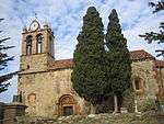 The church of Sainte-Marie du Mercadal
 A street in the village
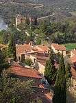 The village seen from the castle
See also
References
| Wikimedia Commons has media related to Castelnou, Pyrénées-Orientales. |
This article is issued from Wikipedia - version of the 5/7/2016. The text is available under the Creative Commons Attribution/Share Alike but additional terms may apply for the media files.