Porta, Pyrénées-Orientales
| Porta | |
|---|---|
|
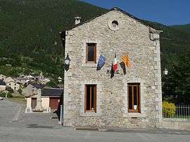
The town hall in Porta | |
 Porta | |
|
Location within Occitanie region  Porta | |
| Coordinates: 42°31′38″N 1°49′36″E / 42.5272°N 1.8267°ECoordinates: 42°31′38″N 1°49′36″E / 42.5272°N 1.8267°E | |
| Country | France |
| Region | Occitanie |
| Department | Pyrénées-Orientales |
| Arrondissement | Prades |
| Canton | Saillagouse |
| Government | |
| • Mayor (2008–) | Suzanne Delieux |
| Area1 | 65.19 km2 (25.17 sq mi) |
| Population (2006)2 | 130 |
| • Density | 2.0/km2 (5.2/sq mi) |
| Time zone | CET (UTC+1) |
| • Summer (DST) | CEST (UTC+2) |
| INSEE/Postal code | 66146 / 66760 |
| Elevation |
1,325–2,907 m (4,347–9,537 ft) (avg. 1,510 m or 4,950 ft) |
|
1 French Land Register data, which excludes lakes, ponds, glaciers > 1 km² (0.386 sq mi or 247 acres) and river estuaries. 2 Population without double counting: residents of multiple communes (e.g., students and military personnel) only counted once. | |
Porta is a commune in the Pyrénées-Orientales department in southern France.
Geography
Porta is located in the canton of Saillagouse and in the arrondissement of Prades.

Map of Porta and its surrounding communes
Population
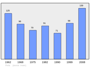
Population 1962-2008
See also
External links
- Official web from Porta
References
| Wikimedia Commons has media related to Porta. |
This article is issued from Wikipedia - version of the 1/11/2016. The text is available under the Creative Commons Attribution/Share Alike but additional terms may apply for the media files.