Eus
For other uses, see EUS.
| Eus | ||
|---|---|---|
|
A general view of Eus | ||
| ||
 Eus | ||
|
Location within Occitanie region  Eus | ||
| Coordinates: 42°38′40″N 2°27′29″E / 42.6444°N 2.4581°ECoordinates: 42°38′40″N 2°27′29″E / 42.6444°N 2.4581°E | ||
| Country | France | |
| Region | Occitanie | |
| Department | Pyrénées-Orientales | |
| Arrondissement | Prades | |
| Canton | Prades | |
| Government | ||
| • Mayor (2001–2008) | André Brugat | |
| Area1 | 20.08 km2 (7.75 sq mi) | |
| Population (2006)2 | 411 | |
| • Density | 20/km2 (53/sq mi) | |
| Time zone | CET (UTC+1) | |
| • Summer (DST) | CEST (UTC+2) | |
| INSEE/Postal code | 66074 / 66500 | |
| Elevation |
244–1,143 m (801–3,750 ft) (avg. 349 m or 1,145 ft) | |
|
1 French Land Register data, which excludes lakes, ponds, glaciers > 1 km² (0.386 sq mi or 247 acres) and river estuaries. 2 Population without double counting: residents of multiple communes (e.g., students and military personnel) only counted once. | ||
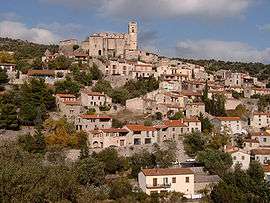

Eus is a commune in the Pyrénées-Orientales department in southern France.
Geography
Eus is located in the canton of Prades and in the arrondissement of Prades.
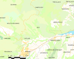
Map of Eus and its surrounding communes
Population
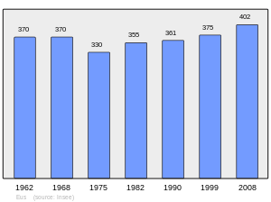
Population 1962-2008
See also
References
| Wikimedia Commons has media related to Eus. |
This article is issued from Wikipedia - version of the 11/3/2015. The text is available under the Creative Commons Attribution/Share Alike but additional terms may apply for the media files.