Vingrau
| Vingrau | |
|---|---|
|
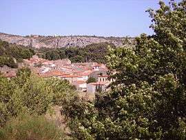
A general view of Vingrau | |
 Vingrau | |
|
Location within Occitanie region  Vingrau | |
| Coordinates: 42°50′56″N 2°46′45″E / 42.8489°N 2.7792°ECoordinates: 42°50′56″N 2°46′45″E / 42.8489°N 2.7792°E | |
| Country | France |
| Region | Occitanie |
| Department | Pyrénées-Orientales |
| Arrondissement | Perpignan |
| Canton | Rivesaltes |
| Intercommunality | Communauté d'agglomération Perpignan Méditerranée |
| Government | |
| • Mayor (2014-2020) | Philippe Camps |
| Area1 | 32.12 km2 (12.40 sq mi) |
| Population (2012)2 | 644 |
| • Density | 20/km2 (52/sq mi) |
| Time zone | CET (UTC+1) |
| • Summer (DST) | CEST (UTC+2) |
| INSEE/Postal code | 66231 / 66600 |
| Elevation |
119–575 m (390–1,886 ft) (avg. 322 m or 1,056 ft) |
|
1 French Land Register data, which excludes lakes, ponds, glaciers > 1 km² (0.386 sq mi or 247 acres) and river estuaries. 2 Population without double counting: residents of multiple communes (e.g., students and military personnel) only counted once. | |
Vingrau is a commune in the Pyrénées-Orientales department in southern France.
Geography
Vingrau is located in the canton of Rivesaltes and in the arrondissement of Perpignan.
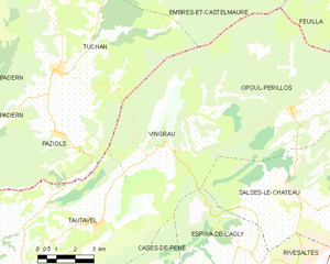
Map of Vingrau and its surrounding communes
History
The townhall of Vingrau is destroyed by a fire in 1935, with all the municipal archives, and causing the death of a local roadman.[1]
Population
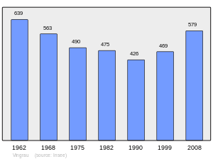
Population 1962-2008
See also
References
- ↑ (French) Fabricio Cardenas, Vieux papiers des Pyrénées-Orientales, Incendie de la mairie de Vingrau en 1935, 6 march 2014
| Wikimedia Commons has media related to Vingrau. |
This article is issued from Wikipedia - version of the 2/15/2016. The text is available under the Creative Commons Attribution/Share Alike but additional terms may apply for the media files.