Brouilla
| Brouilla | |
|---|---|
|
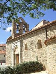
The church of Sainte-Marie, in Brouilla | |
 Brouilla | |
|
Location within Occitanie region  Brouilla | |
| Coordinates: 42°34′03″N 2°54′16″E / 42.5675°N 2.9044°ECoordinates: 42°34′03″N 2°54′16″E / 42.5675°N 2.9044°E | |
| Country | France |
| Region | Occitanie |
| Department | Pyrénées-Orientales |
| Arrondissement | Perpignan |
| Canton | Thuir |
| Intercommunality | Aspres |
| Government | |
| • Mayor (2014–2020) | Pierre Taurinya |
| Area1 | 7.83 km2 (3.02 sq mi) |
| Population (2012)2 | 1,155 |
| • Density | 150/km2 (380/sq mi) |
| Time zone | CET (UTC+1) |
| • Summer (DST) | CEST (UTC+2) |
| INSEE/Postal code | 66026 / 66620 |
| Elevation |
27–108 m (89–354 ft) (avg. 46 m or 151 ft) |
|
1 French Land Register data, which excludes lakes, ponds, glaciers > 1 km² (0.386 sq mi or 247 acres) and river estuaries. 2 Population without double counting: residents of multiple communes (e.g., students and military personnel) only counted once. | |
Brouilla (Catalan: Brullà) is a commune in the Pyrénées-Orientales department in southern France.
Geography
Localisation
Brouilla is located in the canton of Thuir and in the arrondissement of Perpignan.
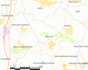
Map of Brouilla and its surrounding communes
Neighbouring communes
| Villemolaque (by a quadripoint) | Bages | ||
| Saint-Jean-Lasseille | |
Ortaffa | |
| |||
| | |||
| Banyuls-dels-Aspres | Villelongue-dels-Monts | Saint-Génis-des-Fontaines |

Government and politics
Mayors
| Mayor | Term start | Term end |
|---|---|---|
| François Nègre | 1959 | 1971 |
| Michel Capdet | 1971 | 1991 |
| Roger Parada | 1991 | 1995 |
| Pierre Taurinya | 1995 |
Population
| Historical population | ||
|---|---|---|
| Year | Pop. | ±% |
| 1962 | 530 | — |
| 1968 | 537 | +1.3% |
| 1975 | 564 | +5.0% |
| 1982 | 616 | +9.2% |
| 1990 | 565 | −8.3% |
| 1999 | 630 | +11.5% |
| 2007 | 990 | +57.1% |
| 2009 | 1,037 | +4.7% |
See also
References
| Wikimedia Commons has media related to Brouilla. |
This article is issued from Wikipedia - version of the 9/28/2016. The text is available under the Creative Commons Attribution/Share Alike but additional terms may apply for the media files.