Espira-de-l'Agly
| Espira-de-l'Agly Espirà de l'Aglí | ||
|---|---|---|
|
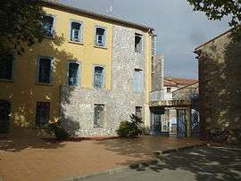
The town hall in Espira-de-l'Agly | ||
| ||
 Espira-de-l'Agly | ||
|
Location within Occitanie region  Espira-de-l'Agly | ||
| Coordinates: 42°46′41″N 2°50′11″E / 42.7781°N 2.8364°ECoordinates: 42°46′41″N 2°50′11″E / 42.7781°N 2.8364°E | ||
| Country | France | |
| Region | Occitanie | |
| Department | Pyrénées-Orientales | |
| Arrondissement | Perpignan | |
| Canton | Rivesaltes | |
| Intercommunality | Rivesaltais - Agly - Manadeil | |
| Government | ||
| • Mayor (2008–2014) | Gérard Bile | |
| Area1 | 26.77 km2 (10.34 sq mi) | |
| Population (2005)2 | 2,850 | |
| • Density | 110/km2 (280/sq mi) | |
| Time zone | CET (UTC+1) | |
| • Summer (DST) | CEST (UTC+2) | |
| INSEE/Postal code | 66069 / 66600 | |
| Elevation |
26–458 m (85–1,503 ft) (avg. 36 m or 118 ft) | |
|
1 French Land Register data, which excludes lakes, ponds, glaciers > 1 km² (0.386 sq mi or 247 acres) and river estuaries. 2 Population without double counting: residents of multiple communes (e.g., students and military personnel) only counted once. | ||

Espira-de-l'Agly (Catalan: Espirà de l'Aglí) is a commune in the Pyrénées-Orientales department in southern France.
Geography
Espira-de-l'Agly is located in the canton of Rivesaltes and in the arrondissement of Perpignan.
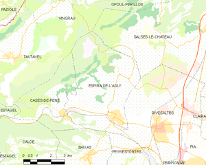
Map of Espira-de-l'Agly and its surrounding communes
Espira-de-l'Agly is situated approximately 12 km outside Perpignan.
Population
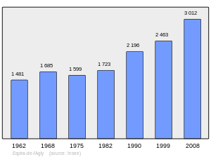
Population 1962-2008
See also
References
| Wikimedia Commons has media related to Espira-de-l'Agly. |
This article is issued from Wikipedia - version of the 2/12/2016. The text is available under the Creative Commons Attribution/Share Alike but additional terms may apply for the media files.