Saint-Féliu-d'Amont
| Saint-Féliu-d'Amont Sant Feliu d'Amunt | ||
|---|---|---|
|
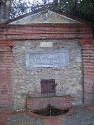
The fountain of Sainte-Apollonie, in Saint-Féliu-d'Amont | ||
| ||
 Saint-Féliu-d'Amont | ||
|
Location within Occitanie region  Saint-Féliu-d'Amont | ||
| Coordinates: 42°41′14″N 2°43′23″E / 42.6872°N 2.7231°ECoordinates: 42°41′14″N 2°43′23″E / 42.6872°N 2.7231°E | ||
| Country | France | |
| Region | Occitanie | |
| Department | Pyrénées-Orientales | |
| Arrondissement | Perpignan | |
| Canton | Millas | |
| Intercommunality | Roussillon Conflent | |
| Government | ||
| • Mayor (2008–2014) | Robert Olive | |
| Area1 | 6.11 km2 (2.36 sq mi) | |
| Population (1999)2 | 654 | |
| • Density | 110/km2 (280/sq mi) | |
| Time zone | CET (UTC+1) | |
| • Summer (DST) | CEST (UTC+2) | |
| INSEE/Postal code | 66173 / 66170 | |
| Elevation |
82–124 m (269–407 ft) (avg. 82 m or 269 ft) | |
|
1 French Land Register data, which excludes lakes, ponds, glaciers > 1 km² (0.386 sq mi or 247 acres) and river estuaries. 2 Population without double counting: residents of multiple communes (e.g., students and military personnel) only counted once. | ||

Saint-Féliu-d'Amont (Catalan: Sant Feliu d'Amunt) is a commune in the Pyrénées-Orientales department in southern France.
Geography
Saint-Féliu-d'Amont is in the canton of Millas and in the arrondissement of Perpignan.

Map of Saint-Féliu-d'Amont and its surrounding communes
Population
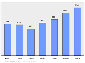
Population 1962-2008
Notable people
- Christian Bourquin (1954-) : politician born in Saint-Féliu-d'Amont.
See also
References
| Wikimedia Commons has media related to Saint-Féliu-d'Amont. |
This article is issued from Wikipedia - version of the 2/3/2016. The text is available under the Creative Commons Attribution/Share Alike but additional terms may apply for the media files.