Boisyvon
| Boisyvon | |
|---|---|
|
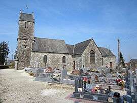
The church of Saint-Pierre | |
 Boisyvon | |
|
Location within Normandy region  Boisyvon | |
| Coordinates: 48°48′23″N 1°07′40″W / 48.8064°N 1.1278°WCoordinates: 48°48′23″N 1°07′40″W / 48.8064°N 1.1278°W | |
| Country | France |
| Region | Normandy |
| Department | Manche |
| Arrondissement | Avranches |
| Canton | Saint-Pois |
| Intercommunality | Canton de Saint-Pois |
| Government | |
| • Mayor (2008–2014) | Stéphane Primois |
| Area1 | 3.85 km2 (1.49 sq mi) |
| Population (2009)2 | 112 |
| • Density | 29/km2 (75/sq mi) |
| Time zone | CET (UTC+1) |
| • Summer (DST) | CEST (UTC+2) |
| INSEE/Postal code | 50062 / 50800 |
| Elevation |
170–270 m (560–890 ft) (avg. 250 m or 820 ft) |
|
1 French Land Register data, which excludes lakes, ponds, glaciers > 1 km² (0.386 sq mi or 247 acres) and river estuaries. 2 Population without double counting: residents of multiple communes (e.g., students and military personnel) only counted once. | |
Boisyvon is a commune in the Manche department in Normandy in northwestern France.
Population
| Historical population | ||
|---|---|---|
| Year | Pop. | ±% |
| 1793 | 260 | — |
| 1800 | 248 | −4.6% |
| 1806 | 316 | +27.4% |
| 1821 | 250 | −20.9% |
| 1831 | 280 | +12.0% |
| 1836 | 292 | +4.3% |
| 1841 | 310 | +6.2% |
| 1846 | 310 | +0.0% |
| 1851 | 317 | +2.3% |
| 1856 | 285 | −10.1% |
| 1861 | 280 | −1.8% |
| 1866 | 277 | −1.1% |
| 1872 | 267 | −3.6% |
| 1876 | 254 | −4.9% |
| 1881 | 237 | −6.7% |
| 1886 | 247 | +4.2% |
| 1891 | 221 | −10.5% |
| 1896 | 217 | −1.8% |
| 1901 | 226 | +4.1% |
| 1906 | 231 | +2.2% |
| 1911 | 213 | −7.8% |
| 1921 | 198 | −7.0% |
| 1926 | 173 | −12.6% |
| 1931 | 191 | +10.4% |
| 1936 | 215 | +12.6% |
| 1946 | 176 | −18.1% |
| 1954 | 191 | +8.5% |
| 1962 | 162 | −15.2% |
| 1968 | 152 | −6.2% |
| 1975 | 142 | −6.6% |
| 1982 | 116 | −18.3% |
| 1990 | 105 | −9.5% |
| 1999 | 106 | +1.0% |
| 2009 | 112 | +5.7% |
See also
References
| Wikimedia Commons has media related to Boisyvon. |
This article is issued from Wikipedia - version of the 8/16/2016. The text is available under the Creative Commons Attribution/Share Alike but additional terms may apply for the media files.