Pont-Hébert
| Pont-Hébert | |
|---|---|
|
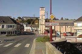
Pont-Hébert viewed from the bridge over the Vire | |
 Pont-Hébert | |
|
Location within Normandy region  Pont-Hébert | |
| Coordinates: 49°10′04″N 1°07′55″W / 49.1678°N 1.1319°WCoordinates: 49°10′04″N 1°07′55″W / 49.1678°N 1.1319°W | |
| Country | France |
| Region | Normandy |
| Department | Manche |
| Arrondissement | Saint-Lô |
| Canton | Saint-Jean-de-Daye |
| Intercommunality | Communauté de communes de l'agglomération saint-loise |
| Government | |
| • Mayor (2008–2014) | Lucien Boëm |
| Area1 | 14.99 km2 (5.79 sq mi) |
| Population (2006)2 | 1,771 |
| • Density | 120/km2 (310/sq mi) |
| Time zone | CET (UTC+1) |
| • Summer (DST) | CEST (UTC+2) |
| INSEE/Postal code | 50409 / 50880 |
| Elevation |
5–83 m (16–272 ft) (avg. 49 m or 161 ft) |
|
1 French Land Register data, which excludes lakes, ponds, glaciers > 1 km² (0.386 sq mi or 247 acres) and river estuaries. 2 Population without double counting: residents of multiple communes (e.g., students and military personnel) only counted once. | |
Pont-Hébert is a commune in the Manche department in Normandy in north-western France.
See also
| Wikimedia Commons has media related to Pont-Hébert. |
This article is issued from Wikipedia - version of the 2/27/2015. The text is available under the Creative Commons Attribution/Share Alike but additional terms may apply for the media files.