Benoîtville
| Benoîtville | |
|---|---|
|
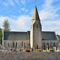
The church of_Saint-Pierre | |
 Benoîtville | |
|
Location within Normandy region  Benoîtville | |
| Coordinates: 49°31′43″N 1°46′45″W / 49.5286°N 1.7792°WCoordinates: 49°31′43″N 1°46′45″W / 49.5286°N 1.7792°W | |
| Country | France |
| Region | Normandy |
| Department | Manche |
| Arrondissement | Cherbourg-Octeville |
| Canton | Les Pieux |
| Intercommunality | Pieux |
| Government | |
| • Mayor (2008–2014) | Daniel Gancel |
| Area1 | 8.29 km2 (3.20 sq mi) |
| Population (2009)2 | 571 |
| • Density | 69/km2 (180/sq mi) |
| Time zone | CET (UTC+1) |
| • Summer (DST) | CEST (UTC+2) |
| INSEE/Postal code | 50045 / 50340 |
| Elevation |
35–131 m (115–430 ft) (avg. 50 m or 160 ft) |
|
1 French Land Register data, which excludes lakes, ponds, glaciers > 1 km² (0.386 sq mi or 247 acres) and river estuaries. 2 Population without double counting: residents of multiple communes (e.g., students and military personnel) only counted once. | |
Benoîtville is a commune in the Manche department in the Basse-Normandie region in northwestern France.
Population
| Historical population | ||
|---|---|---|
| Year | Pop. | ±% |
| 1793 | 650 | — |
| 1800 | 552 | −15.1% |
| 1806 | 613 | +11.1% |
| 1821 | 614 | +0.2% |
| 1831 | 615 | +0.2% |
| 1836 | 652 | +6.0% |
| 1841 | 667 | +2.3% |
| 1846 | 660 | −1.0% |
| 1851 | 646 | −2.1% |
| 1856 | 602 | −6.8% |
| 1861 | 570 | −5.3% |
| 1866 | 555 | −2.6% |
| 1872 | 522 | −5.9% |
| 1876 | 507 | −2.9% |
| 1881 | 511 | +0.8% |
| 1886 | 502 | −1.8% |
| 1891 | 462 | −8.0% |
| 1896 | 441 | −4.5% |
| 1901 | 428 | −2.9% |
| 1906 | 420 | −1.9% |
| 1911 | 434 | +3.3% |
| 1921 | 432 | −0.5% |
| 1926 | 434 | +0.5% |
| 1931 | 408 | −6.0% |
| 1936 | 398 | −2.5% |
| 1946 | 424 | +6.5% |
| 1954 | 420 | −0.9% |
| 1962 | 363 | −13.6% |
| 1968 | 336 | −7.4% |
| 1975 | 320 | −4.8% |
| 1982 | 416 | +30.0% |
| 1990 | 443 | +6.5% |
| 1999 | 458 | +3.4% |
| 2009 | 571 | +24.7% |
See also
References
| Wikimedia Commons has media related to Benoîtville. |
This article is issued from Wikipedia - version of the 9/17/2015. The text is available under the Creative Commons Attribution/Share Alike but additional terms may apply for the media files.