Saint-Aubin-du-Perron
| Saint-Aubin-du-Perron | |
|---|---|
|
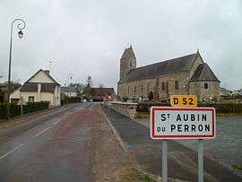
Entrance to the village and the church of Saint-Aubin | |
 Saint-Aubin-du-Perron | |
|
Location within Normandy region  Saint-Aubin-du-Perron | |
| Coordinates: 49°09′09″N 1°22′26″W / 49.1525°N 1.3739°WCoordinates: 49°09′09″N 1°22′26″W / 49.1525°N 1.3739°W | |
| Country | France |
| Region | Normandy |
| Department | Manche |
| Arrondissement | Coutances |
| Canton | Saint-Sauveur-Lendelin |
| Intercommunality | Saint-Sauveur-Lendelin |
| Government | |
| • Mayor (2008–2014) | Rose-Marie Duval |
| Area1 | 7.62 km2 (2.94 sq mi) |
| Population (1999)2 | 219 |
| • Density | 29/km2 (74/sq mi) |
| Time zone | CET (UTC+1) |
| • Summer (DST) | CEST (UTC+2) |
| INSEE/Postal code | 50449 / 50490 |
| Elevation |
15–88 m (49–289 ft) (avg. 84 m or 276 ft) |
|
1 French Land Register data, which excludes lakes, ponds, glaciers > 1 km² (0.386 sq mi or 247 acres) and river estuaries. 2 Population without double counting: residents of multiple communes (e.g., students and military personnel) only counted once. | |
Saint-Aubin-du-Perron is a commune in the Manche department in Normandy in north-western France. Its populated by 229 inhabitants. Yields in 1823 a part of its territory for the creation of common Mesnilbus .
See also
References
http://www.chateau-perron.com/chateau.html
| Wikimedia Commons has media related to Saint-Aubin-du-Perron. |
Template:Manche-geo-article
This article is issued from Wikipedia - version of the 2/11/2016. The text is available under the Creative Commons Attribution/Share Alike but additional terms may apply for the media files.