Vierville, Manche
| Vierville | |
|---|---|
|
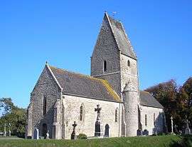
The church of Saint-Éloi | |
 Vierville | |
|
Location within Normandy region  Vierville | |
| Coordinates: 49°21′40″N 1°14′43″W / 49.3611°N 1.2453°WCoordinates: 49°21′40″N 1°14′43″W / 49.3611°N 1.2453°W | |
| Country | France |
| Region | Normandy |
| Department | Manche |
| Arrondissement | Cherbourg-Octeville |
| Canton | Sainte-Mère-Église |
| Intercommunality | Communauté de communes de Sainte-Mère-Église |
| Government | |
| • Mayor (2008–2014) | Bernard Leneveu |
| Area1 | 4.10 km2 (1.58 sq mi) |
| Population (2006)2 | 52 |
| • Density | 13/km2 (33/sq mi) |
| Time zone | CET (UTC+1) |
| • Summer (DST) | CEST (UTC+2) |
| INSEE/Postal code | 50636 / 50480 |
| Elevation |
2–23 m (6.6–75.5 ft) (avg. 36 m or 118 ft) |
|
1 French Land Register data, which excludes lakes, ponds, glaciers > 1 km² (0.386 sq mi or 247 acres) and river estuaries. 2 Population without double counting: residents of multiple communes (e.g., students and military personnel) only counted once. | |
Vierville is a commune in the Manche department in Normandy in north-western France.
Places and monuments
- Mounds Neolithic of Butte (historical monument). Cemetery dating to the Merovingian.
- Church Saint-Eloi (XV), with font emblazoned (XVI).
- Castle (XVIII), listed in the inventory of historical monuments (IMH).
- Fontaine Saint-Eloi and laundry.
- Manoir de Tourville (XVII).[1]
See also
References
| Wikimedia Commons has media related to Vierville (Manche). |
This article is issued from Wikipedia - version of the 7/2/2016. The text is available under the Creative Commons Attribution/Share Alike but additional terms may apply for the media files.