Bréhal
| Bréhal | ||
|---|---|---|
|
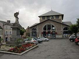
The old town hall | ||
| ||
 Bréhal | ||
|
Location within Normandy region  Bréhal | ||
| Coordinates: 48°53′57″N 1°30′38″W / 48.8992°N 1.5106°WCoordinates: 48°53′57″N 1°30′38″W / 48.8992°N 1.5106°W | ||
| Country | France | |
| Region | Normandy | |
| Department | Manche | |
| Arrondissement | Coutances | |
| Canton | Bréhal | |
| Intercommunality | Plage et Bocage | |
| Government | ||
| • Mayor (2008–2014) | Jules Périer | |
| Area1 | 12.71 km2 (4.91 sq mi) | |
| Population (2009)2 | 3,017 | |
| • Density | 240/km2 (610/sq mi) | |
| Time zone | CET (UTC+1) | |
| • Summer (DST) | CEST (UTC+2) | |
| INSEE/Postal code | 50076 / 50290 | |
| Elevation |
4–71 m (13–233 ft) (avg. 69 m or 226 ft) | |
|
1 French Land Register data, which excludes lakes, ponds, glaciers > 1 km² (0.386 sq mi or 247 acres) and river estuaries. 2 Population without double counting: residents of multiple communes (e.g., students and military personnel) only counted once. | ||
Bréhal is a commune in the Manche department in Normandy in northwestern France.
Population
| Historical population | ||
|---|---|---|
| Year | Pop. | ±% |
| 1793 | 1,159 | — |
| 1800 | 1,373 | +18.5% |
| 1806 | 1,265 | −7.9% |
| 1821 | 1,519 | +20.1% |
| 1831 | 1,732 | +14.0% |
| 1836 | 1,637 | −5.5% |
| 1841 | 1,693 | +3.4% |
| 1846 | 1,577 | −6.9% |
| 1851 | 1,665 | +5.6% |
| 1856 | 1,627 | −2.3% |
| 1861 | 1,538 | −5.5% |
| 1866 | 1,494 | −2.9% |
| 1872 | 1,439 | −3.7% |
| 1876 | 1,517 | +5.4% |
| 1881 | 1,504 | −0.9% |
| 1886 | 1,450 | −3.6% |
| 1891 | 1,400 | −3.4% |
| 1896 | 1,352 | −3.4% |
| 1901 | 1,299 | −3.9% |
| 1906 | 1,294 | −0.4% |
| 1911 | 1,350 | +4.3% |
| 1921 | 1,351 | +0.1% |
| 1926 | 1,252 | −7.3% |
| 1931 | 1,352 | +8.0% |
| 1936 | 1,396 | +3.3% |
| 1946 | 1,420 | +1.7% |
| 1954 | 1,523 | +7.3% |
| 1962 | 1,525 | +0.1% |
| 1968 | 1,568 | +2.8% |
| 1975 | 1,988 | +26.8% |
| 1982 | 2,390 | +20.2% |
| 1990 | 2,351 | −1.6% |
| 1999 | 2,599 | +10.5% |
| 2006 | 2,945 | +13.3% |
| 2009 | 3,017 | +2.4% |
International relations
Bréhal is twinned with Lydney in Gloucestershire.
Heraldry
.svg.png) |
The arms of Bréhal are blazoned : Per fess 1: Gules, a leopard between 8 fleurs de lys (4 above, 4 below); 2 Azure, 3 escallops Or. |
See also
References
| Wikimedia Commons has media related to Bréhal. |
This article is issued from Wikipedia - version of the 9/17/2015. The text is available under the Creative Commons Attribution/Share Alike but additional terms may apply for the media files.