Les Loges-sur-Brécey
| Les Loges-sur-Brécey | |
|---|---|
|
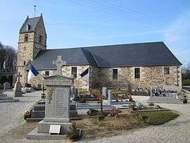
The church of Saint-Pierre | |
 Les Loges-sur-Brécey | |
|
Location within Normandy region  Les Loges-sur-Brécey | |
| Coordinates: 48°46′00″N 1°10′29″W / 48.7667°N 1.1747°WCoordinates: 48°46′00″N 1°10′29″W / 48.7667°N 1.1747°W | |
| Country | France |
| Region | Normandy |
| Department | Manche |
| Arrondissement | Avranches |
| Canton | Brécey |
| Intercommunality | Communauté de communes du Canton de Brécey |
| Government | |
| • Mayor (2008–2014) | Josette Quesnel |
| Area1 | 5.27 km2 (2.03 sq mi) |
| Population (2006)2 | 147 |
| • Density | 28/km2 (72/sq mi) |
| Time zone | CET (UTC+1) |
| • Summer (DST) | CEST (UTC+2) |
| INSEE/Postal code | 50275 / 50370 |
| Elevation |
53–165 m (174–541 ft) (avg. 150 m or 490 ft) |
|
1 French Land Register data, which excludes lakes, ponds, glaciers > 1 km² (0.386 sq mi or 247 acres) and river estuaries. 2 Population without double counting: residents of multiple communes (e.g., students and military personnel) only counted once. | |
Les Loges-sur-Brécey is a commune in the Manche department in Normandy in north-western France.
A small, very rural commune some 5 km North of the small town of Brecey. With no centre to the commune other than the church, the 90 habitations (of which about 10% are holiday homes belonging to both French and British) are spread over a large geographical area. The majority of the population of approximately 150 are farming families, both retired and active. This is augmented by a small number of professional people, artisans and a very small number of English ex-pats. Les Loges sur Brecey is a warm, tightly knit, traditional manchois community.
See also
| Wikimedia Commons has media related to Les Loges-sur-Brécey. |