Sainte-Mère-Église
| Sainte-Mère-Église | ||
|---|---|---|
|
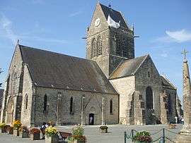
Church with Parachute Memorial | ||
| ||
 Sainte-Mère-Église | ||
|
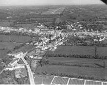
Location within Normandy region  Sainte-Mère-Église | ||
| Coordinates: 49°24′32″N 1°19′05″W / 49.4089°N 1.3181°WCoordinates: 49°24′32″N 1°19′05″W / 49.4089°N 1.3181°W | ||
| Country | France | |
| Region | Normandy | |
| Department | Manche | |
| Arrondissement | Cherbourg | |
| Canton | Carentan | |
| Intercommunality | Baie du Cotentin | |
| Government | ||
| • Mayor (2001–2008) | Jean-Paul Bouet | |
| Area1 | 32.08 km2 (12.39 sq mi) | |
| Population (2013)2 | 2,588 | |
| • Density | 81/km2 (210/sq mi) | |
| Time zone | CET (UTC+1) | |
| • Summer (DST) | CEST (UTC+2) | |
| INSEE/Postal code | 50523 / 50480 | |
| Elevation |
1–41 m (3.3–134.5 ft) (avg. 34 m or 112 ft) | |
|
1 French Land Register data, which excludes lakes, ponds, glaciers > 1 km² (0.386 sq mi or 247 acres) and river estuaries. 2 Population without double counting: residents of multiple communes (e.g., students and military personnel) only counted once. | ||
Sainte-Mère-Église is a commune in the Manche department in Normandy in northwestern France. On 1 January 2016, the former communes of Beuzeville-au-Plain, Chef-du-Pont, Écoquenéauville and Foucarville were merged into Sainte-Mère-Église.[1]
Geography
Sainte-Mère-Église lies in a flat area of the Cotentin peninsula known locally as le Plain (as opposed to the standard French term la plaine).[2] The Plain is bounded on the west by the Merderet River and by the English channel to the east, and by the communes of Valognes and Carentan to the north and south, respectively. Besides Sainte-Mère-Église, the Plain's other major town is Montebourg, and its coast includes Utah Beach.
Although most of the Cotentin Peninsula belongs to the Armorican Massif, the Plain is part of the Paris Basin.[3] Argillaceous limestone from the Sinemurian[4] contributes to the region's dairy product appellation (AOC) Isigny-Sainte-Mère, which it shares with Bessin. Horse breeding has long been practiced in the Plain, which is regarded as the cradle of the Anglo-Norman horse breed, the product of English stallions and mares from the Cotentin Peninsula.[5]
History
Founded in the eleventh century, the earliest records (1080–1082) include the name Sancte Marie Ecclesia, Latin for "Church of St. Mary", while a later document written in Norman-French (1317) mentions Saincte Mariglise. The current French form of the name is ambiguous, with the additional meaning, "Holy Mother Church". The town was significantly involved in the Hundred Years' War as well as the Wars of Religion.
The town's main claim to fame is that it played a significant part in the World War II Normandy landings because this village stood right in the middle of route N13, which the Germans would have most likely used on any significant counterattack on the troops landing on Utah and Omaha Beaches. In the early morning of 6 June 1944 mixed units of the U.S. 82nd Airborne and U.S. 101st Airborne Divisions occupied the town in Mission Boston, giving it the claim to be one of the first towns liberated in the invasion.
D-Day battle
The early landings, at about 0140 directly on the town, resulted in heavy casualties for the paratroopers. Some buildings in town were on fire that night, and they illuminated the sky, making easy targets of the descending men. Some were sucked into the fire. Many hanging from trees and utility poles were shot before they could cut loose.
A well-known incident involved paratrooper John Steele of the 505th Parachute Infantry Regiment (PIR), whose parachute caught on the spire of the town church, and could only observe the fighting going on below. He hung there limply for two hours, pretending to be dead, before the Germans took him prisoner. Steele later escaped from the Germans and rejoined his division when US troops of the 3rd Battalion, 505 Parachute Infantry Regiment attacked the village, capturing thirty Germans and killing another eleven. The incident was portrayed in the movie The Longest Day by actor Red Buttons.
Later that morning, about 0500, a force led by Lt. Colonel Edward C. Krause of the 505th PIR took the town with little resistance. Apparently the German garrison was confused and had retired for the rest of the night. However, heavy German counterattacks began later in the day and into the next. The lightly armed troops held the town until reinforced by tanks from nearby Utah Beach in the afternoon of 7 June.
Krause and Lt. Colonel Benjamin H. Vandervoort both received the Distinguished Service Cross for their actions in the capture of the town. Sgt. George Bowler Tullidge III received the Bronze Star, while a collection of Bible verses and of his letters home, A Paratrooper's Faith was distributed throughout the 82nd Airborne by his parents from after his death until the 1990s. 2nd Lt. Thomas J. Tighe of the 70th Tank Battalion received the Silver Star posthumously for his actions on the morning of June 7th in securing the town, during which he was killed when his tank was hit by German artillery fire.[6]
Henry Langrehr was also involved in the capture of Sainte-Mère-Église. He crashed through a greenhouse roof, as retold in the The Longest Day. On 6 November 2007, along with five other men he received the Legion of Honor medal from the President of France, Nicolas Sarkozy.
Heraldry
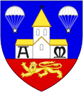 |
The arms of Sainte-Mère-Église are blazoned:
Azure, a church Argent roofed Or charged with the capital letters A and M Sable, issuant from a base Gules charged with a léopard d'or; in chief 2 mullets Argent hanging from parachutes Argent. (On a blue background; a white/silver church, roofed with yellow/gold, marked with the capital letters A and M in black. The red base contains a yellow/gold lion walking to the left. At the top; two white/silver stars hang from white/silver parachutes.) |
Sights
Tourism in Sainte-Mère-Église today centers on its role in the D-Day invasion. There are many small museums (such as the Airborne Museum) and World War II-related giftshops and eating places. A dummy paratrooper hangs from the church spire, commemorating the story of John Steele.
Behind the church is a spring, believed by pilgrims to have healing powers, dedicated to Saint Mewan (Saint Méen).
Gallery
 Parachute Memorial in Sainte-Mère-Église
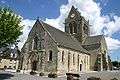 Sainte-Mère-Église Church.
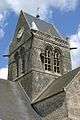 Church bell tower with dummy parachutist.
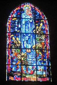 Stained glass window in village chapel depicting the landing of the paratroopers.
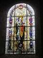 Stained glass window in village chapel depicting Saint Michael and the insignia of various Allied military units that fought in or near the village.
See also
Also of note is that Sainte-Mère-Église is twinned with the English village Sturminster Marshall
References
- ↑ Arrêté préfectoral 2 December 2015 (French)
- ↑ Plain Wikimanche.
- ↑ Guide géologique Normandie Maine. Editions DUNOD. 2ème édition. Page75. ISBN 2-10-050695-1.
- ↑ Guide géologique Normandie Maine. Editions DUNOD. 2ème édition. Page75. ISBN 2-10-050695-1.
- ↑ Rémy Villand, « Au pays des herbages et des marais », La Manche au passé et au présent, éd. Manche-Tourisme, 1984, p. 49.
- ↑ From Armor in Operation Neptune (Establishment of the Normandy Beachhead), compiled by Committee 10, US Army Armored School, Ft. Knox, KY, 1949, pgs 32-35 (accessed Apr/9/12 http://forum.axishistory.com/viewtopic.php?t=51896)
Further reading
- Harrison, Gordan A. (2002) [1951]. "Chapter VIII, The Sixth of June". Cross Channel Attack. The United States in World War II. United States Army Center of Military History. CMH Pub 7-4.
External links
| Wikimedia Commons has media related to Sainte-Mère-Église. |
| Wikivoyage has a travel guide for Sainte-Mère-Église. |
- The Airborne Museum
- The Tourist Office of the District Communities of Sainte-Mère-Église
- A Paratrooper's Faith