Fermanville
| Fermanville | |
|---|---|
|
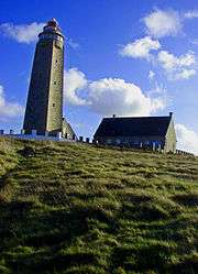
The Cape Lévi lighthouse | |
 Fermanville | |
|
Location within Normandy region  Fermanville | |
| Coordinates: 49°41′08″N 1°27′13″W / 49.6856°N 1.4536°WCoordinates: 49°41′08″N 1°27′13″W / 49.6856°N 1.4536°W | |
| Country | France |
| Region | Normandy |
| Department | Manche |
| Arrondissement | Cherbourg |
| Canton | Val-de-Saire |
| Intercommunality | Communauté de communes de Saint-Pierre-Église |
| Government | |
| • Mayor (2008–2014) | Nicole Belliot-Delacour |
| Area1 | 11.60 km2 (4.48 sq mi) |
| Population (2006)2 | 1,420 |
| • Density | 120/km2 (320/sq mi) |
| Time zone | CET (UTC+1) |
| • Summer (DST) | CEST (UTC+2) |
| INSEE/Postal code | 50178 / 50840 |
| Elevation |
0–136 m (0–446 ft) (avg. 50 m or 160 ft) |
|
1 French Land Register data, which excludes lakes, ponds, glaciers > 1 km² (0.386 sq mi or 247 acres) and river estuaries. 2 Population without double counting: residents of multiple communes (e.g., students and military personnel) only counted once. | |
Fermanville is a commune in the Manche department in north-western France.
French submarine Prométhée sank off Fermanville on 7 July 1932.
Places of Interest
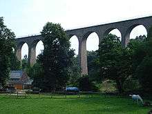
Fermanville Viaduct
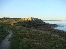
Fort Lévi.
- Fort Lévi : fort built in 1801 on Napoleon's orders ;
- Railway viaduct located in the vallée des moulins village, used until 1951 for the Cherbourg-Barfleur train ;
See also
External links
| Wikimedia Commons has media related to Fermanville. |
- Fermanville official website (in French)
This article is issued from Wikipedia - version of the 3/31/2016. The text is available under the Creative Commons Attribution/Share Alike but additional terms may apply for the media files.