Denneville
| Denneville | ||
|---|---|---|
|
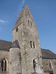
The Denneville church | ||
| ||
 Denneville | ||
|
Location within Normandy region  Denneville | ||
| Coordinates: 49°18′50″N 1°39′32″W / 49.3139°N 1.6589°WCoordinates: 49°18′50″N 1°39′32″W / 49.3139°N 1.6589°W | ||
| Country | France | |
| Region | Normandy | |
| Department | Manche | |
| Arrondissement | Coutances | |
| Canton | La Haye-du-Puits | |
| Intercommunality | Communauté de communes de la Côte des Isles | |
| Area1 | 8.24 km2 (3.18 sq mi) | |
| Population (2006)2 | 524 | |
| • Density | 64/km2 (160/sq mi) | |
| Time zone | CET (UTC+1) | |
| • Summer (DST) | CEST (UTC+2) | |
| INSEE/Postal code | 50160 / 50580 | |
| Elevation |
4–38 m (13–125 ft) (avg. 5 m or 16 ft) | |
| Website | www.denneville.fr | |
|
1 French Land Register data, which excludes lakes, ponds, glaciers > 1 km² (0.386 sq mi or 247 acres) and river estuaries. 2 Population without double counting: residents of multiple communes (e.g., students and military personnel) only counted once. | ||
Denneville is a commune in the Manche department in north-western France.
Heraldry
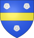 |
The arms of Denneville are blazoned : Azure, a fess or between 3 roses argent.
|
See also
| Wikimedia Commons has media related to Denneville. |
This article is issued from Wikipedia - version of the 2/11/2016. The text is available under the Creative Commons Attribution/Share Alike but additional terms may apply for the media files.