Cerisy-la-Salle
| Cerisy-la-Salle | |
|---|---|
|
Cerisy-la-Salle | |
 Cerisy-la-Salle | |
|
Location within Normandy region  Cerisy-la-Salle | |
| Coordinates: 49°01′37″N 1°16′52″W / 49.0269°N 1.2811°WCoordinates: 49°01′37″N 1°16′52″W / 49.0269°N 1.2811°W | |
| Country | France |
| Region | Normandy |
| Department | Manche |
| Arrondissement | Coutances |
| Canton | Cerisy-la-Salle (Chef-lieu) |
| Intercommunality | Communauté de communes du canton de Cerisy-la-Salle |
| Government | |
| • Mayor (2008–2014) | Yves Simon |
| Area1 | 16.86 km2 (6.51 sq mi) |
| Population (2006)2 | 1,033 |
| • Density | 61/km2 (160/sq mi) |
| Time zone | CET (UTC+1) |
| • Summer (DST) | CEST (UTC+2) |
| INSEE/Postal code | 50111 / 50210 |
| Elevation |
58–169 m (190–554 ft) (avg. 135 m or 443 ft) |
|
1 French Land Register data, which excludes lakes, ponds, glaciers > 1 km² (0.386 sq mi or 247 acres) and river estuaries. 2 Population without double counting: residents of multiple communes (e.g., students and military personnel) only counted once. | |
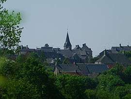
Cerisy-la-Salle is a commune in the Manche department in Normandy in north-western France.
Heraldry
.svg.png) |
The arms of Cerisy-la-Salle are blazoned : Vert, a bend cotissed argent, and in chief a lion passant Or. |
See also
| Wikimedia Commons has media related to Cerisy-la-Salle. |
This article is issued from Wikipedia - version of the 7/5/2016. The text is available under the Creative Commons Attribution/Share Alike but additional terms may apply for the media files.