Ouville
| Ouville | |
|---|---|
|
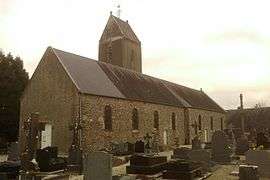
The church of Notre-Dame | |
 Ouville | |
|
Location within Normandy region  Ouville | |
| Coordinates: 49°01′12″N 1°21′40″W / 49.02°N 1.3611°WCoordinates: 49°01′12″N 1°21′40″W / 49.02°N 1.3611°W | |
| Country | France |
| Region | Normandy |
| Department | Manche |
| Arrondissement | Coutances |
| Canton | Cerisy-la-Salle |
| Intercommunality | Communauté de communes du Canton de Cerisy-la-Salle |
| Government | |
| • Mayor (2008–2014) | Daniel Lefranc |
| Area1 | 11.20 km2 (4.32 sq mi) |
| Population (2006)2 | 430 |
| • Density | 38/km2 (99/sq mi) |
| Time zone | CET (UTC+1) |
| • Summer (DST) | CEST (UTC+2) |
| INSEE/Postal code | 50389 / 50210 |
| Elevation |
29–121 m (95–397 ft) (avg. 103 m or 338 ft) |
|
1 French Land Register data, which excludes lakes, ponds, glaciers > 1 km² (0.386 sq mi or 247 acres) and river estuaries. 2 Population without double counting: residents of multiple communes (e.g., students and military personnel) only counted once. | |
Ouville is a commune in the Manche department in Normandy in north-western France.
History
Ouf's farm. Ouf from the Norse Ulfr (wolf), which survives in the Norman surname Ouf, common in the region of le Havre.
Heraldry
.svg.png) |
The arms of Ouville are blazoned : Argent, a latin cross between to fleurs de lys azure. |
References
See also
| Wikimedia Commons has media related to Ouville. |
This article is issued from Wikipedia - version of the 2/27/2015. The text is available under the Creative Commons Attribution/Share Alike but additional terms may apply for the media files.