Saint-Nicolas-de-Pierrepont
| Saint-Nicolas-de-Pierrepont | |
|---|---|
|
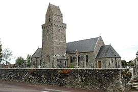
The church of Saint-Nicolas-de-Pierrepont | |
 Saint-Nicolas-de-Pierrepont | |
|
Location within Normandy region  Saint-Nicolas-de-Pierrepont | |
| Coordinates: 49°19′27″N 1°35′09″W / 49.3242°N 1.5858°WCoordinates: 49°19′27″N 1°35′09″W / 49.3242°N 1.5858°W | |
| Country | France |
| Region | Normandy |
| Department | Manche |
| Arrondissement | Coutances |
| Canton | La Haye-du-Puits |
| Intercommunality | Haye-du-Puits |
| Government | |
| • Mayor (2008–2014) | Raymond Létang |
| Area1 | 8.13 km2 (3.14 sq mi) |
| Population (1999)2 | 249 |
| • Density | 31/km2 (79/sq mi) |
| Time zone | CET (UTC+1) |
| • Summer (DST) | CEST (UTC+2) |
| INSEE/Postal code | 50528 / 50250 |
| Elevation |
7–123 m (23–404 ft) (avg. 32 m or 105 ft) |
|
1 French Land Register data, which excludes lakes, ponds, glaciers > 1 km² (0.386 sq mi or 247 acres) and river estuaries. 2 Population without double counting: residents of multiple communes (e.g., students and military personnel) only counted once. | |
Saint-Nicolas-de-Pierrepont is a commune in the Manche department in Normandy in north-western France.
See also
References
| Wikimedia Commons has media related to Saint-Nicolas-de-Pierrepont. |
This article is issued from Wikipedia - version of the 2/12/2016. The text is available under the Creative Commons Attribution/Share Alike but additional terms may apply for the media files.