Valcanville
| Valcanville | ||
|---|---|---|
|
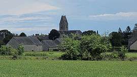
Panorama | ||
| ||
 Valcanville | ||
|
Location within Normandy region  Valcanville | ||
| Coordinates: 49°38′40″N 1°19′41″W / 49.6444°N 1.3281°WCoordinates: 49°38′40″N 1°19′41″W / 49.6444°N 1.3281°W | ||
| Country | France | |
| Region | Normandy | |
| Department | Manche | |
| Arrondissement | Cherbourg-Octeville | |
| Canton | Quettehou | |
| Intercommunality | Communauté de communes du Val de Saire | |
| Government | ||
| • Mayor (2008–2014) | Jacques Lecoq | |
| Area1 | 6.45 km2 (2.49 sq mi) | |
| Population (2006)2 | 362 | |
| • Density | 56/km2 (150/sq mi) | |
| Time zone | CET (UTC+1) | |
| • Summer (DST) | CEST (UTC+2) | |
| INSEE/Postal code | 50613 / 50760 | |
| Elevation |
8–86 m (26–282 ft) (avg. 25 m or 82 ft) | |
|
1 French Land Register data, which excludes lakes, ponds, glaciers > 1 km² (0.386 sq mi or 247 acres) and river estuaries. 2 Population without double counting: residents of multiple communes (e.g., students and military personnel) only counted once. | ||
.svg.png)
Valcanville is a commune in the Manche department in Normandy in north-western France.
See also
| Wikimedia Commons has media related to Valcanville. |
This article is issued from Wikipedia - version of the 2/11/2016. The text is available under the Creative Commons Attribution/Share Alike but additional terms may apply for the media files.