Hadsund Syd
.JPG)
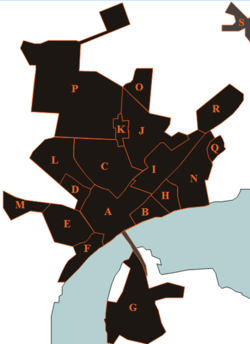
A: Hadsund Center
B: Munchs eng
C: Rosendal
D: Himmerlandsgade (district)
E: Pip-district
F: Forest-kvarteret
G: Hadsund South
H: Ved Stranden
I: Island-district
J: Holterne
K: Søndergårde
L: Hadsund Huse
M: Højmarken
N: Rolighed
O: Bøgelunden
P: Industrial North
Q: Molhøj
R: Industrial East
Hadsund South (Danish:Hadsund Syd) (originally Sønder Hadsund) lies immediately south of Hadsund bridge (about 250 meters). The district has a population of 477 (1.January 2014)[1] and was founded approximately. 1880th In Hadsund South is Hadsund South Station, Ferry Inn Hotel South.
History
Hadsund South was first mentioned in 1486 and was spelled Sundkrogen after the inn who prepared the ferry site (today Færgekroen). Originally consisted all the buildings by a ferry inn and a jetty. Later, brought a railway connection with the terminus at the inn. Basis for an actual urban growth were however only created when there was built a solid rail across the sound. Soon, came the first factory south of the strait and associated to the developed residential area.
External links
 Media related to Hadsund at Wikimedia Commons
- Mariagerfjord municipality's official website) (Danish)
- Hadsund Trade association
- a page about Hadsund
References
- ↑ BEF44: Population 1.January by urban areas database from Statistics Denmark
- Municipal statistics: NetBorger Kommunefakta, delivered from KMD aka Kommunedata (Municipal Data)
- Municipal mergers and neighbors: Eniro new municipalities map
Coordinates: 56°43′N 10°07′E / 56.717°N 10.117°E