New Town, Missouri
- This article is about the community in St. Charles County, for the town located in St. Charles City, see: Newtown, Missouri.
| New Town at St. Charles, Missouri | |
|---|---|
|
Lakeside houses in New Town | |
| Coordinates: 38°50′12″N 90°29′41″W / 38.83656°N 90.49471°WCoordinates: 38°50′12″N 90°29′41″W / 38.83656°N 90.49471°W | |
| Country | United States |
| State | Missouri |
| County | St. Charles |
| Elevation | 439.6 ft (134 m) |
| Time zone | CST (UTC-6) |
| • Summer (DST) | CDT (UTC-5) |
| Area code(s) | 636 |
| Website | http://www.newtownatstcharles.com/ |
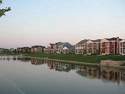
New Town at St. Charles is a partially completed planned community within the city of St. Charles, Missouri. The community's developers espouse the principles of Traditional Neighborhood Design and New Urbanism. New Urbanists designers advocate walkable, mixed-use neighborhoods with relatively high population densities, as an alternative to the urban sprawl of conventional, automobile-centered suburbs.[1] When complete, New Town will cover 755 acres (3.06 km2), will contain up to 5,700 dwellings, and will be one of the largest new urbanist communities in the United States. It is expected to take 12 to 15 years to complete.[2]
Natural environment
New Town is located in northeastern St. Charles County, approximately 18 miles (29 km) from the confluence of the Missouri and Mississippi rivers. New Town was built on a small natural ridge and is surrounded by low farmland and wetland. The area is home to many species of ducks,[3] cranes, geese, snakes, deer, fish, hawks, and eagles. The Great Rivers Greenway District and Katy Trail State Park both run close by New Town and provide residents access to wildlife.
In 1993, the Midwest experienced the most severe flood in recent history, and much of St. Charles County was underwater. Because of its higher elevation, little flooding occurred on the future site of New Town. Nevertheless, New Town's developers built a series of lakes and canals for drainage and used the excavated dirt to raise the site's elevation by several feet.
History
Greg Whittaker of Whittaker Builders, Inc.,[4] the architectural firm of Duany Plater-Zyberk & Company, and the City of St. Charles conducted a public charrette to design New Town in February 2003. A community incorporating a wide range of housing types, parks and greens, an organic farm, and a total of six neighborhood centers was planned. Construction began in 2004, and the first residents arrived in April 2005.
Economics
In addition to the residential and recreational development, the planned community includes commercial space and currently has a few small businesses, restaurants, cafés. The community is also the headquarters of Whittaker Builders, Inc.[5] In October 2009, Whittaker Builders filed for Chapter 11 bankruptcy.[6]
Transportation
The New Town settlement is located near Missouri Route 370, an east-west freeway connecting St. Peters, St. Charles and northern St. Louis County. New Town is also a planned stop for the St. Charles Streetcar project, a future heritage streetcar line. A planned 8-mile (13 km) route connecting New Town, the historic downtown of St. Charles city, the St. Charles Convention Center, and the Family Arena sports and performance arena.[7]
References
- ↑ http://www.newurbannews.com/NewTownInsideJul05.html
- ↑ http://www.southernliving.com/travel/south-west/new-town-st-charles-st-louis-missouri-00400000046775/
- ↑ Rushton, Bruce (2002-11-27). "Odd Ducks". Riverfront Times. Retrieved 2010-01-09.
- ↑ Trask, Mike (2009). "Whittaker Builders continues to sell New Town in St. Charles City". Missouri Lawyers Media.
- ↑ Trask, Mike (2009). "Whittaker Builders continues to sell New Town in St. Charles City". Missouri Lawyers Media.
- ↑ http://blogs.riverfronttimes.com/dailyrft/2009/10/new_town_developer_files_bankruptcy_whittaker_homes_plans_to_reorganize.php. Missing or empty
|title=(help) - ↑ http://www.newtownatstcharles.com/Streetcars.aspx
External links
| Topics |  | |
|---|---|---|
| Central city | ||
| Largest cities (over 50,000 in 2010) | ||
| Medium-sized cities (over 20,000 in 2010) | ||
| Largest towns and villages (over 10,000 in 2010) |
| |
| Missouri Counties | ||
| Illinois Counties | ||
| Subregions | ||
Municipalities and communities of St. Charles County, Missouri, United States | ||
|---|---|---|
| Cities | 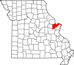 | |
| Villages | ||
| Townships |
| |
| CDP | ||
| Other unincorporated communities |
| |
| Ghost towns |
| |
| Footnotes | ‡This populated place also has portions in an adjacent county or counties | |