Dignac
| Dignac | ||
|---|---|---|
 | ||
| ||
 Dignac | ||
|
Location within Nouvelle-Aquitaine region  Dignac | ||
| Coordinates: 45°33′26″N 0°16′52″E / 45.5572°N 0.2811°ECoordinates: 45°33′26″N 0°16′52″E / 45.5572°N 0.2811°E | ||
| Country | France | |
| Region | Nouvelle-Aquitaine | |
| Department | Charente | |
| Arrondissement | Angoulême | |
| Canton | Villebois-Lavalette | |
| Intercommunality | Vallée de l'Échelle | |
| Government | ||
| • Mayor (2008–2014) | Françoise Delage | |
| Area1 | 27.66 km2 (10.68 sq mi) | |
| Population (2008)2 | 1,298 | |
| • Density | 47/km2 (120/sq mi) | |
| Time zone | CET (UTC+1) | |
| • Summer (DST) | CEST (UTC+2) | |
| INSEE/Postal code | 16119 / 16410 | |
| Elevation | 105–224 m (344–735 ft) | |
|
1 French Land Register data, which excludes lakes, ponds, glaciers > 1 km² (0.386 sq mi or 247 acres) and river estuaries. 2 Population without double counting: residents of multiple communes (e.g., students and military personnel) only counted once. | ||

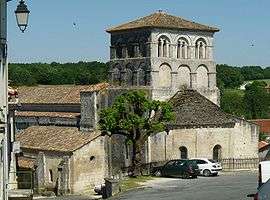
Dignac is a commune in the Charente department in southwestern France.
Population
| Historical population | ||
|---|---|---|
| Year | Pop. | ±% |
| 1793 | 906 | — |
| 1800 | 519 | −42.7% |
| 1806 | 1,056 | +103.5% |
| 1821 | 1,141 | +8.0% |
| 1831 | 1,145 | +0.4% |
| 1841 | 1,537 | +34.2% |
| 1846 | 1,518 | −1.2% |
| 1851 | 1,659 | +9.3% |
| 1856 | 1,513 | −8.8% |
| 1861 | 1,436 | −5.1% |
| 1866 | 1,401 | −2.4% |
| 1872 | 1,288 | −8.1% |
| 1876 | 1,321 | +2.6% |
| 1881 | 1,244 | −5.8% |
| 1886 | 1,244 | +0.0% |
| 1891 | 1,252 | +0.6% |
| 1896 | 1,126 | −10.1% |
| 1901 | 1,115 | −1.0% |
| 1906 | 1,107 | −0.7% |
| 1911 | 1,052 | −5.0% |
| 1921 | 975 | −7.3% |
| 1926 | 905 | −7.2% |
| 1931 | 850 | −6.1% |
| 1936 | 857 | +0.8% |
| 1946 | 885 | +3.3% |
| 1954 | 851 | −3.8% |
| 1962 | 793 | −6.8% |
| 1968 | 843 | +6.3% |
| 1975 | 896 | +6.3% |
| 1982 | 1,147 | +28.0% |
| 1990 | 1,230 | +7.2% |
| 1999 | 1,281 | +4.1% |
| 2008 | 1,298 | +1.3% |
See also
References
| Wikimedia Commons has media related to Dignac. |
This article is issued from Wikipedia - version of the 2/11/2016. The text is available under the Creative Commons Attribution/Share Alike but additional terms may apply for the media files.