Étagnac
| Étagnac | |
|---|---|
|
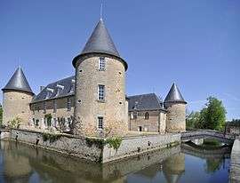
Chateau of Rochebrune | |
 Étagnac | |
|
Location within Nouvelle-Aquitaine region  Étagnac | |
| Coordinates: 45°53′44″N 0°46′47″E / 45.8956°N 0.7797°ECoordinates: 45°53′44″N 0°46′47″E / 45.8956°N 0.7797°E | |
| Country | France |
| Region | Nouvelle-Aquitaine |
| Department | Charente |
| Arrondissement | Confolens |
| Canton | Chabanais |
| Intercommunality | Haute-Charente |
| Government | |
| • Mayor (2008–2014) | Henri de Richemont |
| Area1 | 29.23 km2 (11.29 sq mi) |
| Population (2008)2 | 989 |
| • Density | 34/km2 (88/sq mi) |
| Time zone | CET (UTC+1) |
| • Summer (DST) | CEST (UTC+2) |
| INSEE/Postal code | 16132 / 16150 |
| Elevation |
150–284 m (492–932 ft) (avg. 228 m or 748 ft) |
|
1 French Land Register data, which excludes lakes, ponds, glaciers > 1 km² (0.386 sq mi or 247 acres) and river estuaries. 2 Population without double counting: residents of multiple communes (e.g., students and military personnel) only counted once. | |
Étagnac is a commune in the Charente department in southwestern France.
Population
| Historical population | ||
|---|---|---|
| Year | Pop. | ±% |
| 1793 | 1,291 | — |
| 1800 | 1,260 | −2.4% |
| 1806 | 1,305 | +3.6% |
| 1821 | 1,412 | +8.2% |
| 1831 | 1,471 | +4.2% |
| 1841 | 1,444 | −1.8% |
| 1846 | 1,520 | +5.3% |
| 1851 | 1,605 | +5.6% |
| 1856 | 1,522 | −5.2% |
| 1861 | 1,473 | −3.2% |
| 1866 | 1,560 | +5.9% |
| 1872 | 1,512 | −3.1% |
| 1876 | 1,434 | −5.2% |
| 1881 | 1,530 | +6.7% |
| 1886 | 1,526 | −0.3% |
| 1891 | 1,535 | +0.6% |
| 1896 | 1,551 | +1.0% |
| 1901 | 1,506 | −2.9% |
| 1906 | 1,468 | −2.5% |
| 1911 | 1,400 | −4.6% |
| 1921 | 1,232 | −12.0% |
| 1926 | 1,168 | −5.2% |
| 1931 | 1,165 | −0.3% |
| 1936 | 1,039 | −10.8% |
| 1946 | 1,007 | −3.1% |
| 1954 | 1,041 | +3.4% |
| 1962 | 987 | −5.2% |
| 1968 | 950 | −3.7% |
| 1975 | 910 | −4.2% |
| 1982 | 966 | +6.2% |
| 1990 | 949 | −1.8% |
| 1999 | 982 | +3.5% |
| 2008 | 989 | +0.7% |
See also
References
| Wikimedia Commons has media related to Étagnac. |
This article is issued from Wikipedia - version of the 2/22/2013. The text is available under the Creative Commons Attribution/Share Alike but additional terms may apply for the media files.