Xambes
| Xambes | |
|---|---|
|
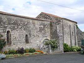
Notre-Dame church | |
 Xambes | |
|
Location within Nouvelle-Aquitaine region  Xambes | |
| Coordinates: 45°49′38″N 0°06′20″E / 45.8272°N 0.1056°ECoordinates: 45°49′38″N 0°06′20″E / 45.8272°N 0.1056°E | |
| Country | France |
| Region | Nouvelle-Aquitaine |
| Department | Charente |
| Arrondissement | Angoulême |
| Canton | Saint-Amant-de-Boixe |
| Intercommunality | Boixe |
| Government | |
| • Mayor (2008–2014) | Jean-Louis Stasiak |
| Area1 | 5.25 km2 (2.03 sq mi) |
| Population (2008)2 | 302 |
| • Density | 58/km2 (150/sq mi) |
| Time zone | CET (UTC+1) |
| • Summer (DST) | CEST (UTC+2) |
| INSEE/Postal code | 16423 / 16330 |
| Elevation |
65–133 m (213–436 ft) (avg. 80 m or 260 ft) |
|
1 French Land Register data, which excludes lakes, ponds, glaciers > 1 km² (0.386 sq mi or 247 acres) and river estuaries. 2 Population without double counting: residents of multiple communes (e.g., students and military personnel) only counted once. | |
Xambes is a commune in the Charente department in southwestern France.
Population
| Historical population | ||
|---|---|---|
| Year | Pop. | ±% |
| 1793 | 547 | — |
| 1800 | 576 | +5.3% |
| 1806 | 568 | −1.4% |
| 1821 | 606 | +6.7% |
| 1831 | 621 | +2.5% |
| 1841 | 622 | +0.2% |
| 1846 | 666 | +7.1% |
| 1851 | 626 | −6.0% |
| 1856 | 579 | −7.5% |
| 1861 | 590 | +1.9% |
| 1866 | 587 | −0.5% |
| 1872 | 608 | +3.6% |
| 1876 | 544 | −10.5% |
| 1881 | 489 | −10.1% |
| 1886 | 406 | −17.0% |
| 1891 | 356 | −12.3% |
| 1896 | 342 | −3.9% |
| 1901 | 324 | −5.3% |
| 1906 | 343 | +5.9% |
| 1911 | 376 | +9.6% |
| 1921 | 326 | −13.3% |
| 1926 | 320 | −1.8% |
| 1931 | 306 | −4.4% |
| 1936 | 316 | +3.3% |
| 1946 | 328 | +3.8% |
| 1954 | 298 | −9.1% |
| 1962 | 289 | −3.0% |
| 1968 | 300 | +3.8% |
| 1975 | 284 | −5.3% |
| 1982 | 297 | +4.6% |
| 1990 | 320 | +7.7% |
| 1999 | 320 | +0.0% |
| 2008 | 302 | −5.6% |
See also
References
| Wikimedia Commons has media related to Xambes. |
This article is issued from Wikipedia - version of the 9/10/2016. The text is available under the Creative Commons Attribution/Share Alike but additional terms may apply for the media files.