Balzac, Charente
| Balzac | ||
|---|---|---|
|
Old well in front of the Chateau | ||
| ||
 Balzac | ||
|
Location within Nouvelle-Aquitaine region  Balzac | ||
| Coordinates: 45°42′38″N 0°08′14″E / 45.7106°N 0.1372°ECoordinates: 45°42′38″N 0°08′14″E / 45.7106°N 0.1372°E | ||
| Country | France | |
| Region | Nouvelle-Aquitaine | |
| Department | Charente | |
| Arrondissement | Angoulême | |
| Canton | Gond-Pontouvre | |
| Intercommunality | Braconne et Charente | |
| Government | ||
| • Mayor (1995–2020) | Jean-Claude Courari | |
| Area1 | 9.64 km2 (3.72 sq mi) | |
| Population (2010)2 | 1,303 | |
| • Density | 140/km2 (350/sq mi) | |
| Time zone | CET (UTC+1) | |
| • Summer (DST) | CEST (UTC+2) | |
| INSEE/Postal code | 16026 / 16430 | |
| Elevation |
30–102 m (98–335 ft) (avg. 40 m or 130 ft) | |
|
1 French Land Register data, which excludes lakes, ponds, glaciers > 1 km² (0.386 sq mi or 247 acres) and river estuaries. 2 Population without double counting: residents of multiple communes (e.g., students and military personnel) only counted once. | ||

Balzac is a French commune in the Charente department in the Nouvelle-Aquitaine region of south-western France.
The inhabitants of the commune are known as Balzatois or Balzatoises.[1]
Geography
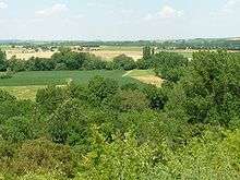
Balzac is located some 7 km north-west of Angoulême. Access to the commune is by the D737 from Angoulême which passes through the east of the commune and the town continuing north to Montignac-Charente. The D105 branches off the D737 north of the town and goes east to Champniers. The D406 also branches off the D737 and goes west to Vindelle. Apart from the town there are the hamlets of Coursac, La Chapelle, Les Chabots, and Les Courlis in the commune. The commune is mostly farmland with a small forest in the south-west and a significant urban area for the town.[2]
Geology and terrain
Balzac occupies the interior of a wide bend of the Charente. The bedrock of the large eastern half of the commune, which is the highest in altitude, consists of limestone dating from the Upper Jurassic (Kimmeridgian) period.
The centre of the town, between Labbés, Genin, and Texier, is located on old alluvium from the Quaternary period.
The western part of the commune, between La Chapelle and Chabots, contains other alluvial deposits which form a low terrace. The river bed (floodplain) is itself made up of more recent alluvium (silt, sandy clay, and peat).[3][4][5][6]
The terrain that separates the valley of the Charente from that of the Argence forms a kind of long cliff, very high and steep in its northern part, which is the concave side of the bend in the river near the villages of Coursac and Font-Saint-Martin, which gradually decreases in height to end at the foot of the Chateau of Balzac.
The highest point in the commune is at an altitude of 102 m east at Puylebin to the east of Coursac. The lowest point is 30 m at on the Charente river at the confluence of the Argence. The village is about 60 m above sea level.[7]
Hydrography
The Charente river forms the entire south, west, and north-west border of the commune as it flows around the commune and continues south-east to eventually join the Atlantic Ocean at Rochefort. The Argence flows from the north-east and forms much of the eastern border where it joins the Charente in the south-eastern corner of the commune.[2]
Climate
The climate is oceanic Aquitaine and similar to the town of Cognac where the departmental weather station is located.
| Town | Sunshine (hours/yr) |
Rain (mm/yr) | Snow (days/yr) | Storm (days/yr) | Fog (days/yr) |
|---|---|---|---|---|---|
| National Average | 1,973 | 770 | 14 | 22 | 40 |
| Balzac[9] | 2,027 | 763 | 3 | 23 | 54 |
| Paris | 1,661 | 637 | 12 | 18 | 10 |
| Nice | 2,724 | 767 | 1 | 29 | 1 |
| Strasbourg | 1,693 | 665 | 29 | 29 | 56 |
| Brest | 1,605 | 1,211 | 7 | 12 | 75 |
| Climate data for Cognac | |||||||||||||
|---|---|---|---|---|---|---|---|---|---|---|---|---|---|
| Month | Jan | Feb | Mar | Apr | May | Jun | Jul | Aug | Sep | Oct | Nov | Dec | Year |
| Average high °C (°F) | 9.4 (48.9) |
11.0 (51.8) |
14.4 (57.9) |
16.9 (62.4) |
20.8 (69.4) |
24.3 (75.7) |
26.8 (80.2) |
26.7 (80.1) |
23.5 (74.3) |
19.0 (66.2) |
13.0 (55.4) |
9.8 (49.6) |
18.0 (64.4) |
| Daily mean °C (°F) | 6.1 (43) |
6.9 (44.4) |
9.7 (49.5) |
11.9 (53.4) |
15.8 (60.4) |
19.0 (66.2) |
21.1 (70) |
20.9 (69.6) |
17.9 (64.2) |
14.4 (57.9) |
9.3 (48.7) |
6.6 (43.9) |
13.3 (55.9) |
| Average low °C (°F) | 2.8 (37) |
2.8 (37) |
4.9 (40.8) |
6.9 (44.4) |
10.6 (51.1) |
13.6 (56.5) |
15.3 (59.5) |
15.0 (59) |
12.3 (54.1) |
9.9 (49.8) |
5.6 (42.1) |
3.3 (37.9) |
8.6 (47.5) |
| Average precipitation mm (inches) | 70.5 (2.776) |
51.4 (2.024) |
57.2 (2.252) |
69.6 (2.74) |
63.8 (2.512) |
50.6 (1.992) |
47.4 (1.866) |
45.3 (1.783) |
59.3 (2.335) |
79.5 (3.13) |
85.1 (3.35) |
83.1 (3.272) |
762.8 (30.031) |
| Average precipitation days (≥ 1 mm) | 11.6 | 9.2 | 10.1 | 11.2 | 10.5 | 7.4 | 6.9 | 6.5 | 8.0 | 11.2 | 11.5 | 11.6 | 115.7 |
| Mean monthly sunshine hours | 77.3 | 111.1 | 160.2 | 179.3 | 211.4 | 351.4 | 254.6 | 239.4 | 219.3 | 141.6 | 91.4 | 89.6 | 2,026.6 |
| Source: Meteorological data for Cognac - 59m altitude, from 1981 to 2010 January 2015 (French) | |||||||||||||

Neighbouring communes and villages[2]
 |
Vindelle | Vars | Anais | |
| Asnières-sur-Nouère | |
Champniers | ||
| ||||
| | ||||
| Gond-Pontouvre |
Toponymy
Old forms of the name Balzac are Balazacum and Balazaco in 1298.[10]
According to Dauzat, the origin of the name Balzac dates back to a Gallo-Roman person Ballitius, which itself is derived from Ballius, to which is added the suffix -acum which would give Ballitiacum or "Domain of Ballitius".[11] According to other sources, Balatius was the name of a Gallic man, derived from Balatos.[12][13]
History
Aerial archaeology has revealed evidence of a Neolithic Bronze Age Promontory fort on the slopes of Coursac in a position dominating the Charente.[14]
A Chateau existed in the 12th century and Balzac was a former fief under the Bishopric of Angoulême and the barony of Tourriers which was acquired in 1398 by Guy de La Rochefoucauld. From the 12th to the 17th century the chateau passed through many hands. The present chateau was rebuilt on the same site in 1600 by Guillaume Guez and his wife who left from time to time for their house in Angoulême. It was the residence of the family Guez de Balzac and Jean-Louis Guez de Balzac, the "Restorer of the French Language", lived there.
From 4 March to 29 August 1619 Marie de' Medici was hosted there by the Guez family, "not wishing to stay elsewhere until the peace that made her son Louis XIII". The castle became the crossroads for personalities of the time during her stay - such as Cardinal Richelieu, the Duke of Épernon, the Cardinal de La Rochefoucauld, and the Count of Bethune.[15]
The road to Vars was a transport route by donkey for Salt to the port of Basseau.[16] The name la Montée des Sauniers (Ascent of Salt workers) above Coursac came from this.[7]
Formerly the Terrier de Bourguignol, then called the Plantier de Bourguignone, located near the Pont Suraud (Suraud Bridge) on the Argence was a dolmen called the Tomb of Bourguignon which was still visible in 1760.[17][18]
At the beginning of the 20th century cherries and peas from Balzac were particularly appreciated from Angoulême to Paris. The fields provided milk feeding two major dairy factories in the commune, run by Messrs. Hortolan and Rochier.[19]
Heraldry
 |
Coat of Arms on official website but image not available in Wikipedia
Blazon: |
Administration

| From | To | Name | Party | Position |
|---|---|---|---|---|
| 1995 | 2020 | Jean-Claude Courari |
(Not all data is known)
Demography
In 2010 the commune had 1,303 inhabitants. The evolution of the number of inhabitants is known from the population censuses conducted in the commune since 1793. From the 21st century, a census of communes with fewer than 10,000 inhabitants is held every five years, unlike larger communes that have a sample survey every year.[Note 1]
| 1793 | 1800 | 1806 | 1821 | 1831 | 1836 | 1841 | 1846 | 1851 |
|---|---|---|---|---|---|---|---|---|
| 957 | 1,016 | 905 | 961 | 1,000 | - | 968 | 942 | 928 |
| 1856 | 1861 | 1866 | 1872 | 1876 | 1881 | 1886 | 1891 | 1896 |
|---|---|---|---|---|---|---|---|---|
| 918 | 838 | 815 | 785 | 780 | 768 | 798 | 727 | 705 |
| 1901 | 1906 | 1911 | 1921 | 1926 | 1931 | 1936 | 1946 | 1954 |
|---|---|---|---|---|---|---|---|---|
| 688 | 708 | 644 | 612 | 605 | 623 | 613 | 621 | 644 |
| 1962 | 1968 | 1975 | 1982 | 1990 | 1999 | 2006 | 2010 | - |
|---|---|---|---|---|---|---|---|---|
| 606 | 687 | 809 | 934 | 1,185 | 1,237 | 1,233 | 1,303 | - |
Sources : Ldh/EHESS/Cassini until 1962, INSEE database from 1968 (population without double counting and municipal population from 2006)

Balzac lost 30% of its population in the second half of the 19th century which then stabilised and experienced consistent growth in the last quarter of the 20th century.
Distribution of Age Groups

Percentage Distribution of Age Groups in Balzac and Charente Department in 2010
| Balzac | Balzac | Charente | Charente | |
|---|---|---|---|---|
| Age Range | Men | Women | Men | Women |
| 0 to 14 Years | 17.2 | 17.1 | 17.3 | 15.4 |
| 15 to 29 Years | 12.1 | 10.1 | 16.4 | 14.3 |
| 30 to 44 Years | 18.9 | 20.0 | 18.7 | 18.1 |
| 45 to 59 Years | 27.1 | 28.1 | 22.1 | 21.5 |
| 60 to 74 Years | 16.4 | 14.3 | 16.2 | 16.6 |
| 75 to 89 Years | 8.1 | 9.7 | 8.8 | 12.5 |
| 90 Years+ | 0.2 | 0.8 | 0.5 | 1.6 |
Sources:
- Evolution and Structure of the population of the Commune in 2010, INSEE.
- Evolution and Structure of the population of the Department in 2010, INSEE.
Facilities
Education
The school is an Inter-communal Educational Grouping (RPI) with Vindelle. Balzac has a primary school (Nursery and from CP to CE2) and Vindelle has an elementary school (from CE2 to CM2). The Jean Caillard High School for Balzac is located in Genins.[22]
Sites and monuments


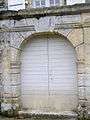
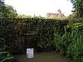
- The Chateau of Balzac (17th century)
 is registered as an historical monument.[23] was built by the father of Jean-Louis Guez de Balzac. This chateau has lodgings which overlook the Charente and is surrounded by a park enclosed by walls with pierced portals. There are also a canal, a fishpond, a lavoir, and a feudal church.
 - The Parish church of Saint Martin is located in the town next to the castle. It is of Romanesque architecture and dates from the 12th century.[24]
Balzac is also the location of the headquarters of the Community of communes of Braconne and Charente.
Chateau of Balzac Picture Gallery
-
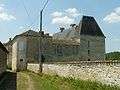
The Chateau
-

Gate at the Chateau entrance
-
Entrance to the Chateau
-

The Lavoir in the Chateau
-
The fishpond
-

The kitchen in the Chateau
-

The well in front of the Chateau
Notable people linked to the commune
- Jean-Louis Guez de Balzac (1597-1654), French writer, lived in the Château of Balzac.
See also
External links
- Balzac official website (French)
- Balzac on Villages of France website, 2000 (French)
- Balzac on Lion1906
- Balzac on Google Maps
- Balzac on Géoportail, National Geographic Institute (IGN) website (French)
- Balzac on the 1750 Cassini Map
- Balzac on the INSEE website (French)
- INSEE (French)
Notes and references
Notes
- ↑ At the beginning of the 21st century, the methods of identification have been modified by Law No. 2002-276 of 27 February 2002, the so-called "law of local democracy" and in particular Title V "census operations" allows, after a transitional period running from 2004 to 2008, the annual publication of the legal population of the different French administrative districts. For communes with a population greater than 10,000 inhabitants, a sample survey is conducted annually, the entire territory of these communes is taken into account at the end of the period of five years. The first "legal population" after 1999 under this new law came into force on 1 January 2009 and was based on the census of 2006.
References
- ↑ Inhabitants of Charente (French)
- 1 2 3 Google Maps
- ↑ Infoterre Visualiser, BRGM website (French)
- ↑ BRGM Map on Géoportail (French)
- ↑ Notice on the Mansle page, BRGM, 1984, Infoterre website, consulted on 13 November 2011 (French)
- ↑ Notice on the Angoulême page, BRGM, 1973, Infoterre website, consulted on 17 November 2011 (French)
- 1 2 IGN Map on Géoportail (French)
- ↑ Paris, Nice, Strasbourg, Brest
- ↑ Data from the Station at Cognac from 1981 to 2010 (French)
- ↑ Book of Fiefs of Guillaume de Blaye, Bishop of Angoulême (the "Liber feodorum"), Jean Nanglard, Vol. 5, Société archéologique et historique de la Charente, 1905 (1st ed. 1273), 404 p., p. 96, 228, 253, 274 (Latin)
- ↑ Albert Dauzat and Charles Rostaing, Etymological Dictionary of place names in France, Paris, Librairie Guénégaud, 1989, 738 p. (ISBN 2-85023-076-6), p. 50 (French)
- ↑ Revue celtique, 1907, p.94 (French)
- ↑ Jean Talbert, Origin of Place Names, 1928 (French)
- ↑ Fouilles Claude Burnez and José Gomez de Soto in, Jacques Dassié, Aerial Archaeology. Archaeological and Touristic Heritage of Charente, Alan Sutton, 2001, 176 pages, p. 64 (photo), ISBN 2-84253-607-X (French)
- ↑ Jean-Paul Gaillard, Châteaux, Lodgings, and old Houses of Charente, Paris, librairie Bruno Sépulchre, 1993 (reprinted 2005), 893 p., p. 91 (French)
- ↑ André Debord, Lay Society in Charente country 10th-12th century, Picard, 1984, 585 p., ISBN 2-7084-0112-2, p. 356 (French)
- ↑ Vigier de la Pile, History of the Angoumois, Paris, Derache (1846, Laffite reprint 2002), 1760, 160 p. ISBN 2-86276-384-5, p. 139 (French)
- ↑ François Corlieu, Reports in the form of History, Paris, Derache (1846, Laffite reprint 2002), 1576, 81 p., ISBN 2-86276-384-5, p. 6 (French)
- ↑ Jules Martin-Buchey, Historical and Communal Geography of Charente, published by the author, Châteauneuf, 1914-1917 (reprint Bruno Sépulchre, Paris, 1984), 422 p., p. 67 (French)
- ↑ Balzac official website (French)
- ↑ List of Mayors of France (French)
- ↑ Inspectorate of the Academy of Charente website (French)
- ↑ Ministry of Culture, Mérimée PA00104236 Chateau of Balzac (French)

- ↑ Church of Saint-Martin, Balzac official website, 2012, consulted on 14 March 2014 (French)
| Wikimedia Commons has media related to Balzac. |