Saint-Sulpice-de-Ruffec
| Saint-Sulpice-de-Ruffec | |
|---|---|
 | |
 Saint-Sulpice-de-Ruffec | |
|
Location within Nouvelle-Aquitaine region  Saint-Sulpice-de-Ruffec | |
| Coordinates: 45°56′27″N 0°18′55″E / 45.9408°N 0.3153°ECoordinates: 45°56′27″N 0°18′55″E / 45.9408°N 0.3153°E | |
| Country | France |
| Region | Nouvelle-Aquitaine |
| Department | Charente |
| Arrondissement | Confolens |
| Canton | Ruffec |
| Intercommunality | Trois Vallées |
| Government | |
| • Mayor (2008–2014) | Lucien Schmitzer |
| Area1 | 2.38 km2 (0.92 sq mi) |
| Population (2008)2 | 36 |
| • Density | 15/km2 (39/sq mi) |
| Time zone | CET (UTC+1) |
| • Summer (DST) | CEST (UTC+2) |
| INSEE/Postal code | 16356 / 16460 |
| Elevation |
92–162 m (302–531 ft) (avg. 90 m or 300 ft) |
|
1 French Land Register data, which excludes lakes, ponds, glaciers > 1 km² (0.386 sq mi or 247 acres) and river estuaries. 2 Population without double counting: residents of multiple communes (e.g., students and military personnel) only counted once. | |
Saint-Sulpice-de-Ruffec is a commune in the Charente department in southwestern France. It is the least populated commune of Charente.
Geography
The commune is situated in the valley of the river Tiarde. The northwest of the commune of Saint-Sulpice-de-Ruffec is watered by the Tiarde; the remaining land includes the valley's high plateau.
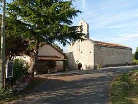
The village of Saint Sulpice consists of a collection of houses grouped around the church and overlooking the valley of the Tiarde and a collection of small hamlets: Le Roule at the edge of the town of Couture, les Fantins near Route of Champagne-Mouton-Chenon in the south of the commune, les Raffoux, Chez Bahuet near to the Tiarde, etc.
The commune of Saint-Sulpice-de-Ruffec is 10 miles southeast of Ruffec, there is one main road running through the commune the Aunac to Champagne-Mouton road
The soil is predominately clay.
Population
| Historical population | ||
|---|---|---|
| Year | Pop. | ±% |
| 1800 | 152 | — |
| 1841 | 282 | +85.5% |
| 1866 | 227 | −19.5% |
| 1886 | 161 | −29.1% |
| 1901 | 150 | −6.8% |
| 1921 | 121 | −19.3% |
| 1936 | 107 | −11.6% |
| 1954 | 102 | −4.7% |
| 1962 | 76 | −25.5% |
| 1968 | 83 | +9.2% |
| 1975 | 67 | −19.3% |
| 1982 | 50 | −25.4% |
| 1990 | 46 | −8.0% |
| 1999 | 35 | −23.9% |
| 2008 | 36 | +2.9% |
The population of Saint-Sulpice-de-Ruffec is now a mix of French nationals and British.
Economy
Agricultural: bovine and crops mainly maize, oil seed rape and sunflowers, diversification into raising of Alpaca s, for wool and breeding [1]
Sights
The village of Saint-Sulpice is centred on its 12th-century church. Directly outside the church is a war memorial dedicated to eight people who lost their lives in the first world war (1914–1918).
On the outskirts of the commune of Saint-Sulpice-de-Ruffec, there is a memorial to a French patriot Largeau Gilbert who was shot on 26 June 1944.
See also
References
- ↑ Farrlacey. "farm breeding alpacas in Saint-Sulpice-de-Ruffec", 2007. accessed 20 April 2010.
| Wikimedia Commons has media related to Saint-Sulpice-de-Ruffec. |