La Haye-d'Ectot
| La Haye-d'Ectot | |
|---|---|
|
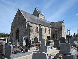
The church of Notre-Dame | |
 La Haye-d'Ectot | |
|
Location within Normandy region  La Haye-d'Ectot | |
| Coordinates: 49°23′34″N 1°43′50″W / 49.3928°N 1.7306°WCoordinates: 49°23′34″N 1°43′50″W / 49.3928°N 1.7306°W | |
| Country | France |
| Region | Normandy |
| Department | Manche |
| Arrondissement | Cherbourg-Octeville |
| Canton | Barneville-Carteret |
| Intercommunality | Communauté de communes de la Côte des Isles |
| Government | |
| • Mayor (2008–2014) | Gilbert Giot |
| Area1 | 7.32 km2 (2.83 sq mi) |
| Population (2006)2 | 220 |
| • Density | 30/km2 (78/sq mi) |
| Time zone | CET (UTC+1) |
| • Summer (DST) | CEST (UTC+2) |
| INSEE/Postal code | 50235 / 50270 |
| Elevation |
12–125 m (39–410 ft) (avg. 70 m or 230 ft) |
|
1 French Land Register data, which excludes lakes, ponds, glaciers > 1 km² (0.386 sq mi or 247 acres) and river estuaries. 2 Population without double counting: residents of multiple communes (e.g., students and military personnel) only counted once. | |
La Haye-d'Ectot is a commune in the Manche department in Normandy in north-western France.
See also
| Wikimedia Commons has media related to La Haye-d'Ectot. |
This article is issued from Wikipedia - version of the 8/16/2016. The text is available under the Creative Commons Attribution/Share Alike but additional terms may apply for the media files.