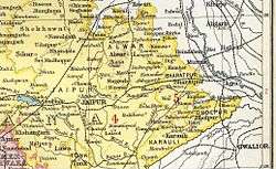
Karauli State
| Karauli State करौली रियासत | ||||||
| Princely State of British India | ||||||
| ||||||
| ||||||
 | ||||||
| History | ||||||
| • | Established | 1348 | ||||
| • | Indian independence | 1949 | ||||
| Area | ||||||
| • | 1931 | 3,216 km2 (1,242 sq mi) | ||||
| Population | ||||||
| • | 1931 | 140,525 | ||||
| Density | 43.7 /km2 (113.2 /sq mi) | |||||
| Today part of | Rajasthan, India | |||||
| | ||||||


Karauli State[1] was a princely state in India from 1348 to 1949. It was located in the Braj region. The main village in Karauli district is Mandrayal or Mandrail.
Geography
The state had an area of 3,178 km2 (1,227 sq mi). In 1901, the population of the state was 156,786, and that of the town was 23,482. Millets, the staple food of the people, was the main agricultural produce. As of the early 20th century, there were no major industries; a little weaving, dyeing, wood-turning and stone cutting constituted the notable cottage industries. Most goods, as also salt, sugar, cotton, buffaloes and bullocks, were imported; rice and goats comprised the main exports.
History
The predecessor state of the princely state of Karauli, the Kingdom of Mathura, was founded about 995 by Raja Bijai Pal a Yaduvanshi Rajput ruler.[2] Historical data point to Arjun Deo as the founder of the Karauli State in 1348. The capital was successively in the towns of Mathura, Dwarika, Bayana, Timan Garh, Andher Kotla, Mandrayal, U'ntgir and Bahadurpur.
In 1535 Bahadur Shah of Gujarat besieged the fort of Chittor, upon which Humayun himself started to fight against him. Rani Karnawati, the widow of Rana Sanga, was ruling Chittor as regent. She also tried to be friendly with the Mughals and sent a Rakhi to Humayun, but Humayun did not arrive in time. If he would have arrived in time and helped Karnawati, perhaps it would have been Sisodias as their close allies. However, Kachwahas became the first allies of Mughals in Rajputana. Bharmal's policy towards Mughals was merely an extension of his brother's policy.
Bharmal's eldest brother Raja Puranmal died at the Battle of Mandrail in 1534, while helping Humayun to recapture the fort of Bayana. He had a son named Surajmal or Sooja. But he was not recognized as king and his younger brother Raja Bhim Singh ascended to the throne of Amber. Bhim Singh was succeeded by his son Raja Ratan Singh and Raja Bharmal succeeded him in 1548.
British Raj
During the 18th century Karauli was under the Maratha Empire until the Marathas were defeated by the British. In 1817, Karauli's ruler signed a treaty with the East India Company and became a British protectorate, the status was maintained till the independence of India in 1947.
After India's independence in 1947, the state under Maharaja Ganesh Pal Deo acceded to the Dominion of India on 7 April 1949; Karauli later merged with the Union of India and became part of the state of Rajasthan.
Rulers
The rulers of the state bore the title 'Maharaja'. Karauli was ruled by Jadubansi Rajputs.[3][4]
Maharajas
- 1688 - 1724 Kunwar Pal II
- 1724 - 1757 Gopal Singh (d. 1757)
- 1757 - 24 Oct 1772 Tursam Pal (d. 1772)
- 1772 - 1804 Manik Pal
- 1804 - 1805 Amola Pal (d. 1805)
- 1805 - 1837 Herbaksh Pal (b. c.1792 - d. 1837)
- 1837 - 1849 Pratap Pal (d. 1849)
- 1849 - 10 Jul 1852 Narsingh Pal (d. 1852)
- 4 Sep 1852 - 14 Mar 1854 Bharat Pal
- 14 Mar 1854 - 16 Aug 1869 Madan Pal (d. 1869) (from 12 Feb 1866, Sir Madan Pal)
- 1869 Lakshman Pal
- 1869 - 17 Nov 1875 Jaisingh Pal (d. 1875)
- 1869 - 1871 Vrishbhan Singh Tanwar -Regent
- Jan 1876 - 14 Aug 1886 Arjun Pal II (d. 1886)
- 14 Aug 1886 - 3 Aug 1927 Bhanwar Pal (b. 1864 - d. 1927) (from 22 Jun 1897, Sir Bhanwar Pal)
- 3 Aug 1927 - 6 Apr 1947 Bhom Pal (b. 1866 - d. 1947) (from 1 Jan 1935, Sir Bhom Pal)
- 6 Apr 1947 - 15 Aug 1947 Ganesh Pal (b. 1906 - d. 1984)
See also
References
External links
- Revenue Stamps of the Princely State of Karauli Exhibit by Jiří Černý
Coordinates: 26°18′N 77°14′E / 26.3°N 77.23°E