Dholpur State
| Dholpur State धौलपुर रियासत | |||||
| Princely State of British India | |||||
| |||||
|
Flag | |||||
 | |||||
| History | |||||
| • | Established | c. 700 | |||
| • | Independence of India | 1949 | |||
| Area | |||||
| • | 1901 | 3,038 km2 (1,173 sq mi) | |||
| Population | |||||
| • | 1901 | 250,000 | |||
| Density | 82.3 /km2 (213.1 /sq mi) | ||||
| Today part of | Rajasthan, India | ||||

Dholpur State or Dhaulpur State was a kingdom of eastern Rajputana, India, which was founded in AD 1806 by a Hindu Jat Ruler.[1] After 1818 the state was placed under the authority of British India's Rajputana Agency. The Ranas ruled the state until the independence of India in 1947, when the kingdom was merged with the Union of India.
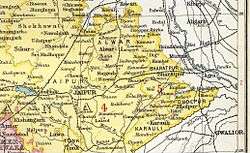
Dholpur princely state was located in the present-day state of Rajasthan. The state had an area of 3,038 km2 (1,173 sq mi), and an estimated revenue of Rs.83,000/-.
The current chief minister of Rajasthan, Vasundhara Raje, is a member of the erstwhile ruling family of Dholpur.
History
Very little is known of the early history of the state. According to tradition a predecessor state was established as Dhavalapura. In 1505 neighboring Gohad State was founded and between 1740 and 1756 Gohad was occupied by Gwalior State. From 1761 to 1775 Dholpur was annexed to Bharatpur State and between 1782 and December 1805 Dholpur was again annexed by Gwalior. On 10 January 1806 Dholpur became a British protectorate and in the same year the Ruler of Gohad merged Gohad into Dholpur.[2][3]
The last ruler of Dholpur signed the instrument of accession to the Indian Union on 7 April 1949.[4]
Rulers
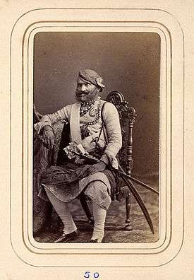
The rulers of the state were Hindu and were styled Maharaja from 1806 onwards.[2] They were entitled to a 15-gun salute.
Rulers of Gohad (title Rana)
- 1699 - 1713 Gaj Singh (d. 1713)
- 1713 - 1717 Jaswant Singh (d. 1717)
- 1717 - 1756 Bhim Singh (d. 1756)
- 1756 - 1757 Pratap Singh (d. 1757)
- 1757 - 1784 Chhatrapat Singh (d. 1788) (personal style Maharaj Rana from 1771)
- 1784 - 1804 Interregnum
- 1804 - 1806 Kirat Singh (b. 1763 - d. 1836)
Rulers of Dholpur (title Maharaja Rana)
- 1806 - 21 Apr 1836 Kirat Singh (s.a.)
- 1836 - Dec 1836 Pohap Singh (d. 1836)
- Dec 1836 - 7 Feb 1873 Bhagwant Singh (b. 1824 - d. 1873) (from 2 Jun 1869, Sir Bhagwant Singh)
- 7 Feb 1873 - 20 Jul 1901 Nihal Singh (b. 1863 - d. 1901)
- 7 Feb 1873 - 1884 Maharani Sateha Devi (b. 1845 - d. 1888) Bhawa (f) -Regent
- 20 Jul 1901 - 29 Mar 1911 Ram Singh (b. 1883 - d. 1911) (from 1 Jan 1909, Sir Ram Singh)
- 20 Jul 1901 - Mar 1905 .... -Regent
- 29 Mar 1911 - 15 Aug 1947 Udai Bhan Singh (b. 1893 - d. 1954) (from 1 Jan 1918, Sir Udai Bhan Singh)
- 29 Mar 1911 - 9 Oct 1913 .... -Regent
See also
References
- ↑ John Zubrzycki (2012). The Mysterious Mr Jacob. Random House India. p. 3. ISBN 9788184003369.
- 1 2 Princely States
- ↑ Gazetteer of India, v. 11, p. 323.
- ↑ Dholpur Princely State (15 gun salute)
External links
-
 Media related to Dholpur State at Wikimedia Commons
 - Genealogy of the rulers of Dholpur
- Princely States of India A-J
Template:Princely states of Rajputana
Coordinates: 26°42′N 77°54′E / 26.7°N 77.9°E