Delaware Valley
| Delaware Valley Greater Philadelphia Southeastern Pennsylvania Philadelphia-Camden-Wilmington, PA-NJ-DE-MD MSA | |||||
|---|---|---|---|---|---|
| Metropolitan Statistical Area | |||||
| |||||
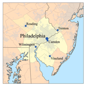 Map of the Lower Delaware Valley Metropolitan Area | |||||
| Country |
| ||||
| State |
- - - - | ||||
| Principal cities |
Philadelphia, Camden & Wilmington CSA: Reading, Trenton, Atlantic City, Vineland, Hammonton, Dover | ||||
| Area | |||||
| • Urban | 1,981.4 sq mi (5,131.7 km2) | ||||
| • Metro | 5,118 sq mi (13,256 km2) | ||||
| Elevation[1][2] | 0 - 1,080 ft (0 - 329 m) | ||||
| Population (2013 est.) | |||||
| • Density | 2,746.32/sq mi (1,060.36/km2) | ||||
| • Urban | 5,441,567 (5th) | ||||
| • MSA | 6,034,678 (6th) | ||||
| • CSA | 7,146,706 (8th) | ||||
| MSA/CSA = 2013, Urban = 2010 | |||||
| Time zone | EST (UTC-5) | ||||
| • Summer (DST) | EST (UTC-4) | ||||


The Delaware Valley is the valley through which the Delaware River flows. By extension, this toponym is commonly used to refer to the Philadelphia metropolitan area ("the [Lower] Delaware Valley Metropolitan Area"), which straddles the Lower Delaware River just north of its estuary.
Geography
In geology and geography, a strict sense of the term would incorporate the Delaware River's main drainage basin, and so encompass major tributaries such as the Schuylkill River and Lehigh River and their valleys or sub-basins. These extensions also apply culturally with decreasing degree gradually decreased by proximal distance because the ease of land travel enables a great deal of daily interaction; for example, the large number of commuters who travel daily 45–90 minutes creates cultural blends and parallel values.

Population and economy
The Delaware Valley Metropolitan Area is located at the southern part of the Northeast megalopolis extending from Boston to Washington, D.C. metropolitan areas.
The Delaware Valley Metropolitan Area is composed of several counties in eastern Pennsylvania and southwestern New Jersey, one county in northern Delaware and one county in northeastern Maryland. The MSA has a population of over 6 million, while the CSA has a population of over 7.1 million (as of the 2010 Census Bureau count). Philadelphia, being the region's major commercial, cultural, and industrial center, wields a rather large sphere of influence that affects the counties that immediately surround it.
As of March 2011, the Philadelphia–Camden–Wilmington, PA–NJ–DE–MD Metropolitan Statistical Area[3] constitutes the sixth-largest metropolitan area in the United States.[4][5][6] Its CSA ranks 8th.
Based on commuter flows, the OMB also defines a wider labor market region that adds Berks County, Pennsylvania to the Philadelphia–Camden–Wilmington metro area bringing the total metropolitan population to 6.53 million.
Philadelphia's media ranks fourth, behind New York City, Los Angeles, and Chicago, in Nielsen Media Market size rankings. It also borders the New York metropolitan area located directly to the north of this area.
Such educational institutions as Delaware Valley Regional High School in Alexandria Township and Delaware Valley College in Doylestown Township are named after the region. Likewise, Frenchtown's now defunct newspaper The Delaware Valley News was another example of the usage.
Counties making up the Delaware Valley
Delaware
- Kent County (Dover Metropolitan Area, in the CSA, not in the MSA [7])
- New Castle County
Maryland
New Jersey
- Atlantic County (Atlantic City-Hammonton Metropolitan Area, in the CSA, not in the MSA [7])
- Burlington County
- Camden County
- Cape May County (Ocean City Metropolitan Area, in the CSA, not in the MSA [7])
- Cumberland County (Vineland Metropolitan Area, in the CSA, not in the MSA [8])
- Gloucester County
- Salem County
- Mercer County (Trenton MSA, not in Philadelphia's CSA, considered part of the New York CSA)
Pennsylvania
- Berks County (Reading Metropolitan Area, in the CSA, not in the MSA [8])
- Bucks County
- Chester County
- Delaware County
- Montgomery County
- Philadelphia County
Principal cities
The following metropolitan areas (MSAs), other than the Trenton MSA, are included in the Combined Statistical Area (CSA). While Trenton is considered part of the Delaware Valley and often considered part of Philadelphia's market area, it is considered part of New York's CSA. The principal cities in each MSA are as follows:
Philadelphia–Camden–Wilmington Metropolitan Statistical Area (MSA)[8]
Reading Metropolitan Statistical Area (MSA)
Vineland–Millville–Bridgeton Metropolitan Statistical Area (MSA)
Atlantic City–Hammonton, New Jersey Metropolitan Statistical Area (MSA)[9]
Dover, Delaware Metropolitan Statistical Area (MSA)
Ocean City, New Jersey Metropolitan Statistical Area (MSA)
Trenton, New Jersey Metropolitan Statistical Area (MSA)
Characterics


The Delaware Valley is home to extensive populations of Irish Americans, German Americans, English Americans, Ukrainian Americans, Italian Americans, Polish Americans, Scottish Americans, Scotch-Irish Americans, Greek Americans, African Americans (over 40% of the city of Philadelphia's residents are black), Asians such as Chinese, Indian, Korean and Vietnamese, Armenians, Arabs and Turks, Indians and Pakistanis, Israelis (while American Jews form a significant ethno-religious community), Hispanics. Within the Hispanic population, the vast majority are Puerto Ricans, though other groups include Dominicans and Mexicans.[10] There is a significant West Indian community. There is even a small Native American community known as Lenapehoking for Lenni-Lenape Indians of West Philadelphia.
Philadelphia's suburbs contain a high concentration of malls, the two largest of which have at least 5,000,000 square feet (460,000 m2) of office space, and at least 600,000 square feet (56,000 m2) of retail. These are the King of Prussia Mall in King of Prussia, Pennsylvania, which is the largest in the United States (leasable sq. feet of retail space), and the Cherry Hill Mall in Cherry Hill Township, New Jersey, which was the first enclosed mall on the East Coast. Malls, office complexes, strip shopping plazas, expressways, and tract housing are common sights, and more and more continue to replace rolling countryside, farms, woods, and wetlands. However, due to strong opposition by residents and political officials, many acres of land have been preserved throughout the Delaware Valley. Older townships and large boroughs such as Cheltenham, Norristown, Jenkintown, Upper Darby and West Chester retain distinct community identities while engulfed in suburbia. The fastest-growing counties are Chester, Montgomery, Bucks, and Gloucester. Upper Darby, in Delaware County is the largest township in the United States. Sometimes Reading is included in the Delaware Valley Metro Area.
Climate
The Delaware Valley has four distinct seasons with ample precipitation and is divided by the 0 °C (32 °F) January isotherm. Most of Philadelphia and the NJ portion, almost all of the DE and MD portions, part of Delaware County, and extreme southern portions of Bucks and Chester Counties have a humid subtropical climate (Cfa.) The remainder of the Delaware Valley has a hot-summer humid continental climate (Dfa.) Snow amounts may vary widely year-to-year and normally do vary widely within the Delaware Valley. The region has only two ski areas: Bear Creek Ski and Recreation Area in eastern Berks County and Spring Mountain in central Montgomery County.
Using the -3 °C January isotherm as a boundary, all of the Delaware Valley is humid subtropical except for portions of Berks County and higher areas of northern Chester County. The warm-summer humid continental climate (Dfb) only exists in higher areas of Berks where all monthly temperatures average below 22 °C.
| Climate data for Philadelphia (Philadelphia Airport), 1981–2010 normals,[lower-alpha 1] extremes 1872–present[lower-alpha 2] | |||||||||||||
|---|---|---|---|---|---|---|---|---|---|---|---|---|---|
| Month | Jan | Feb | Mar | Apr | May | Jun | Jul | Aug | Sep | Oct | Nov | Dec | Year |
| Record high °F (°C) | 74 (23) |
79 (26) |
87 (31) |
95 (35) |
97 (36) |
102 (39) |
104 (40) |
106 (41) |
102 (39) |
96 (36) |
84 (29) |
73 (23) |
106 (41) |
| Mean maximum °F (°C) | 62.0 (16.7) |
62.7 (17.1) |
73.6 (23.1) |
83.2 (28.4) |
89.1 (31.7) |
94.2 (34.6) |
96.4 (35.8) |
94.7 (34.8) |
89.8 (32.1) |
81.7 (27.6) |
72.3 (22.4) |
63.5 (17.5) |
97.5 (36.4) |
| Average high °F (°C) | 40.3 (4.6) |
43.8 (6.6) |
52.7 (11.5) |
63.9 (17.7) |
73.8 (23.2) |
82.7 (28.2) |
87.1 (30.6) |
85.3 (29.6) |
78.0 (25.6) |
66.6 (19.2) |
56.0 (13.3) |
44.8 (7.1) |
64.6 (18.1) |
| Average low °F (°C) | 25.6 (−3.6) |
27.7 (−2.4) |
34.4 (1.3) |
44.1 (6.7) |
54.0 (12.2) |
63.8 (17.7) |
69.2 (20.7) |
67.9 (19.9) |
60.3 (15.7) |
48.4 (9.1) |
39.2 (4) |
30.1 (−1.1) |
47.1 (8.4) |
| Mean minimum °F (°C) | 8.7 (−12.9) |
12.7 (−10.7) |
19.4 (−7) |
31.6 (−0.2) |
42.0 (5.6) |
52.2 (11.2) |
59.8 (15.4) |
57.8 (14.3) |
47.2 (8.4) |
35.8 (2.1) |
26.0 (−3.3) |
15.8 (−9) |
6.4 (−14.2) |
| Record low °F (°C) | −7 (−22) |
−11 (−24) |
5 (−15) |
14 (−10) |
28 (−2) |
44 (7) |
51 (11) |
44 (7) |
35 (2) |
25 (−4) |
8 (−13) |
−5 (−21) |
−11 (−24) |
| Average precipitation inches (mm) | 3.03 (77) |
2.65 (67.3) |
3.79 (96.3) |
3.56 (90.4) |
3.71 (94.2) |
3.43 (87.1) |
4.35 (110.5) |
3.50 (88.9) |
3.78 (96) |
3.18 (80.8) |
2.99 (75.9) |
3.56 (90.4) |
41.53 (1,054.9) |
| Average snowfall inches (cm) | 6.5 (16.5) |
8.8 (22.4) |
2.9 (7.4) |
0.5 (1.3) |
0 (0) |
0 (0) |
0 (0) |
0 (0) |
0 (0) |
0 (0) |
0.3 (0.8) |
3.4 (8.6) |
22.4 (56.9) |
| Average precipitation days (≥ 0.01 in) | 10.6 | 9.4 | 10.5 | 11.3 | 11.1 | 9.8 | 9.9 | 8.4 | 8.7 | 8.6 | 9.3 | 10.6 | 118.2 |
| Average snowy days (≥ 0.1 in) | 4.4 | 3.6 | 1.8 | 0.4 | 0 | 0 | 0 | 0 | 0 | 0 | 0.2 | 1.8 | 12.2 |
| Average relative humidity (%) | 66.2 | 63.6 | 61.7 | 60.4 | 65.4 | 67.8 | 69.6 | 70.4 | 71.6 | 70.8 | 68.4 | 67.7 | 67.0 |
| Mean monthly sunshine hours | 155.7 | 154.7 | 202.8 | 217.0 | 245.1 | 271.2 | 275.6 | 260.1 | 219.3 | 204.5 | 154.7 | 137.7 | 2,498.4 |
| Percent possible sunshine | 52 | 52 | 55 | 55 | 55 | 61 | 61 | 61 | 59 | 59 | 52 | 47 | 56 |
| Source: NOAA (relative humidity and sun 1961–1990) [12][14][15] | |||||||||||||
| Climate data for Atlantic City, New Jersey (downtown), 1981–2010 normals,[lower-alpha 3] extremes 1874–present[lower-alpha 4] | |||||||||||||
|---|---|---|---|---|---|---|---|---|---|---|---|---|---|
| Month | Jan | Feb | Mar | Apr | May | Jun | Jul | Aug | Sep | Oct | Nov | Dec | Year |
| Record high °F (°C) | 72 (22) |
77 (25) |
84 (29) |
91 (33) |
95 (35) |
99 (37) |
102 (39) |
104 (40) |
94 (34) |
91 (33) |
80 (27) |
74 (23) |
104 (40) |
| Mean maximum °F (°C) | 59.3 (15.2) |
59.9 (15.5) |
68.4 (20.2) |
77.3 (25.2) |
83.7 (28.7) |
89.7 (32.1) |
93.5 (34.2) |
91.8 (33.2) |
86.3 (30.2) |
78.9 (26.1) |
70.1 (21.2) |
62.4 (16.9) |
95.3 (35.2) |
| Average high °F (°C) | 41.8 (5.4) |
43.5 (6.4) |
49.6 (9.8) |
57.6 (14.2) |
66.6 (19.2) |
75.7 (24.3) |
81.3 (27.4) |
80.2 (26.8) |
74.8 (23.8) |
65.0 (18.3) |
55.8 (13.2) |
46.3 (7.9) |
61.6 (16.4) |
| Average low °F (°C) | 29.2 (−1.6) |
30.9 (−0.6) |
36.9 (2.7) |
45.5 (7.5) |
54.5 (12.5) |
64.3 (17.9) |
70.0 (21.1) |
69.7 (20.9) |
63.5 (17.5) |
52.5 (11.4) |
42.9 (6.1) |
33.5 (0.8) |
49.5 (9.7) |
| Mean minimum °F (°C) | 11.3 (−11.5) |
16.3 (−8.7) |
22.4 (−5.3) |
33.8 (1) |
44.3 (6.8) |
53.7 (12.1) |
61.4 (16.3) |
60.1 (15.6) |
50.5 (10.3) |
39.2 (4) |
29.0 (−1.7) |
19.0 (−7.2) |
10.1 (−12.2) |
| Record low °F (°C) | −4 (−20) |
−9 (−23) |
8 (−13) |
15 (−9) |
33 (1) |
45 (7) |
52 (11) |
48 (9) |
37 (3) |
27 (−3) |
10 (−12) |
−7 (−22) |
−9 (−23) |
| Average precipitation inches (mm) | 3.08 (78.2) |
2.87 (72.9) |
4.02 (102.1) |
3.39 (86.1) |
3.22 (81.8) |
2.68 (68.1) |
3.31 (84.1) |
3.92 (99.6) |
3.08 (78.2) |
3.47 (88.1) |
3.35 (85.1) |
3.62 (91.9) |
40.01 (1,016.2) |
| Average snowfall inches (cm) | 4.5 (11.4) |
6.7 (17) |
1.1 (2.8) |
0.3 (0.8) |
0 (0) |
0 (0) |
0 (0) |
0 (0) |
0 (0) |
0 (0) |
0.2 (0.5) |
3.7 (9.4) |
16.5 (41.9) |
| Average precipitation days (≥ 0.01 in) | 9.3 | 9.0 | 10.5 | 10.9 | 10.4 | 8.7 | 8.4 | 8.0 | 7.7 | 7.6 | 8.9 | 10.4 | 109.8 |
| Average snowy days (≥ 0.1 in) | 2.9 | 2.8 | 0.9 | 0.3 | 0 | 0 | 0 | 0 | 0 | 0 | 0.1 | 1.7 | 8.7 |
| Average relative humidity (%) | 69.5 | 69.0 | 66.9 | 66.4 | 70.7 | 72.9 | 73.9 | 75.7 | 76.4 | 74.8 | 72.8 | 70.6 | 71.6 |
| Mean monthly sunshine hours | 150.8 | 157.9 | 204.5 | 218.9 | 243.9 | 266.2 | 276.3 | 271.3 | 227.6 | 200.5 | 147.4 | 133.8 | 2,499.1 |
| Percent possible sunshine | 50 | 53 | 55 | 55 | 55 | 60 | 61 | 64 | 61 | 58 | 49 | 46 | 56 |
| Source: NOAA (relative humidity and sun 1961–1990 and snow at Atlantic City Int'l)[17][18][12][19] | |||||||||||||
| Climate data for Doylestown, Pennsylvania | |||||||||||||
|---|---|---|---|---|---|---|---|---|---|---|---|---|---|
| Month | Jan | Feb | Mar | Apr | May | Jun | Jul | Aug | Sep | Oct | Nov | Dec | Year |
| Average high °F (°C) | 39 (4) |
43 (6) |
52 (11) |
63 (17) |
74 (23) |
82 (28) |
87 (31) |
85 (29) |
77 (25) |
66 (19) |
55 (13) |
44 (7) |
63.9 (17.8) |
| Average low °F (°C) | 24 (−4) |
25 (−4) |
33 (1) |
42 (6) |
52 (11) |
61 (16) |
66 (19) |
65 (18) |
57 (14) |
45 (7) |
37 (3) |
29 (−2) |
44.7 (7.1) |
| Average precipitation inches (mm) | 3.94 (100.1) |
2.87 (72.9) |
4.24 (107.7) |
3.85 (97.8) |
4.81 (122.2) |
3.61 (91.7) |
4.72 (119.9) |
4.34 (110.2) |
4.66 (118.4) |
3.35 (85.1) |
3.74 (95) |
3.80 (96.5) |
47.93 (1,217.4) |
| Source: Weather Channel [20] | |||||||||||||
| Climate data for Reading, Pennsylvania | |||||||||||||
|---|---|---|---|---|---|---|---|---|---|---|---|---|---|
| Month | Jan | Feb | Mar | Apr | May | Jun | Jul | Aug | Sep | Oct | Nov | Dec | Year |
| Record high °F (°C) | 71 (22) |
77 (25) |
88 (31) |
97 (36) |
96 (36) |
97 (36) |
102 (39) |
102 (39) |
100 (38) |
92 (33) |
82 (28) |
77 (25) |
102 (39) |
| Average high °F (°C) | 38 (3) |
42 (6) |
51 (11) |
63 (17) |
73 (23) |
82 (28) |
86 (30) |
84 (29) |
77 (25) |
66 (19) |
54 (12) |
43 (6) |
63.3 (17.4) |
| Average low °F (°C) | 22 (−6) |
24 (−4) |
32 (0) |
41 (5) |
51 (11) |
61 (16) |
65 (18) |
64 (18) |
56 (13) |
44 (7) |
36 (2) |
27 (−3) |
43.6 (6.4) |
| Record low °F (°C) | −20 (−29) |
−8 (−22) |
−2 (−19) |
16 (−9) |
26 (−3) |
39 (4) |
46 (8) |
42 (6) |
30 (−1) |
20 (−7) |
8 (−13) |
−4 (−20) |
−20 (−29) |
| Average precipitation inches (mm) | 2.92 (74.2) |
2.93 (74.4) |
3.56 (90.4) |
3.69 (93.7) |
4.03 (102.4) |
4.50 (114.3) |
4.67 (118.6) |
3.80 (96.5) |
4.42 (112.3) |
3.78 (96) |
3.44 (87.4) |
3.58 (90.9) |
45.32 (1,151.1) |
| Source: The Weather Channel[21] | |||||||||||||
| Climate data for Dover, Delaware (1981−2010 normals) | |||||||||||||
|---|---|---|---|---|---|---|---|---|---|---|---|---|---|
| Month | Jan | Feb | Mar | Apr | May | Jun | Jul | Aug | Sep | Oct | Nov | Dec | Year |
| Average high °F (°C) | 43.4 (6.3) |
47.0 (8.3) |
54.9 (12.7) |
65.7 (18.7) |
74.7 (23.7) |
83.2 (28.4) |
87.0 (30.6) |
85.2 (29.6) |
79.3 (26.3) |
68.8 (20.4) |
58.5 (14.7) |
47.4 (8.6) |
66.3 (19.1) |
| Average low °F (°C) | 27.1 (−2.7) |
29.0 (−1.7) |
35.6 (2) |
44.3 (6.8) |
53.8 (12.1) |
63.4 (17.4) |
68.4 (20.2) |
67.0 (19.4) |
60.1 (15.6) |
48.7 (9.3) |
39.8 (4.3) |
31.0 (−0.6) |
47.4 (8.6) |
| Average precipitation inches (mm) | 3.41 (86.6) |
3.07 (78) |
4.31 (109.5) |
3.88 (98.6) |
4.25 (108) |
4.00 (101.6) |
4.09 (103.9) |
4.36 (110.7) |
4.13 (104.9) |
3.42 (86.9) |
3.48 (88.4) |
3.65 (92.7) |
46.05 (1,169.8) |
| Average snowfall inches (cm) | 4.6 (11.7) |
7.7 (19.6) |
.3 (0.8) |
0 (0) |
0 (0) |
0 (0) |
0 (0) |
0 (0) |
0 (0) |
0 (0) |
.2 (0.5) |
2.9 (7.4) |
15.7 (40) |
| Average precipitation days (≥ 0.01 in) | 10.1 | 9.6 | 10.0 | 11.3 | 10.9 | 9.1 | 9.3 | 8.6 | 8.3 | 8.0 | 7.9 | 10.3 | 113.4 |
| Average snowy days (≥ 0.1 in) | 2.2 | 1.9 | .3 | 0 | 0 | 0 | 0 | 0 | 0 | 0 | 0 | .9 | 5.3 |
| Source: NOAA[22] | |||||||||||||
| Climate data for Wilmington, Delaware (New Castle Airport), 1981–2010 normals, extremes 1894–present | |||||||||||||
|---|---|---|---|---|---|---|---|---|---|---|---|---|---|
| Month | Jan | Feb | Mar | Apr | May | Jun | Jul | Aug | Sep | Oct | Nov | Dec | Year |
| Record high °F (°C) | 75 (24) |
78 (26) |
86 (30) |
97 (36) |
98 (37) |
102 (39) |
103 (39) |
107 (42) |
100 (38) |
94 (34) |
85 (29) |
75 (24) |
107 (42) |
| Average high °F (°C) | 40.2 (4.6) |
43.5 (6.4) |
52.4 (11.3) |
63.5 (17.5) |
73.0 (22.8) |
81.8 (27.7) |
86.1 (30.1) |
84.2 (29) |
77.4 (25.2) |
66.2 (19) |
55.7 (13.2) |
44.6 (7) |
64.1 (17.8) |
| Average low °F (°C) | 24.6 (−4.1) |
26.8 (−2.9) |
33.6 (0.9) |
43.0 (6.1) |
52.6 (11.4) |
62.6 (17) |
67.6 (19.8) |
66.1 (18.9) |
58.2 (14.6) |
46.1 (7.8) |
37.4 (3) |
28.7 (−1.8) |
45.6 (7.6) |
| Record low °F (°C) | −14 (−26) |
−15 (−26) |
2 (−17) |
11 (−12) |
30 (−1) |
40 (4) |
48 (9) |
43 (6) |
32 (0) |
23 (−5) |
11 (−12) |
−7 (−22) |
−15 (−26) |
| Average precipitation inches (mm) | 3.01 (76.5) |
2.68 (68.1) |
3.92 (99.6) |
3.50 (88.9) |
3.95 (100.3) |
3.88 (98.6) |
4.57 (116.1) |
3.25 (82.6) |
4.32 (109.7) |
3.42 (86.9) |
3.10 (78.7) |
3.48 (88.4) |
43.08 (1,094.2) |
| Average snowfall inches (cm) | 5.9 (15) |
8.3 (21.1) |
1.9 (4.8) |
0.3 (0.8) |
0 (0) |
0 (0) |
0 (0) |
0 (0) |
0 (0) |
0 (0) |
0.4 (1) |
3.4 (8.6) |
20.2 (51.3) |
| Average precipitation days (≥ 0.01 in) | 10.5 | 9.4 | 10.7 | 11.3 | 11.2 | 10.3 | 9.9 | 8.1 | 8.5 | 8.3 | 9.2 | 10.3 | 117.7 |
| Average snowy days (≥ 0.1 in) | 4.3 | 3.6 | 1.3 | 0.4 | 0 | 0 | 0 | 0 | 0 | 0 | 0.2 | 2.0 | 11.8 |
| Source: NOAA[12][23] | |||||||||||||
Colonial history
The valley was the territory of the Susquehannock and Lenape, who are recalled in place names throughout the region. The region became part of the Dutch colony of New Netherland after the exploration of Delaware Bay in 1609. The Dutch called the Delaware River the Zuyd Rivier, or South River, and considered the lands along it banks and those of its bay to be the southern flank of its province of New Netherland. In 1638, it began to be settled by Swedes, Forest Finns, Dutch, and Walloons and became the colony of New Sweden, though this was not officially recognized by the Dutch Empire who re-asserted control in 1655. The area was taken by the English in 1664.[24] The name Delaware comes from Thomas West, 3rd Baron De La Warr, who had arrived at Jamestown, Virginia in 1610, just as original settlers were about to abandon it, and thus maintaining the English foothold on the North American continent.
Transportation
Many residents commute to jobs in Philadelphia, Camden, and Wilmington with the help of expressways and trains. Commutes from one suburb to another are also common, as office parks have sprung up in new commercial centers such as King of Prussia, Fort Washington, Cherry Hill, and Plymouth Meeting.
Commuter rail
Formerly, the region was served by the Delaware Valley Railway.
- SEPTA Regional Rail
- Airport Line connecting Central Philadelphia with Philadelphia International Airport in Philadelphia and Delaware Counties.
- Wilmington/Newark Line connecting Philadelphia to the Wilmington, DE area (with limited weekday service to Newark, DE), via Chester City and Delaware County.
- Warminster Line connecting Philadelphia with southeastern Montgomery County and Warminster in Bucks County.
- West Trenton Line connecting Philadelphia north to the Trenton, NJ area, serving Montgomery and Bucks County, PA between Jenkintown, PA and Yardley, PA, with the final stop in Ewing, NJ.
- Media/Elwyn Line connecting Philadelphia to central Delaware County.
- Paoli/Thorndale Line connecting Philadelphia with the affluent Main Line area and western Chester County near Coatesville.
- Lansdale/Doylestown Line connecting Philadelphia with Lansdale in central Montgomery County and Doylestown in Bucks County.
- Manayunk/Norristown Line connecting Philadelphia with Conshohocken and Norristown in Montgomery County.
- Cynwyd Line connecting Philadelphia with Bala Cynwyd on the Philadelphia/Montgomery County line (limited weekday service)
- Trenton Line connecting Philadelphia to Trenton, NJ, serving Bucks County.
- Fox Chase Line connecting Central Philadelphia with the Fox Chase area in Philadelphia.
- Chestnut Hill East Line and Chestnut Hill West Line connecting Central Philadelphia with the Chestnut Hill area of the city.
- New Jersey Transit
- Atlantic City Line connecting Philadelphia to Atlantic City, NJ with connections to PATCO Speedline in Lindenwold, NJ.
- River Line connecting Camden (NJ) to Trenton (NJ) running along the east bank of the Delaware River.
- MARC
- Penn Line connecting Perryville, MD to Baltimore, MD and Washington D.C., and in the future will connect to SEPTA at Newark, DE.
- PATCO Speedline connecting Philadelphia to Lindenwold, NJ in Camden County with connections to NJT's Atlantic City Line.
Major highways

Pennsylvania
 I-76 (Schuylkill Expressway)
 I-78 / US 22
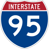 I-95 (Delaware Expressway)
 I-176
I-176
 I-76 / I-276 / Penna Turnpike
 I-476 (Blue Route)
- I-476 / Penna Turnpike NE Extension

 I-676 / US 30 (Vine Street Expressway)
 US 1 (Lincoln Expressway/Roosevelt Boulevard/City Line Avenue/Kennett-Oxford Bypass)
 US 13
US 13- US 30 (Lancaster Avenue/Lincoln Highway)
 US 202
 US 222 (Outer Bypass/Shillington Bypass)
 US 322
 US 422 (Pottstown Expressway/West Shore Bypass)
 PA 12 (Warren Street Bypass)
 PA 61 (Centre Avenue/Pottsville Pike)
 PA 63 (Woodhaven Road/Welsh Road)
 PA 100
 PA 309 (Fort Washington Expressway/Bethlehem Pike/Sellersville-Souderton Bypass)
 PA 611 (Doylestown Bypass)
New Jersey
 N.J. Turnpike
 G.S. Parkway
 A.C. Expressway
- I-76
 I-295
I-295- I-676 (North-South Freeway)
 US 9
US 9- US 30
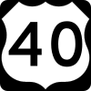 US 40
US 40 US 130
 US 206
- US 322
 Route 38
 Route 42 (North-South Freeway)
 Route 55
 Route 70
 Route 73
 Route 90
Delaware
Maryland
Delaware River Bridges
- New Hope–Lambertville Bridge[25]
- Scudder Falls Bridge (no toll)
- Delaware River – Turnpike Toll Bridge
- Burlington–Bristol Bridge
- Tacony–Palmyra Bridge
- Betsy Ross Bridge
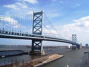
- Ben Franklin Bridge
- Walt Whitman Bridge
- Commodore Barry Bridge
- Delaware Memorial Bridge
Airports
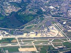
- Philadelphia International Airport (PHL)
- Northeast Philadelphia Airport (PNE)
- New Castle Airport (ILG)
- Reading Regional Airport (RDG)
- Atlantic City International Airport (ACY)
Colleges and universities
Delaware
- Delaware College of Art and Design
- Delaware State University
- Goldey-Beacom College
- University of Delaware
- Wesley College
- Widener University School of Law
- Wilmington University
New Jersey
- Stockton University
- Rowan University
- Rutgers School of Law–Camden
- Rutgers University (Camden)
- University of Medicine and Dentistry of New Jersey (Branch campuses in South Jersey)
- The College of New Jersey
Pennsylvania
- Albright College
- Alvernia University
- Arcadia University
- Bryn Mawr College
- Cabrini College
- Cairn University
- Chestnut Hill College
- Cheyney University of Pennsylvania
- Curtis Institute of Music
- Delaware Valley College
- DeVry University
- Drexel University
- Eastern University
- Gwynedd-Mercy College
- Harcum College
- Haverford College
- Holy Family University
- Immaculata University
- Kutztown University of Pennsylvania
- La Salle University
- Lincoln University
- Manor College
- Moore College of Art and Design
- Millersvile University
- Neumann University
- Peirce College
- Penn State Abington
- Penn State Berks
- Penn State Brandywine
- Penn State Great Valley
- Philadelphia College of Osteopathic Medicine
- Philadelphia University
- Rosemont College
- Saint Joseph's University
- Swarthmore College
- Temple University
- Thomas Jefferson University
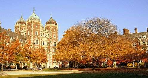
- University of Pennsylvania
- University of the Arts (Philadelphia)
- University of the Sciences in Philadelphia
- Ursinus College
- Valley Forge Christian College
- Valley Forge Military Academy and College
- Villanova University
- West Chester University
- Westminster Theological Seminary
- Widener University
Culture
Sports teams

Listing of the professional sports teams in the Delaware Valley
- National Basketball Association (NBA)
- Major League Baseball (MLB)
- Minor League Baseball (MiLB)
- National Football League (NFL)
- National Hockey League (NHL)
- Major League Soccer (MLS)
- Arena Football (AFL)
- NBA Developmental League (D-League)
Media
The two main newspapers are The Philadelphia Inquirer and the Philadelphia Daily News, owned by the Philadelphia Media Network. Local television channels include KYW-TV 3 (CBS), WPVI 6 (ABC), WCAU 10 (NBC), WHYY-TV 12 (PBS), WPHL-TV 17 (MyNetworkTV), WTXF 29 (FOX), WPSG 57 (CW), and WPPX 61 (Ion). Radio stations serving the area include: WRTI, WIOQ, WDAS (AM), and WTEL.
Area codes
- 215/267: The City of Philadelphia and its northern suburbs
- 610/484: Southeastern Pennsylvania outside Philadelphia, including the western suburbs, the Lehigh Valley, and most of Berks County
- 856: Southwestern New Jersey, including Camden, Cherry Hill, and Vineland
- 609: Central and Southeastern New Jersey, including Trenton, Atlantic City and the Jersey Shore
- 302: Delaware
- 410/443/667: Eastern half of Maryland, including Cecil County
- 717: South Central Pennsylvania, including Western Berks County
Lexicon note
Some believe that the term "Delaware Valley" is not entirely a synonym for "Greater Philadelphia". "Greater Philadelphia" implies that the region is centered on the city in an economic and cultural context, while "Delaware Valley" is a more generic geographic term that does not imply that any part is of more consequence than any other. Several organizations, such as KYW Radio and the Greater Philadelphia Tourism Marketing Corporation, consciously use the term "Greater Philadelphia" to assert that Philadelphia is the center of the region, referring to the less urbanized areas as "Philadelphia's countryside".[26] Others note that the customary media usage of the term omits the majority of the length of the Delaware River's valley that is not in metropolitan Philadelphia.
WPVI-TV uses the slogan, "The Delaware Valley's leading news program" for their Action News broadcast, since that program has led the ratings for news programs in the Philadelphia market for over 30 years.
See also
Notes
- ↑ Mean monthly maxima and minima (i.e. the highest and lowest temperature readings during an entire month or year) calculated based on data at said location from 1981 to 2010.
- ↑ Official temperature and precipitation measurements for Philadelphia were taken at the Weather Bureau Office in downtown from January 1872 to 19 June 1940, and at Philadelphia Int'l from 20 June 1940 to the present.[11] Snowfall and snow depth records date to 1 January 1884 and 1 October 1948, respectively.[12] In 2006, snowfall measurements were moved to National Park, New Jersey directly across the Delaware River from the airport.[13]
- ↑ Mean monthly maxima and minima (i.e. the highest and lowest temperature readings during an entire month or year) calculated based on data at said location from 1981 to 2010.
- ↑ The official climatology station for Atlantic City was at the Weather Bureau Office downtown from January 1874 to 15 June 1958 and Atlantic City Int'l (ACY) in Egg Harbor Township since 16 June 1958.[16] ACY's location in the Pine Barrens and distance away from the coast and urban heat island of downtown Atlantic City largely account for its markedly colder temperatures at night as compared to downtown; for example, from 1959 to 2013, there were 50 days with a low of 0 °F (−18 °C) or lower, while in the same period, the corresponding number of days at downtown was 2. The National Weather Service ceased regular snowfall observations at downtown after the winter of 1958–59.
References
- ↑ "Welsh Mountain". Retrieved May 5, 2016.
- ↑ "MyTopo – Welsh Mountain area". Retrieved May 5, 2016.
- ↑ "OMB BULLETIN NO. 13-01: Revised Delineations of Metropolitan Statistical Areas, Micropolitan Statistical Areas, and Combined Statistical Areas, and Guidance on Uses of the Delineations of These Areas" (PDF). Executive Office of the President -- Office of Management and Budget. February 28, 2013. Retrieved 2015-12-16.
37980 Philadelphia-Camden-Wilmington, PA-NJ-DE-MD Metropolitan Statistical Area
See also List of metropolitan areas of the United States and the sources there. - ↑ Thomas, G. Scott (March 7, 2011). "Houston 5th in metro population rankings, study shows".
- ↑ Metro area populations (as of March 7, 2011), Business First, March 22, 2011.
- ↑ Annual Metropolitan and Micropolitan Statistical Area Estimates
- 1 2 3 "OMB BULLETIN NO. 13-01" (PDF). Office of Management and Budget. February 28, 2013. Retrieved October 31, 2013.
- 1 2 3 OMB BULLETIN NO. 09-01
- ↑ http://www.whitehouse.gov/sites/default/files/omb/bulletins/2013/b13-01.pdf
- ↑ "Dominicans in the Delaware Valley". Medgar Evers College. Retrieved May 13, 2010.
- ↑ ThreadEx; search for location= "PA - Philadelphia", variable= "Station thread"
- 1 2 3 4 "NowData - NOAA Online Weather Data". National Oceanic and Atmospheric Administration. Retrieved 2011-12-14.
- ↑ Wood, Anthony R. "Snow total at airport gets a boost A new measuring station and technique likely contributed to two 8-inch-plus readings". Philly.com. The Inquirer. Retrieved 2014-06-10.
- ↑ "Station Name: PA PHILADELPHIA INTL AP". National Oceanic and Atmospheric Administration. Retrieved 2014-03-13.
- ↑ "WMO Climate Normals for PHILADELPHIA/INT'L ARPT PA 1961–1990". National Oceanic and Atmospheric Administration. Retrieved 2014-03-11.
- ↑ Threadex
- ↑ "Station Name: NJ ATLANTIC CITY". National Oceanic and Atmospheric Administration. Retrieved March 30, 2013.
- ↑ "Station Name: NJ ATLANTIC CITY INTL AP". National Oceanic and Atmospheric Administration. Retrieved 2014-03-14.
- ↑ "WMO Climate Normals for ATLANTIC CITY, NJ 1961–1990". National Oceanic and Atmospheric Administration. Retrieved 2014-03-11.
- ↑ Average weather for Doylestown Weather Channel Retrieved May 12, 2008
- ↑ "Climate Statistics for Reading, Pennsylvania". Retrieved March 10, 2012.
- ↑ "Station Name: DE DOVER". National Oceanic and Atmospheric Administration. Retrieved February 28, 2013.
- ↑ "Station Name: DE WILMINGTON NEW CASTLE CO AP". National Oceanic and Atmospheric Administration. Retrieved May 5, 2014.
- ↑
- ↑ "New Hope-Lambertville Route 202 Toll Bridge". Delaware River Joint Toll Brice Commission.
- ↑ Greater Philadelphia Tourism Marketing Corporation.
Further reading
- Jean R. Soderlund, Lenape Country: Delaware Valley Society before William Penn. Philadelphia: University of Pennsylvania Press, 2014.
- Mark L. Thompson, The Contest for the Delaware Valley: Allegiance, Identity, and Empire in the Seventeenth Century. Baton Rouge, LA: Louisiana State University Press, 2013.
External links
| Wikivoyage has a travel guide for Delaware Valley. |
| Wikimedia Commons has media related to Delaware Valley. |
| Counties | | |
|---|---|---|
| Major cities | ||
| Cities and towns 50k-99k | ||
| Cities and towns 30k-50k | ||
Dover (capital) | ||
| Topics |
|  |
| Society |
| |
| Cities | ||
| Towns |
| |
| Counties | ||
Coordinates: 39°52′37″N 75°19′23″W / 39.877°N 75.323°W