Memphis, Missouri
| Memphis, Missouri | |
|---|---|
| City | |
|
| |
 Location of Memphis, Missouri | |
| Coordinates: 40°27′39″N 92°10′12″W / 40.46083°N 92.17000°WCoordinates: 40°27′39″N 92°10′12″W / 40.46083°N 92.17000°W | |
| Country | United States |
| State | Missouri |
| County | Scotland |
| Area[1] | |
| • Total | 1.57 sq mi (4.07 km2) |
| • Land | 1.56 sq mi (4.04 km2) |
| • Water | 0.01 sq mi (0.03 km2) |
| Elevation | 801 ft (244 m) |
| Population (2010)[2] | |
| • Total | 1,822 |
| • Estimate (2012[3]) | 1,839 |
| • Density | 1,200/sq mi (450/km2) |
| Time zone | Central (CST) (UTC-6) |
| • Summer (DST) | CDT (UTC-5) |
| ZIP code | 63555 |
| Area code(s) | 660 |
| FIPS code | 29-47270 [4] |
| GNIS feature ID | 0722228 [5] |
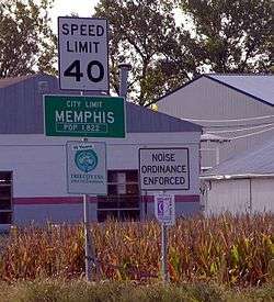
Memphis is a city in Scotland County, Missouri, United States. The population was 1,822 at the 2010 census. It is the county seat of Scotland County.[6] Memphis is located adjacent to U.S. Highway 136, east of Lancaster, and west of Kahoka.
History

Although Scotland County was organized by an act of the Missouri General Assembly on January 29, 1841 the town of Memphis did not come to be until more than two years later. County commissioners met at Sand Hill on May 15, 1843 to select the county seat. A spot near the geographical center of the county was chosen, and after some debate, was named Memphis,[7] after the ancient city of Memphis, Egypt.[8] The name had been previously used by a U.S. Post Office that operated on the North Fabius River a short distance away. The land for the town, about fifty acres, was donated to the county by early settler Samuel Cecil. After being laid out in town lots the original plat of Memphis was filed with county court on October 11, 1843.[7] However a few homes already existed on the site and had for several years, the first being a log cabin constructed in 1835 by Burton Tompkins.
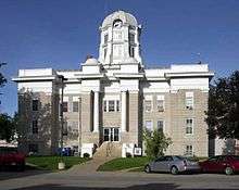
Scotland County's first courthouse, a two-story brick structure, was completed in June, 1845 at a cost of $1,500 dollars.[9] However just a decade later the building was declared unsafe by the county court and a second, larger courthouse was constructed in the middle of the town square in 1856 at a cost of $19,500. The second building served the county well until the turn of the 20th century, but at just forty feet by seventy feet it was becoming increasingly cramped. It was condemned in May, 1905 and razed in early 1907.[9] The current Scotland County courthouse was constructed between October, 1907 and July, 1908 at a cost of $50,000.
Civil War
Scotland County was the scene of two notable engagements during the American Civil War. On July 13, 1862 Confederate Colonel Joseph C. Porter approached Memphis in four converging columns totalling 125–169 men and captured it with little or no resistance.[10] They first raided the Federal armory, seizing about a hundred muskets with cartridge boxes and ammunition, and several uniforms. The Confederate rounded up all adult males, who were taken to the court house to swear not to divulge any information about the raiders for forty-eight hours. Porter freed all militiamen or suspected militiamen to await parole, a fact noted by champions of his character. Citizens expressed their sympathies variously; Porter gave safe passage to a physician, an admitted supporter of the Union, who was anxious to return to his seriously ill wife. A verbally abusive woman was threatened with a pistol by one of Porter’s troops, perhaps as a bluff. Porter’s troops entered the courthouse and destroyed all indictments for horse-theft; the act is variously understood as simple lawlessness, intervention on behalf of criminal associates, or interference with politically motivated, fraudulent charges.[10]
At Memphis, a key incident occurred which would darken Colonel Porter’s reputation, and which his detractors see as part of a consistent behavioral pattern which put him and his men beyond the norms of warfare. According to the "History of Shelby County,” which is generally sympathetic to Porter, “Most conceded that Col. Porter’s purpose for capturing Memphis, MO. was to seize Dr. Wm. Aylward, a prominent Union man of the community.” Aylward was captured during the day by Captain Tom Stacy's men and confined to a house. Stacy was generally regarded as a genuine bushwhacker, with his company called "the chain gang" by the other members of Porter's command due to their behavior. After rousing Doctor Aylward overnight and removing him from his home, ostensibly to see Porter, guards claimed that he escaped. However, witnesses reported hearing the sounds of a strangling, and his body was found the next day, with marks consistent with hanging or strangulation.[10] Supporters of Porter attribute the murder of Aylward to Stacy. However, a Union gentleman who came to inquire about Aylward and a captured officer before the discovery of the body stated that when he asked Porter about Aylward, the response was, "He is where he will never disturb anybody else."[10]
20th century
In the late 1920s, Memphis was the birthplace of The Pheasant Aircraft Company.
Geography
Memphis is located at 40°27′39″N 92°10′12″W / 40.46083°N 92.17000°W (40.460889, -92.169908),[11] along the North Fabius River. According to the United States Census Bureau, the city has a total area of 1.57 square miles (4.07 km2), of which, 1.56 square miles (4.04 km2) is land and 0.01 square miles (0.03 km2) is water.[1]
Demographics
| Historical population | |||
|---|---|---|---|
| Census | Pop. | %± | |
| 1850 | 183 | — | |
| 1870 | 1,007 | — | |
| 1880 | 1,418 | 40.8% | |
| 1890 | 1,780 | 25.5% | |
| 1900 | 2,195 | 23.3% | |
| 1910 | 1,984 | −9.6% | |
| 1920 | 1,941 | −2.2% | |
| 1930 | 1,728 | −11.0% | |
| 1940 | 1,935 | 12.0% | |
| 1950 | 2,035 | 5.2% | |
| 1960 | 2,106 | 3.5% | |
| 1970 | 2,081 | −1.2% | |
| 1980 | 2,105 | 1.2% | |
| 1990 | 2,094 | −0.5% | |
| 2000 | 2,061 | −1.6% | |
| 2010 | 1,822 | −11.6% | |
| Est. 2015 | 1,829 | [12] | 0.4% |
2010 census
As of the census[2] of 2010, there were 1,822 people, 813 households, and 466 families residing in the city. The population density was 1,167.9 inhabitants per square mile (450.9/km2). There were 994 housing units at an average density of 637.2 per square mile (246.0/km2). The racial makeup of the city was 98.5% White, 0.2% African American, 0.5% Native American, 0.1% Asian, 0.1% from other races, and 0.8% from two or more races. Hispanic or Latino of any race were 0.2% of the population.
There were 813 households of which 27.2% had children under the age of 18 living with them, 41.5% were married couples living together, 10.9% had a female householder with no husband present, 4.9% had a male householder with no wife present, and 42.7% were non-families. 39.1% of all households were made up of individuals and 20% had someone living alone who was 65 years of age or older. The average household size was 2.15 and the average family size was 2.85.
The median age in the city was 43.8 years. 24% of residents were under the age of 18; 7.3% were between the ages of 18 and 24; 20.2% were from 25 to 44; 25.1% were from 45 to 64; and 23.3% were 65 years of age or older. The gender makeup of the city was 44.6% male and 55.4% female.
2000 census
As of the census[4] of 2000, there were 2,061 people, 888 households, and 523 families residing in the city. The population density was 1,316.1 people per square mile (506.9/km²). There were 1,052 housing units at an average density of 671.8/sq mi (258.7/km²). The racial makeup of the city was 98.88% White, 0.19% Native American, 0.15% Asian, 0.15% from other races, and 0.63% from two or more races. Hispanic or Latino of any race were 0.53% of the population.
There were 888 households out of which 25.9% had children under the age of 18 living with them, 47.0% were married couples living together, 9.2% had a female householder with no husband present, and 41.1% were non-families. 36.8% of all households were made up of individuals and 21.7% had someone living alone who was 65 years of age or older. The average household size was 2.18 and the average family size was 2.87.
In the city the population was spread out with 23.0% under the age of 18, 7.8% from 18 to 24, 21.6% from 25 to 44, 19.1% from 45 to 64, and 28.5% who were 65 years of age or older. The median age was 43 years. For every 100 females there were 79.4 males. For every 100 females age 18 and over, there were 73.6 males.
The median income for a household in the city was $24,508, and the median income for a family was $33,750. Males had a median income of $21,947 versus $17,134 for females. The per capita income for the city was $16,220. About 15.2% of families and 17.6% of the population were below the poverty line, including 22.8% of those under age 18 and 16.2% of those age 65 or over.
Notable people
- Alexandre Hogue, Realist painter, known mostly for landscapes
- Tom Horn, range detective, gunfighter, outlaw
- George Saling, track & field athlete, gold medal winner at 1932 Summer Olympics
- Adrienne Wilkinson, TV, film and voiceover actress; notable roles on Xena: Warrior Princess and As If.
Gallery
 North side of the Memphis square. September, 2012.
 East side of the Memphis square. September, 2012.
 South side of the Memphis square. September, 2012.
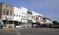 West side of the Memphis square. September, 2012.
References
- 1 2 "US Gazetteer files 2010". United States Census Bureau. Retrieved 2012-07-08.
- 1 2 "American FactFinder". United States Census Bureau. Retrieved 2012-07-08.
- ↑ "Population Estimates". United States Census Bureau. Retrieved 2013-05-30.
- 1 2 "American FactFinder". United States Census Bureau. Retrieved 2008-01-31.
- ↑ "US Board on Geographic Names". United States Geological Survey. 2007-10-25. Retrieved 2008-01-31.
- ↑ "Find a County". National Association of Counties. Retrieved 2011-06-07.
- 1 2 History of Knox and Scotland Counties, Missouri. St. Louis & Chicago: Goodspeed Publishing Company. 1887.
- ↑ Eaton, David Wolfe (1918). How Missouri Counties, Towns and Streams Were Named. The State Historical Society of Missouri. p. 362.
- 1 2 Ohman, Marian M. "Scotland County Courthouse". University of Missouri Extension. Retrieved 30 September 2012.
- 1 2 3 4 Mudd, Joseph A. (1889). With Porter in North Missouri. Washington, D.C.: The National Publishing Company. pp. 72–90.
- ↑ "US Gazetteer files: 2010, 2000, and 1990". United States Census Bureau. 2011-02-12. Retrieved 2011-04-23.
- ↑ "Annual Estimates of the Resident Population for Incorporated Places: April 1, 2010 to July 1, 2015". Retrieved July 2, 2016.
- ↑ "Census of Population and Housing". Census.gov. Retrieved June 4, 2015.
External links
| Wikisource has the text of a 1920 Encyclopedia Americana article about Memphis, Missouri. |
- Historic maps of Memphis in the Sanborn Maps of Missouri Collection at the University of Missouri
Municipalities and communities of Scotland County, Missouri, United States | ||
|---|---|---|
| Cities |  | |
| Villages | ||
| Townships |
| |
| Unincorporated community | ||