Edina, Missouri
| Edina, Missouri | |
|---|---|
| City | |
 Location of Edina, Missouri | |
| Coordinates: 40°10′8″N 92°10′24″W / 40.16889°N 92.17333°WCoordinates: 40°10′8″N 92°10′24″W / 40.16889°N 92.17333°W | |
| Country | United States |
| State | Missouri |
| County | Knox |
| Area[1] | |
| • Total | 1.32 sq mi (3.42 km2) |
| • Land | 1.31 sq mi (3.39 km2) |
| • Water | 0.01 sq mi (0.03 km2) |
| Elevation | 814 ft (248 m) |
| Population (2010)[2] | |
| • Total | 1,176 |
| • Estimate (2012[3]) | 1,160 |
| • Density | 897.7/sq mi (346.6/km2) |
| Time zone | Central (CST) (UTC-6) |
| • Summer (DST) | CDT (UTC-5) |
| ZIP code | 63537 |
| Area code(s) | 660 |
| FIPS code | 29-21322[4] |
| GNIS feature ID | 0717404[5] |
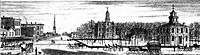
Edina is a city in Knox County, Missouri, United States, between the North and South Forks of the South Fabius River. The population was 1,176 at the 2010 census. It is the county seat of Knox County.[6]
Geography
Edina is located at 40°10′8″N 92°10′24″W / 40.16889°N 92.17333°W (40.168881, -92.173275).[7] According to the United States Census Bureau, the city has a total area of 1.32 square miles (3.42 km2), of which, 1.31 square miles (3.39 km2) is land and 0.01 square miles (0.03 km2) is water.[1]
History
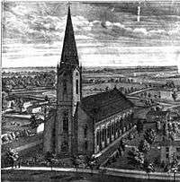
Edina was platted in 1839.[8] The community was named after the Scottish city of Edinburgh, as referred to by Scots poets.[9] A post office called Edina has been in operation since 1850.[10]
Demographics
| Historical population | |||
|---|---|---|---|
| Census | Pop. | %± | |
| 1850 | 163 | — | |
| 1870 | 807 | — | |
| 1880 | 1,156 | 43.2% | |
| 1890 | 1,456 | 26.0% | |
| 1900 | 1,605 | 10.2% | |
| 1910 | 1,526 | −4.9% | |
| 1920 | 1,438 | −5.8% | |
| 1930 | 1,532 | 6.5% | |
| 1940 | 1,637 | 6.9% | |
| 1950 | 1,607 | −1.8% | |
| 1960 | 1,457 | −9.3% | |
| 1970 | 1,574 | 8.0% | |
| 1980 | 1,520 | −3.4% | |
| 1990 | 1,283 | −15.6% | |
| 2000 | 1,233 | −3.9% | |
| 2010 | 1,176 | −4.6% | |
| Est. 2015 | 1,108 | [11] | −5.8% |
2010 census
As of the census[2] of 2010, there were 1,176 people, 535 households, and 312 families residing in the city. The population density was 897.7 inhabitants per square mile (346.6/km2). There were 667 housing units at an average density of 509.2 per square mile (196.6/km2). The racial makeup of the city was 98.6% White, 0.4% African American, 0.4% Native American, 0.1% Asian, and 0.4% from two or more races. Hispanic or Latino of any race were 0.6% of the population.
There were 535 households of which 25.0% had children under the age of 18 living with them, 43.9% were married couples living together, 12.1% had a female householder with no husband present, 2.2% had a male householder with no wife present, and 41.7% were non-families. 38.3% of all households were made up of individuals and 20.4% had someone living alone who was 65 years of age or older. The average household size was 2.14 and the average family size was 2.84.
The median age in the city was 46 years. 22.7% of residents were under the age of 18; 5.6% were between the ages of 18 and 24; 19.8% were from 25 to 44; 28% were from 45 to 64; and 24.1% were 65 years of age or older. The gender makeup of the city was 46.0% male and 54.0% female.
2000 census
As of the census[4] of 2000, there were 1,233 people, 571 households, and 339 families residing in the city. The population density was 940.7 people per square mile (363.4/km²). There were 678 housing units at an average density of 517.3/sq mi (199.8/km²). The racial makeup of the city was 97.16% White, 0.08% African American, 0.08% Native American, 0.16% Asian, 0.16% from other races, and 2.35% from two or more races. Hispanic or Latino of any race were 0.65% of the population.
There were 571 households out of which 22.9% had children under the age of 18 living with them, 47.1% were married couples living together, 9.6% had a female householder with no husband present, and 40.6% were non-families. 38.9% of all households were made up of individuals and 21.5% had someone living alone who was 65 years of age or older. The average household size was 2.11 and the average family size was 2.78.
In the city the population was spread out with 22.4% under the age of 18, 5.6% from 18 to 24, 21.5% from 25 to 44, 23.6% from 45 to 64, and 26.9% who were 65 years of age or older. The median age was 45 years. For every 100 females there were 86.0 males. For every 100 females age 18 and over, there were 82.6 males.
The median income for a household in the city was $24,900, and the median income for a family was $30,938. Males had a median income of $21,492 versus $16,458 for females. The per capita income for the city was $12,863. About 15.1% of families and 19.1% of the population were below the poverty line, including 29.7% of those under age 18 and 19.3% of those age 65 or over.
Weather
According weather data tallied between July 1, 1985 and June 30, 2015 for every location in the National Oceanic and Atmospheric Administration's official climate database, Edina, Missouri, is the snowiest place in the state of Missouri with an average of 22 inches of snow per year. [13]
Notable natives
- Terry Joyce, College football All-American & professional football player.
- George Turner, United States Senator
References
- 1 2 "US Gazetteer files 2010". United States Census Bureau. Retrieved 2012-07-08.
- 1 2 "American FactFinder". United States Census Bureau. Retrieved 2012-07-08.
- ↑ "Population Estimates". United States Census Bureau. Retrieved 2013-05-30.
- 1 2 "American FactFinder". United States Census Bureau. Retrieved 2008-01-31.
- ↑ "US Board on Geographic Names". United States Geological Survey. 2007-10-25. Retrieved 2008-01-31.
- ↑ "Find a County". National Association of Counties. Retrieved 2011-06-07.
- ↑ "US Gazetteer files: 2010, 2000, and 1990". United States Census Bureau. 2011-02-12. Retrieved 2011-04-23.
- ↑ "Knox County Place Names, 1928–1945 (archived)". The State Historical Society of Missouri. Retrieved 23 October 2016.
- ↑ Gannett, Henry (1905). The Origin of Certain Place Names in the United States. Govt. Print. Off. p. 114.
- ↑ "Post Offices". Jim Forte Postal History. Retrieved 23 October 2016.
- ↑ "Annual Estimates of the Resident Population for Incorporated Places: April 1, 2010 to July 1, 2015". Retrieved July 2, 2016.
- ↑ "Census of Population and Housing". Census.gov. Retrieved June 4, 2015.
- ↑ "The Snowiest Place in Each State". Retrieved 2015-01-24.
External links
| Wikimedia Commons has media related to Edina, Missouri. |
- Historic maps of Edina in the Sanborn Maps of Missouri Collection at the University of Missouri
Municipalities and communities of Knox County, Missouri, United States | ||
|---|---|---|
| Cities | 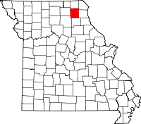 | |
| Villages | ||
| Townships | ||
| CDP | ||
| Unincorporated communities | ||
| Ghost town | ||