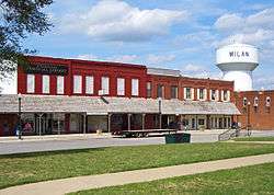
Milan, Missouri
| Milan, Missouri | |
|---|---|
| City | |
 | |
 Location of Milan, Missouri | |
| Coordinates: 40°12′6″N 93°7′30″W / 40.20167°N 93.12500°WCoordinates: 40°12′6″N 93°7′30″W / 40.20167°N 93.12500°W | |
| Country | United States |
| State | Missouri |
| County | Sullivan |
| Area[1] | |
| • Total | 1.78 sq mi (4.61 km2) |
| • Land | 1.77 sq mi (4.58 km2) |
| • Water | 0.01 sq mi (0.03 km2) |
| Elevation | 974 ft (297 m) |
| Population (2010)[2] | |
| • Total | 1,960 |
| • Estimate (2012[3]) | 1,909 |
| • Density | 1,107.3/sq mi (427.5/km2) |
| Time zone | Central (CST) (UTC-6) |
| • Summer (DST) | CDT (UTC-5) |
| ZIP code | 63556 |
| Area code(s) | 660 |
| FIPS code | 29-48062[4] |
| GNIS feature ID | 0722309[5] |
Milan is a city in Sullivan County, Missouri, United States. The population was 1,960 at the 2010 census. It is the county seat of Sullivan County.[6] It is pronounced MY-lun.
Geography


Milan is located at 40°12′6″N 93°7′30″W / 40.20167°N 93.12500°W (40.201661, -93.125092).[7] According to the United States Census Bureau, the city has a total area of 1.78 square miles (4.61 km2), of which, 1.77 square miles (4.58 km2) is land and 0.01 square miles (0.03 km2) is water.[1]
History
Excerpts from The Milan Standard of June 8, 1905
Marshall Baker Witter moved to Sullivan County in 1844. At that time Milan was known as the Pharsalia Post Office. The name was so hard to pronounce and so few people knew how to spell it that Mr. Witter sought an easier name.
In his youth, having read the noted Milan Decree, a treaty among certain European countries he suggested the name Milan for the city, and it was unanimously adopted. After which, by act of the legislature, approved February 9, 1859, Milan was incorporated.
R. D. Morrison was the first mayor of Milan. Mr. Witter was the second mayor, and during his second year as mayor, the legislature repealed the city charter. This act was approved by the governor February 8, 1861. From this time until the meeting of the county court in May 1867, the town was devoid of any form of government. The town remained unincorporated until 1869, when it was again incorporated.
Demographics
| Historical population | |||
|---|---|---|---|
| Census | Pop. | %± | |
| 1870 | 319 | — | |
| 1880 | 1,117 | 250.2% | |
| 1890 | 1,234 | 10.5% | |
| 1900 | 1,757 | 42.4% | |
| 1910 | 2,191 | 24.7% | |
| 1920 | 2,395 | 9.3% | |
| 1930 | 2,002 | −16.4% | |
| 1940 | 2,016 | 0.7% | |
| 1950 | 1,972 | −2.2% | |
| 1960 | 1,670 | −15.3% | |
| 1970 | 1,794 | 7.4% | |
| 1980 | 1,947 | 8.5% | |
| 1990 | 1,767 | −9.2% | |
| 2000 | 1,958 | 10.8% | |
| 2010 | 1,960 | 0.1% | |
| Est. 2015 | 1,852 | [8] | −5.5% |
2010 census
As of the census[2] of 2010, there were 1,960 people, 746 households, and 462 families residing in the city. The population density was 1,107.3 inhabitants per square mile (427.5/km2). There were 845 housing units at an average density of 477.4 per square mile (184.3/km2). The racial makeup of the city was 74.7% White, 0.6% African American, 0.4% Native American, 0.3% Asian, 0.4% Pacific Islander, 22.4% from other races, and 1.2% from two or more races. Hispanic or Latino of any race were 45.3% of the population.
There were 746 households of which 36.6% had children under the age of 18 living with them, 41.6% were married couples living together, 12.3% had a female householder with no husband present, 8.0% had a male householder with no wife present, and 38.1% were non-families. 31.5% of all households were made up of individuals and 15.6% had someone living alone who was 65 years of age or older. The average household size was 2.56 and the average family size was 3.24.
The median age in the city was 32.9 years. 28.1% of residents were under the age of 18; 9.6% were between the ages of 18 and 24; 28.4% were from 25 to 44; 21.7% were from 45 to 64; and 12.4% were 65 years of age or older. The gender makeup of the city was 50.0% male and 50.0% female.
2000 census
As of the census[4] of 2000, there were 1,958 people, 782 households, and 477 families residing in the city. The population density was 1,068.4 people per square mile (413.1/km²). There were 857 housing units at an average density of 467.6/sq mi (180.8/km²). The racial makeup of the city was 89.12% White, 0.10% African American, 0.36% Native American, 0.15% Asian, 0.10% Pacific Islander, 8.63% from other races, and 1.53% from two or more races. Hispanic or Latino of any race were 21.86% of the population.
There were 782 households out of which 29.7% had children under the age of 18 living with them, 44.0% were married couples living together, 12.5% had a female householder with no husband present, and 38.9% were non-families. 33.8% of all households were made up of individuals and 19.7% had someone living alone who was 65 years of age or older. The average household size was 2.44 and the average family size was 3.08.
In the city the population was spread out with 25.9% under the age of 18, 8.9% from 18 to 24, 26.8% from 25 to 44, 20.2% from 45 to 64, and 18.2% who were 65 years of age or older. The median age was 36 years. For every 100 females there were 95.2 males. For every 100 females age 18 and over, there were 90.9 males.
The median income for a household in the city was $20,691, and the median income for a family was $26,429. Males had a median income of $22,885 versus $15,491 for females. The per capita income for the city was $10,688. About 16.7% of families and 22.9% of the population were below the poverty line, including 27.5% of those under age 18 and 30.0% of those age 65 or over.
Notable residents
- Steve Riker - drummer for Head East (1991–1994)
- Cal Hubbard - Pro Football Hall of Famer, former MLB umpire and the only person inducted in both the football and baseball Hall of Fames.
- Whitley Schnelle -
References
- 1 2 "US Gazetteer files 2010". United States Census Bureau. Retrieved 2012-07-08.
- 1 2 "American FactFinder". United States Census Bureau. Retrieved 2012-07-08.
- ↑ "Population Estimates". United States Census Bureau. Retrieved 2013-05-30.
- 1 2 "American FactFinder". United States Census Bureau. Retrieved 2008-01-31.
- ↑ "US Board on Geographic Names". United States Geological Survey. 2007-10-25. Retrieved 2008-01-31.
- ↑ "Find a County". National Association of Counties. Retrieved 2011-06-07.
- ↑ "US Gazetteer files: 2010, 2000, and 1990". United States Census Bureau. 2011-02-12. Retrieved 2011-04-23.
- ↑ "Annual Estimates of the Resident Population for Incorporated Places: April 1, 2010 to July 1, 2015". Retrieved July 2, 2016.
- ↑ "Census of Population and Housing". Census.gov. Retrieved June 4, 2015.
External links
- Historic maps of Milan in the Sanborn Maps of Missouri Collection at the University of Missouri
-
 "Milan, Mo". Encyclopedia Americana. 1920.
Municipalities and communities of Sullivan County, Missouri, United States | ||
|---|---|---|
| Cities | 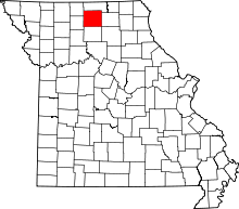 | |
| Villages | ||
| CDP | ||
| Unincorporated communities | ||
| Footnotes | ‡This populated place also has portions in an adjacent county or counties | |