West Plains, Missouri
| West Plains, Missouri | |
|---|---|
| City | |
|
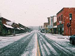
Looking north toward Court Square in December 2014 | |
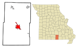 Location within Howell County and Missouri | |
| Coordinates: 36°44′14″N 91°51′54″W / 36.73722°N 91.86500°WCoordinates: 36°44′14″N 91°51′54″W / 36.73722°N 91.86500°W | |
| Country | United States |
| State | Missouri |
| County | Howell |
| First settled | 1838[1] |
| Incorporated (city) | 1883[2] |
| Founded by | Josiah Howell |
| Named for | Location on a prairie west of the nearest town[1] |
| Government | |
| • Type | Mayor-council |
| • Mayor | Jack Pahlmann (R)[3] |
| • City council |
Members
|
| Area[4] | |
| • Total | 13.33 sq mi (34.52 km2) |
| • Land | 13.31 sq mi (34.47 km2) |
| • Water | 0.02 sq mi (0.05 km2) 0.15% |
| • μSA | 928.33 sq mi (2,404.4 km2) |
| Elevation | 1,004 ft (306 m) |
| Population (2010)[5] | |
| • Total | 11,986 |
| • Estimate (2014[6]) | 12,275 |
| • Density | 900/sq mi (350/km2) |
| Time zone | Central Standard Time (UTC-6) |
| • Summer (DST) | Central Daylight Time (UTC-5) |
| Zip code | 65775 |
| Area code(s) | 417 |
| FIPS code | 29-78928 [7] |
| GNIS feature ID | 0740027 [8] |
| Website | westplains.net |
West Plains is a city in Howell County, Missouri, United States. The population was 11,986 at the 2010 Census. It is the county seat of Howell County.[9]
History
The history of West Plains can be traced back to 1832, when settler Josiah Howell (after whom Howell County is named) created the first settlement in the region known as Howell Valley. West Plains was so named because the settlement was on a prairie in a westerly direction from the nearest town.[10]
The American Civil War
The location of West Plains led to nearly constant conflict due to the proximity to what was then the border between the Union and Confederacy. West Plains was largely burned to the ground, and Howell County as a whole was devastated. No major battles occurred in West Plains or Howell County, but much of the devastation came from constant guerrilla warfare.
Confederate Brigadier General James Haggin McBride gave residents an ultimatum to either join the Confederate army or to flee the area. An overwhelming majority of Howell County residents chose to flee, and over 90% of the population had fled by the time the war was over.[11] Many, however, also chose to fight for the Confederacy, as McBride promised to protect his soldiers' property and loved ones. Men who spoke out against the Confederacy were arrested, as martial law had been declared by McBride. Though Howell County was in Union-controlled Missouri, it was easily within Confederate control due to its position on the Arkansas border.
The Great Depression era
As was the case with many other locations, the Great Depression hit West Plains in the 1930s. Citizens had little knowledge of what was going on with the national scene, except for what Neathery says in his book, "every place was a boom town, [but] in some places things were going bust as well." The first bank to fail in West Plains was the Farmers Savings Bank in West Plains circa 1926, and the lack of the present-day Federal Deposit Insurance Company meant that some people initially lost whatever wealth was deposited.
West Plains Dance Hall Explosion
On April 13, 1928,[12] for reasons still unknown, a violent explosion occurred in downtown West Plains. About 60 people had gathered in the Bond Dance Hall, which was on the second floor of a building on East Main Street. The explosion was reported to be felt for miles, even in Pomona, which is approximately ten miles from West Plains. Windows were shattered throughout the block, and cars were also warped on the street. The explosion also damaged the nearby Howell County Courthouse so badly that it was vacated and left until late 1933, when it was demolished by the Civil Works Administration.[13] 37 people were killed in the explosion, and 22 people were injured. 20 of those killed were never positively identified and buried in a mass grave at Oak Lawn Cemetery in the southeast part of town. Today, they are memorialized by the Rock of Ages monument, erected on October 6, 1929.[14] The explosion has also been remembered in a folk song recorded 30 years later.[15]
The cause of the explosion is still a topic of controversy nearly a century after the blast. Numerous causes for the explosion have been offered, but a definitive story has never been proven to be true. The most widely accepted theory is that the explosion somehow originated from leaking gasoline in a garage owned by J. W. Wiser, which happened to be on the floor below. Because Wiser was at the garage at the time, some have speculated that the blast was intentionally caused by Wiser as a suicide attempt, which his wife reportedly refused to acknowledge. In addition, the late West Plains native Robert Neathery explained in his 1994 book, West Plains As I Knew It, that a truck containing dynamite parked in the garage may have been the cause, indirectly part of a crime in which someone shot Wiser and set a fire to cover up the crime, and the dynamite exploded.[16]
The event is fictionalized in the short novel The Maid's Version by Daniel Woodrell, which is about a similar dance hall explosion in the fictional town of West Table.[17]
After the Depression
On Friday evening, April 2, 1982, a long-track F4 tornado struck the West Plains area, beginning in Ozark County and ending near what was the airport at the time. Many homes and businesses were significantly damaged or leveled by the tornado, which killed 3 and injured at least 28 as it hit the West Plains Country Club and nearby homes, as well as businesses located on U.S. Route 63.[18][19]
The downtown area of West Plains, namely Court Square, was listed on the National Register of Historic Places on July 17, 2003.[20] The Downtown Revitalization Economic Assistance for Missouri (DREAM) Act also opened up funding for renovations and improvements for certain downtown buildings.
Geography
West Plains is located at 36°44′14″N 91°51′54″W / 36.73722°N 91.86500°W (36.737355, −91.864991).[21] According to the United States Census Bureau, the city has a total area of 13.33 square miles (34.52 km2), of which, 13.31 square miles (34.47 km2) is land and 0.02 square miles (0.05 km2) is water.[4]
Climate
West Plains is characterized by four distinct seasons and is located near the northern border of a humid subtropical climate (Cfa), as defined by the Köppen climate classification system; as such, West Plains tends to be exceptionally humid in the late summer. The monthly daily average temperature ranges from 33 °F (1 °C) in January to 77 °F (25 °C) in July. On average, there are 41 days with highs over 90 °F (32 °C), three with highs over 100 °F (38 °C), 13 days where the temperature does not rise above freezing, and 2 nights of sub-0 °F (−18 °C) lows.
| Climate data for West Plains (West Plains Regional Airport), 1981–2010 normals | |||||||||||||
|---|---|---|---|---|---|---|---|---|---|---|---|---|---|
| Month | Jan | Feb | Mar | Apr | May | Jun | Jul | Aug | Sep | Oct | Nov | Dec | Year |
| Record high °F (°C) | 76 (24) |
82 (28) |
85 (29) |
91 (33) |
95 (35) |
102 (39) |
108 (42) |
105 (41) |
102 (39) |
93 (34) |
84 (29) |
73 (23) |
108 (42) |
| Average high °F (°C) | 44.0 (6.7) |
49.5 (9.7) |
58.9 (14.9) |
68.9 (20.5) |
76.1 (24.5) |
84.2 (29) |
89.1 (31.7) |
89.4 (31.9) |
80.7 (27.1) |
69.8 (21) |
57.9 (14.4) |
45.7 (7.6) |
67.8 (19.9) |
| Average low °F (°C) | 22.3 (−5.4) |
26.2 (−3.2) |
34.0 (1.1) |
43.4 (6.3) |
52.6 (11.4) |
61.1 (16.2) |
65.7 (18.7) |
64.5 (18.1) |
55.9 (13.3) |
44.3 (6.8) |
34.6 (1.4) |
24.9 (−3.9) |
44.1 (6.7) |
| Record low °F (°C) | −18 (−28) |
−9 (−23) |
4 (−16) |
18 (−8) |
31 (−1) |
40 (4) |
51 (11) |
40 (4) |
32 (0) |
21 (−6) |
7 (−14) |
−13 (−25) |
−18 (−28) |
| Average precipitation inches (mm) | 2.87 (72.9) |
2.95 (74.9) |
4.45 (113) |
4.49 (114) |
4.84 (122.9) |
3.76 (95.5) |
3.38 (85.9) |
3.30 (83.8) |
4.04 (102.6) |
4.01 (101.9) |
4.90 (124.5) |
3.80 (96.5) |
46.8 (1,188.7) |
| Average snowfall inches (cm) | 2.6 (6.6) |
2.7 (6.9) |
2.1 (5.3) |
0 (0) |
0 (0) |
0 (0) |
0 (0) |
0 (0) |
0 (0) |
0 (0) |
0 (0) |
1.6 (4.1) |
9.1 (23.1) |
| Source: NOAA (extremes 1948–present)[22] | |||||||||||||
Demographics
| Historical population | |||
|---|---|---|---|
| Census | Pop. | %± | |
| 1870 | 130 | — | |
| 1880 | 351 | 170.0% | |
| 1890 | 2,091 | 495.7% | |
| 1900 | 2,902 | 38.8% | |
| 1910 | 2,914 | 0.4% | |
| 1920 | 3,178 | 9.1% | |
| 1930 | 3,335 | 4.9% | |
| 1940 | 4,026 | 20.7% | |
| 1950 | 4,918 | 22.2% | |
| 1960 | 5,836 | 18.7% | |
| 1970 | 6,893 | 18.1% | |
| 1980 | 7,741 | 12.3% | |
| 1990 | 9,522 | 23.0% | |
| 2000 | 10,866 | 14.1% | |
| 2010 | 11,986 | 10.3% | |
| Est. 2015 | 12,285 | [23] | 2.5% |
2013 Estimate[25] | |||
The West Plains Micropolitan Statistical Area consists of Howell County.
2010 census
As of the census[5] of 2010, there were 11,986 people, 5,001 households, and 3,012 families residing in the city. The population density was 900.5 inhabitants per square mile (347.7/km2). There were 5,509 housing units at an average density of 413.9 per square mile (159.8/km2). The racial makeup of the city was 95.04% White, 0.85% Black or African American, 0.63% Native American, 0.85% Asian, 0.05% Native Hawaiian or Pacific Islander, 0.76% from other races, and 1.83% from two or more races. Hispanic or Latino of any race were 2.21% of the population.
There were 5,001 households of which 31.4% had children under the age of 18 living with them, 42.0% were married couples living together, 13.8% had a female householder with no husband present, 4.5% had a male householder with no wife present, and 39.8% were non-families. 34.1% of all households were made up of individuals and 15% had someone living alone who was 65 years of age or older. The average household size was 2.30 and the average family size was 2.93.
The median age in the city was 36.7 years. 24.6% of residents were under the age of 18; 10.4% were between the ages of 18 and 24; 24.1% were from 25 to 44; 22.1% were from 45 to 64; and 18.7% were 65 years of age or older. The gender makeup of the city was 45.8% male and 54.2% female.
2000 census
As of the census[7] of 2000, there were 10,866 people, 4,518 households, and 2,909 families residing in the city. The population density was 879.0 people per square mile (339.4/km²). There were 5,072 housing units at an average density of 410.3 per square mile (158.4/km²). The racial makeup of the city was 95.72% White, 0.73% African American, 0.96% Native American, 0.71% Asian, 0.06% Pacific Islander, 0.52% from other races, and 1.31% from two or more races. Hispanic or Latino of any race were 1.65% of the population.
There were 4,518 households out of which 31.1% had children under the age of 18 living with them, 48.6% were married couples living together, 12.8% had a female householder with no husband present, and 35.6% were non-families. 32.1% of all households were made up of individuals and 16.8% had someone living alone who was 65 years of age or older. The average household size was 2.29 and the average family size was 2.87.
In the city the population was spread out with 24.8% under the age of 18, 8.7% from 18 to 24, 25.6% from 25 to 44, 19.6% from 45 to 64, and 21.2% who were 65 years of age or older. The median age was 38 years. For every 100 females there were 83.6 males. For every 100 females age 18 and over, there were 77.0 males.
The median income for a household in the city was $24,122, and the median income for a family was $30,369. Males had a median income of $24,705 versus $17,312 for females. The per capita income for the city was $15,019. About 15.1% of families and 19.0% of the population were below the poverty line, including 27.2% of those under age 18 and 12.5% of those age 65 or over.
Neighborhoods
These neighborhoods are not necessarily recognized by the city, but called this by residents.
Western Side:
- Quail Run Estates (known as simply "Quail Run")
- Kaywood Estates (known as simply "Kaywood")
Country Club
- Wayhaven
- The Timbers
- Southern Side:
- Glenwood
- Southern Hills (mostly a shopping district)
Central City:
- Downtown
Eastern Side:
- Howell Valley
Northern Side:
- Junction Hill
- Richards
- 14 Junction (area around the junction of US 63 and MO 14)
Government
West Plains municipal government is based on the mayor-council system. According to city code, the city council consists of four councilmembers and the mayor, who presides over each meeting. Councilmembers are elected by the city to four-year terms with no term limits.[26] As of August 28, 2012,[3] the mayor of West Plains is Jack Pahlmann, who was previously the mayor pro-tem of West Plains. Pahlmann took the place of longtime West Plains mayor Joe Paul Evans, who died from heart problems ten days before.[27] On April 7, 2015, Pahlmann was elected as mayor after running unopposed.[28]
Education
Public schools
Public schools are provided by the West Plains R-7 School District, providing education to more than 2,000 students.
- West Plains Elementary School (PreK-4)
- West Plains Middle School (5–8)
- West Plains High School (9–12)
- South Fork Elementary School (PreK-6)
In addition, some parts of the immediate area surrounding West Plains are covered by rural schools. After eighth grade, students from the rural schools may merge into West Plains High School.
- Fairview Elementary School (K-8)
- Glenwood Elementary School (K-8)
- Howell Valley Elementary School (K-8)
- Junction Hill Elementary School (K-8)
- Richards Elementary School (K-8)
Private education
Private education is also provided in the West Plains area, primarily by religious institutions. Private schools in the West Plains area include the following:
- Faith Christian Academy (PreK-12)
- Crossroads Christian Academy
- Ozarks Christian Academy
Higher education
There is one higher education institution located in West Plains. Missouri State University–West Plains is a community college spread across the center of town. The school has multiple degree programs but is primarily focused on its Associate of Arts degree program. The college had 2,102 students as of the fall 2012 semester.
Degree Programs: (Associate of Arts, Associate of Science, Associate of Applied Science, and Certificates)
- Associate of Arts (General Studies)
- Associate of Arts (Health Professions) *Pre-Health Profession Degree*
- Associate of Arts (Teaching)
- Associate of Science (Agriculture)
- Associate of Science (Business)
- Associate of Science (Nursing) *Competitive Program*
- Associate of Science (Pre-Engineering)
- Associate of Applied Science (Business)
- Associate of Applied Science (Child and Family Development)
- Associate of Applied Science (Computer Graphics)
- Associate of Applied Science (Enology)
- Associate of Applied Science (Entrepreneurship)
- Associate of Applied Science (General Agriculture)
- Associate of Applied Science (Health Information Technology)
- Associate of Applied Science (Law Enforcement)
- Associate of Applied Science (Respiratory Care)
- Associate of Applied Science (Technology)
- Associate of Applied Science (Viticulture)
- Associate of Applied Science (Wine Business and Entrepreneurship)
Transportation
The West Plains area is served by U.S. Route 63, which runs along the western and southern edges of the city. U.S. 63 is a four-lane expressway from the 60/63 interchange near Cabool to Route ZZ in the extreme southeastern part of West Plains, then becomes a 2+1 road going southeast. Route 63's path through the city is often colloquially referred to as "the bypass", and is officially known as Jan Howard Expressway between Porter Wagoner Boulevard and Bill Virdon Boulevard. There are eight traffic lights along U.S. 63. One exit exists on U.S. 63 in the city near McFarland Street, which allows drivers to exit onto Business Route 63.
Business Route 63 consists of Porter Wagoner Boulevard, a majority of Main Street, and Bill Virdon Boulevard before it ends at an intersection with the eastern end of Jan Howard Expressway. There are four traffic lights along Business Route 63.
West Plains is also served by U.S. Route 160, which formerly ran southwest to northeast through the city; it has since been rerouted around the city concurrent with U.S. 63. It enters city limits near the Southern Hills business district, where it is named Preacher Roe Boulevard to its intersection with Main Street. Preacher Roe Boulevard, named after longtime West Plains resident and former baseball player Preacher Roe, has four lanes to its intersection with U.S. 63. The route follows U.S. 63 to Gibson Avenue, where it turns right crossing Porter Wagoner Boulevard and becoming Missouri Avenue, a left onto Concord Road, and a right onto Independence Dr, which becomes Joe Jones Boulevard, after which the route exits city limits and carries traffic on a two-lane route toward Alton.
In addition to U.S. Routes 63 and 160, West Plains is also served by Routes 14 and 17 and Routes K, CC, JJ, PP, ZZ, AB, and BB. Many traffic lights in the city were recently upgraded to have flashing-yellow arrow signals for left-turning intersections.
Airport
West Plains is also served by the West Plains Regional Airport, which is located in nearby Pomona, about 10 miles north of the city on U.S. 63.
Attractions
- Heart of the Ozarks Fairgrounds (hosts the annual Heart of the Ozarks Fair, usually at the end of July)
- West Plains Public Library
- West Plains City Pool (locally known as simply "the Pool")
- The Skate Park (located on St. Louis Street)
- West Plains Civic Center (home of Missouri State University-West Plains Grizzlies sporting events as well as various other events including concerts of up-and-coming stars, as well as being the main site of the annual Bluegrass Old Time Music Festival)
- Zizzer Stadium (home of West Plains High School Zizzer Football and nationally and state-ranked Zizzer Cross Country)
- Cobblestone Bar/Entertainment Complex (normally houses national touring rock and roll band, Framing the Red)
Parks
- Carmichal Field (located along Missouri Avenue behind the newly renovated MSU-WP Shoe Factory Lofts, host to Mighty Mites Football)
- Butler Children's Park
- Peoples Park (site of the City Pool)
- Soccer Fields (host of West Plains Optimist Club soccer)
- Galloway Park (host to the Halloween "Haunting the Hallows" event)
Media
West Plains is served by several media outlets. In addition to receiving most television stations coming from Springfield, one low-power television station emanates from West Plains, as do eight radio stations. The city also has one daily newspaper, the West Plains Daily Quill.
Newspaper
- West Plains Daily Quill, formerly the West Plains Weekly Quill, founded in 1885
Radio
West Plains is served by the Ozark Area Network. The OAN listening area comprises Dent, Douglas, Howell, Oregon, Ozark, Reynolds, Ripley, Shannon, Texas, and Wright counties as well as adjacent sections of Christian, Taney, and Webster counties in Missouri and Baxter, Fulton, Izard, Marion, Searcy, Sharp, and Stone counties as well as adjacent sections of Boone, Independence, Lawrence, and Randolph counties in Arkansas.
- KSMW-90.3 FM (repeater of KSMU) broadcasting NPR
- KSPQ-93.9 FM (Q94, Jack FM) broadcasting Classic Rock
- KUPH-96.9 FM (The Fox) broadcasting Urban and Adult Contemporary
- KUKU-FM-100.3 FM (Cool Classic County) broadcasting Classic Country
- KHOM-100.9 FM (The Train) broadcasting 60s, 70s, and 80s Oldies
- KKDY-102.5 FM (KDY) broadcasting New Country
- KBMV-107.1 FM (K-LOVE) broadcasting Contemporary Christian
- KWPM-1450 AM (News Radio) broadcasting News Talk Radio
Television
- K38HE-D, broadcasting 24-hour Christian programming
Notable people
- Egbert Brown (1816-1902), Union general in the American Civil War, died in West Plains.
- Jan Howard, (b.1932) country and western singer.
- Speck Rhodes (1915-2000), country music comedian and entertainer.
- Preacher Roe (1916-2008), major league baseball left-handed pitcher for the St. Louis Cardinals, Pittsburgh Pirates and Brooklyn Dodgers.
- Stephen Thompson (1894–1977), credited with the first aerial victory by the U.S. military.[30]
- Dick Van Dyke (b.1925), actor, born in West Plains, raised in Danville, Illinois.
- Bill Virdon (b.1931) Major League Baseball player and manager, graduated from West Plains High School.
- Porter Wagoner (1927–2007), country and western singer.
- Wilmer Waters (b.1914), Wisconsin State Assemblyman
- Daniel Woodrell (b.1953) crime fiction novelist best known for Woe to Live On and Winter's Bone.
- Ha Ha Tonka, an indie rock band founded in Springfield, Missouri, but three members were raised in West Plains.
See also
- National Audio Theatre Festival, an annual conference and group of performances frequently held in West Plains, and including local participants. In past years, an audio play was written around the events in the city.
References
- 1 2 Eaton, David W. (1916). How Missouri Counties, Towns and Streams Were Named. State Historical Society of Missouri. p. 175. Retrieved 13 July 2015.
- ↑ "Missouri Places Roster, 2009–2010" (PDF). Retrieved 2013-06-05.
- 1 2 "Jack Pahlmann is new mayor of West Plains". Retrieved 2013-06-05.
- 1 2 "US Gazetteer files 2010". United States Census Bureau. Retrieved 2012-07-08.
- 1 2 "American FactFinder". United States Census Bureau. Retrieved 2012-07-08.
- ↑ "Population Estimates". United States Census Bureau. Retrieved 2015-07-13.
- 1 2 "American FactFinder". United States Census Bureau. Retrieved 2008-01-31.
- ↑ "US Board on Geographic Names". United States Geological Survey. 2007-10-25. Retrieved 2008-01-31.
- ↑ "Find a County". National Association of Counties. Retrieved 2011-06-07.
- ↑ Eaton, David Wolfe (1916). How Missouri Counties, Towns and Streams Were Named. The State Historical Society of Missouri. p. 175.
- ↑ "Ozarks Civil War article on Howell County". Retrieved 2013-06-24.
- ↑ "37 KILLED IN MYSTERY BLAST; 22 INJURED". West Plains Weekly Quill. West Plains, Missouri. April 19, 1928. p. 1.
- ↑ Aid, Toney; Jerry Womack (2010). West Plains: 1930 to 1970. Arcadia Publishing.
- ↑ "Waymark entry for memorial". Retrieved 2013-06-04.
- ↑ "The West Plains Explosion (song)". Retrieved 2013-06-04.
- ↑ Cisco, Marideth (1994). West Plains as I Knew It. Willow Springs, Missouri: Yarnspinner Press. pp. 77–83.
- ↑ http://www.smokymountainnews.com/component/k2/item/11954-a-writer-s-writer-delves-into-1929-explosion
- ↑ "Tornado: 4/2/82". West Plains Daily Quill. West Plains, Missouri. April 5, 1982. p. 1.
- ↑ "April Tornadoes in Missouri". Retrieved 2013-06-04.
- ↑ "National Register of Historic Places Listings July 25, 2003". Retrieved 2013-06-04.
- ↑ "US Gazetteer files: 2010, 2000, and 1990". United States Census Bureau. 2011-02-12. Retrieved 2011-04-23.
- ↑ "NowData – NOAA Online Weather Data". National Oceanic and Atmospheric Administration. Retrieved 2013-06-04.
- ↑ "Annual Estimates of the Resident Population for Incorporated Places: April 1, 2010 to July 1, 2015". Retrieved July 2, 2016.
- ↑ United States Census Bureau. "Census of Population and Housing". Retrieved August 30, 2014.
- ↑ "Population Estimates". United States Census Bureau. Retrieved 2015-04-20.
- ↑ "West Plains, MO Code of Ordinances". Municipal Code Corporation. Retrieved 2013-06-05.
- ↑ "Joe Paul Evans Obituary". Robertson-Drago Funeral Home. Retrieved 2013-06-05.
- ↑ "Howell County Election Results". Howell County, Missouri. Retrieved 2015-04-20.
- ↑ "Program of Study (MSU-WP)". Missouri State University-West Plains (Program of Study). Retrieved 8 September 2016.
- ↑ "Stephen Wilkins Thompson". Retrieved 2007-08-05.
External links
- City of West Plains
- Chamber of Commerce
- West Plains Public Library
- Historic maps of West Plains in the Sanborn Maps of Missouri Collection at the University of Missouri
Municipalities and communities of Howell County, Missouri, United States | ||
|---|---|---|
| Cities |  | |
| Townships | ||
| CDPs | ||
| Other unincorporated communities | ||
| Ghost towns | ||