Macon, Missouri
| Macon, Missouri | |
|---|---|
| City | |
|
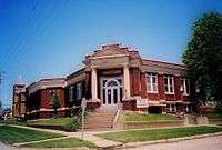
Macon Public Library | |
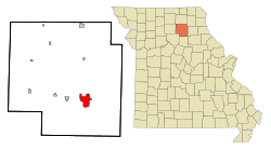 Location of Macon, Missouri | |
| Coordinates: 39°44′26″N 92°28′14″W / 39.74056°N 92.47056°WCoordinates: 39°44′26″N 92°28′14″W / 39.74056°N 92.47056°W | |
| Country | United States |
| State | Missouri |
| County | Macon |
| Government | |
| • Mayor | Dale Bagley (Democratic) |
| Area[1] | |
| • Total | 6.30 sq mi (16.32 km2) |
| • Land | 6.00 sq mi (15.54 km2) |
| • Water | 0.30 sq mi (0.78 km2) |
| Elevation | 869 ft (265 m) |
| Population (2010)[2] | |
| • Total | 5,471 |
| • Estimate (2012[3]) | 5,500 |
| • Density | 911.8/sq mi (352.0/km2) |
| Time zone | Central (CST) (UTC-6) |
| • Summer (DST) | CDT (UTC-5) |
| ZIP code | 63552 |
| Area code(s) | 660 |
| FIPS code | 29-45326[4] |
| GNIS feature ID | 0735708[5] |
Macon is a city in Macon County, Missouri, United States. The population was 5,500 at the 2012 census. It is the county seat of Macon County.[6]
History
Macon was platted in 1856.[7] Like the county, Macon was named for Nathaniel Macon.[8] A post office called Macon City was established in 1856, and the name was changed to Macon in 1892.[9]
President Barack Obama visited the POET LLC renewable energy plant in Macon on April 28, 2010 to promote his renewable energy policies. The plant which started operations in 2003 employs 45 people and produces 46 million gallons of ethanol a year from 16 million bushels of corn purchased from area farmers. It was the first biofuel refining plant in Missouri and claims to be the largest company by revenue in Northeast Missouri.[10][11]
Geography
Macon is located at 39°44′26″N 92°28′14″W / 39.74056°N 92.47056°W (39.740596, -92.470639).[12] According to the United States Census Bureau, the city has a total area of 6.30 square miles (16.32 km2), of which 6.00 square miles (15.54 km2) is land and 0.30 square miles (0.78 km2) is water.[1]
Demographics
| Historical population | |||
|---|---|---|---|
| Census | Pop. | %± | |
| 1860 | 837 | — | |
| 1870 | 3,678 | 339.4% | |
| 1880 | 3,046 | −17.2% | |
| 1890 | 3,371 | 10.7% | |
| 1900 | 4,068 | 20.7% | |
| 1910 | 3,584 | −11.9% | |
| 1920 | 3,549 | −1.0% | |
| 1930 | 3,851 | 8.5% | |
| 1940 | 4,206 | 9.2% | |
| 1950 | 4,152 | −1.3% | |
| 1960 | 4,547 | 9.5% | |
| 1970 | 5,301 | 16.6% | |
| 1980 | 5,680 | 7.1% | |
| 1990 | 5,571 | −1.9% | |
| 2000 | 5,538 | −0.6% | |
| 2010 | 5,471 | −1.2% | |
| Est. 2015 | 5,436 | [13] | −0.6% |
2010 census
As of the census[2] of 2010, there were 5,471 people, 2,369 households, and 1,357 families residing in the city. The population density was 911.8 inhabitants per square mile (352.0/km2). There were 2,727 housing units at an average density of 454.5 per square mile (175.5/km2). The racial makeup of the city was 90.8% White, 5.6% African American, 0.3% Native American, 0.6% Asian, 0.3% from other races, and 2.4% from two or more races. Hispanic or Latino of any race were 1.3% of the population.
There were 2,369 households of which 27.7% had children under the age of 18 living with them, 42.0% were married couples living together, 11.6% had a female householder with no husband present, 3.7% had a male householder with no wife present, and 42.7% were non-families. 38.1% of all households were made up of individuals and 18.5% had someone living alone who was 65 years of age or older. The average household size was 2.21 and the average family size was 2.90.
The median age in the city was 42.7 years. 23.2% of residents were under the age of 18; 7.4% were between the ages of 18 and 24; 21.7% were from 25 to 44; 25.1% were from 45 to 64; and 22.5% were 65 years of age or older. The gender makeup of the city was 46.7% male and 53.3% female.
2000 census
As of the census[4] of 2000, there were 5,538 people, 2,434 households, and 1,448 families residing in the city. The population density was 903.9 people per square mile (348.8/km²). There were 2,723 housing units at an average density of 444.4/sq mi (171.5/km²). The racial makeup of the city was 92.78% White, 5.36% African American, 0.22% Native American, 0.23% Asian, 0.02% Pacific Islander, 0.42% from other races, and 0.98% from two or more races. Hispanic or Latino of any race were 0.88% of the population.
There were 2,434 households out of which 27.2% had children under the age of 18 living with them, 46.1% were married couples living together, 10.5% had a female householder with no husband present, and 40.5% were non-families. 37.1% of all households were made up of individuals and 19.8% had someone living alone who was 65 years of age or older. The average household size was 2.17 and the average family size was 2.82.
In the city the population was spread out with 22.7% under the age of 18, 7.7% from 18 to 24, 24.1% from 25 to 44, 21.7% from 45 to 64, and 23.8% who were 65 years of age or older. The median age was 42 years. For every 100 females there were 85.8 males. For every 100 females age 18 and over, there were 79.3 males.
The median income for a household in the city was $26,738, and the median income for a family was $36,633. Males had a median income of $30,069 versus $18,217 for females. The per capita income for the city was $16,679. About 8.6% of families and 12.8% of the population were below the poverty line, including 11.4% of those under age 18 and 16.8% of those age 65 or over.
Media
- Macon city and county are served by one, the Home Press.
- Radio station KLTI is licensed to Macon. Other radio signals from cities in the region like Brookfield, Marceline, Kirksville, and Moberly are easily received in Macon as well.
Notable residents
- Frederick W. V. Blees, chief benefactor of Macon, founder of Blees Military Academy, (1860–1906).
- Frank P. Briggs, former United States Senator and Assistant U.S. Secretary of the Interior.
- Henderson Forsythe, (1916–2006), American Actor
- James P. Kem, United States Senator from Missouri, 1947-1953.
- Milton A. Romjue, long-time US Congressman for Missouri's 1st district.
- Butch Patrick, noted television actor best known from his role of Eddie Munster on CBS's The Munsters.
References
- 1 2 "US Gazetteer files 2010". United States Census Bureau. Retrieved 2012-07-08.
- 1 2 "American FactFinder". United States Census Bureau. Retrieved 2012-07-08.
- ↑ "Population Estimates". United States Census Bureau. Retrieved 2013-05-30.
- 1 2 "American FactFinder". United States Census Bureau. Retrieved 2008-01-31.
- ↑ "US Board on Geographic Names". United States Geological Survey. 2007-10-25. Retrieved 2008-01-31.
- ↑ "Find a County". National Association of Counties. Retrieved 2011-06-07.
- ↑ "Macon County Place Names, 1928–1945". The State Historical Society of Missouri. Archived from the original on June 24, 2016. Retrieved October 30, 2016.
- ↑ Eaton, David Wolfe (1916). How Missouri Counties, Towns and Streams Were Named. The State Historical Society of Missouri. p. 190.
- ↑ "Post Offices". Jim Forte Postal History. Retrieved 30 October 2016.
- ↑ http://www.stjoenews.net/news/2010/apr/28/obama-advocates-renewable-fuels-northern-missouri-/
- ↑ http://www.poet.com/inspiration/showPlant_Page.asp?id=42
- ↑ "US Gazetteer files: 2010, 2000, and 1990". United States Census Bureau. 2011-02-12. Retrieved 2011-04-23.
- ↑ "Annual Estimates of the Resident Population for Incorporated Places: April 1, 2010 to July 1, 2015". Retrieved July 2, 2016.
- ↑ "Census of Population and Housing". Census.gov. Retrieved June 4, 2015.
External links
- "1956 Macon Centennial photographs". University of Missouri–St. Louis.
- Historic maps of Macon in the Sanborn Maps of Missouri Collection at the University of Missouri
Municipalities and communities of Macon County, Missouri, United States | ||
|---|---|---|
| Cities |  | |
| Townships | ||
| CDP | ||
| Other unincorporated communities | ||
| Ghost towns | ||