Keytesville, Missouri
| Keytesville, Missouri | |
|---|---|
| City | |
 Location of Keytesville, Missouri | |
| Coordinates: 39°26′3″N 92°56′13″W / 39.43417°N 92.93694°WCoordinates: 39°26′3″N 92°56′13″W / 39.43417°N 92.93694°W | |
| Country | United States |
| State | Missouri |
| County | Chariton |
| Area[1] | |
| • Total | 0.78 sq mi (2.02 km2) |
| • Land | 0.77 sq mi (1.99 km2) |
| • Water | 0.01 sq mi (0.03 km2) |
| Elevation | 709 ft (216 m) |
| Population (2010)[2] | |
| • Total | 471 |
| • Estimate (2012[3]) | 458 |
| • Density | 611.7/sq mi (236.2/km2) |
| Time zone | Central (CST) (UTC-6) |
| • Summer (DST) | CDT (UTC-5) |
| ZIP code | 65261 |
| Area code(s) | 660 |
| FIPS code | 29-38468[4] |
| GNIS feature ID | 0720566[5] |
Keytesville is a town in Chariton County, Missouri, United States. The population was 471 at the 2010 census. It is the county seat of Chariton County.[6] Keytesville is the hometown of two notable American generals, Maxwell D. Taylor and Sterling Price.
History
The town is named for Englishman James Keyte, the town founder.[7] Keyte, a Methodist preacher, purchased a large parcel of land in 1830 and, two years later, donated fifty acres of it to Chariton County for the purpose of establishing a centralized seat of county government.[8] Prior to that time, the county business had been conducted from "Old Chariton," a small village near the confluence of the Chariton and Missouri Rivers. However, incessant disease-spreading mosquitoes and repeated river flooding necessitated a new location.[9]
The first courthouse was constructed in Keytesville between 1833 and 1834. As a two-story, four-room brick building, it survived until September 20, 1864, when it was burned down by the Confederate raiders during the American Civil War.[9] James Keyte constructed the first home in Keytesville, and the first business as well. Both were log structures, with the second doubling as a post office. Keyte is also responsible for the town's first industry of any sort, when he constructed a mill near his home on Muscle Fork Creek.[8] Isaac Redding added a Keytesville's first hotel in August 1842. Keytesville was incorporated on February 3, 1868, by the state of Missouri, and incorporated as a Missouri 4th class city in March 1883.[8]
Confederate raid
One of Keytesville's native sons, Sterling Price, was a key figure in Missouri during the Civil War, and violence would be visited on the community as well. As mentioned above, on September 20, 1864, a Confederate force of 250 men—among them George Todd and other members of Quantrill's Raiders [10]—under Major John Thrailkill arrived at the edge of town. This was part of General Price's larger 1864 campaign through the Show Me state, as his forces advanced from eastern Missouri to the Kansas City area along the Missouri river. At the time, Thrailkill's force arrived Keytesville was defended by a small Union detachment of thirty-five men from the Missouri militia, commanded by Lieutenant Anthony Pleyer.[11] Early on the morning of September 20, under a flag of truce, Major Thrailkill demanded the surrender of the Union troops, promising fair treatment. Seeing the situation as hopeless, Pleyer complied. Rather than being taken prisoner, the Union garrison was paroled. Confederate forces then briefly occupied the town, liberating supplies from various merchants, setting the courthouse ablaze and killing two citizens—Chariton County sheriff Robert Carmon and William Young, a Union scout and alleged spy.[12]
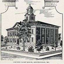
A second courthouse was built not long after the Civil War concluded. In February 1866, a contract was awarded for construction of a two-story brick building with cupola. It was built at a cost of $40,000, and served the county until 1973.[13] By the mid-1890s, Keytesville had an estimated population of around 1,100 citizens. Two newspapers, the Chariton Courier and Keytesville Signal, served the community. Business and industry at that time consisted of Keytesville Roller Mill, a large water-powered grist mill on Muscle Fork Creek, two banks, a building and loan association, two hotels, a distillery, general mercantiles, restaurants, and sundry other businesses.[8][9] Due to its location 1.5 mi (2.4 km) north of the Wabash Railroad line, the merchants of Keytesville needed a reliable and convenient way to attract potential customers. This led, in 1889, to the construction of a streetcar line, something one would only expect in much larger cities. Hugo Bartz and J. J. Moore, two prominent citizens of the time, secured land and financing for the project, which when completed consisted of two miles of track, and a large barn for horses and rolling stock, constructed for a cost of $10,000.[8] Two horse-drawn passenger coaches and a large flatcar for freight delivered new arrivals at the Wabash depot to the town.
Keytesville today
While small, the town does have an active business district and chamber of commerce. Included are a swimming pool, insurance sales, bank, convenience store, law offices, chiropractor, restaurant, auto repair, agricultural services and medical clinic.[9] The town has various service clubs and organizations, including the Lions Club. There are three sites in Keytesville listed on the National Register of Historic Places: the First Presbyterian Church, the Chariton County Jail and Sheriff's Residence, and the Redding-Hill House. A new Chariton County Courthouse was constructed in Keytesville in the summer of 1974 and occupied the following July. This was made necessary due to a fire that destroyed the previous Chariton County Courthouse on August 27, 1973.[13]
Government
Keytesville, a Missouri 4th class city, governs by a mayor-council system. Voters elect two aldermen from two wards, each serving a two-year term, and a mayor at-large, also for a two-year term.[9] The Keytesville Fire District, a volunteer force, provides fire protection for the town and surrounding rural area. law enforcement duties are handled by the Chariton County Sheriff's Department. The department headquarters and county jail are located in Keytesville. The city of Keytesville operates two parks. One of the parks provides camping opportunities with full hookup available.
Education

Keytesville R-III School district serves the town of Keytesville and surrounding rural area. Education in the community dates to before the Civil War, but many records indicating the exact date were lost in an 1861 fire at the county clerk's office.[14] In 1889, what might be considered the first modern-style school, a large 2-story building, was erected at a cost of $13,000[15] By 1909, Keytesville school was rated a first-class school by the state of Missouri. In 1949, a large number of the rural schools were combined with Keytesville to form the current district.[14] The current high school was constructed in 1959, with the current elementary school added in 1967. In 2010, the district had a total of 153 students K-12, and a graduation rate of 90-percent.[16] The school mascot is the Tiger and school colors are black and gold. Keytesville competes athletically in the Central Activities Conference. Its enrollment places the Tigers in Class 1 under Missouri State High School Activities Association guidelines.
Geography
Keytesville is located on the Lewis and Clark Trail, now U.S. Route 24. It is 10 mi (16 km) east of Brunswick and 30 mi (48 km) west of Moberly. Keytesville is located at 39°26′3″N 92°56′13″W / 39.43417°N 92.93694°W (39.434144, -92.936967).[17] According to the United States Census Bureau, the city has a total area of 0.78 square miles (2.02 km2), of which, 0.77 square miles (1.99 km2) is land and 0.01 square miles (0.03 km2) is water.[1]
Demographics
| Historical population | |||
|---|---|---|---|
| Census | Pop. | %± | |
| 1870 | 529 | — | |
| 1880 | 737 | 39.3% | |
| 1890 | 819 | 11.1% | |
| 1900 | 1,127 | 37.6% | |
| 1910 | 963 | −14.6% | |
| 1920 | 872 | −9.4% | |
| 1930 | 738 | −15.4% | |
| 1940 | 854 | 15.7% | |
| 1950 | 733 | −14.2% | |
| 1960 | 644 | −12.1% | |
| 1970 | 730 | 13.4% | |
| 1980 | 689 | −5.6% | |
| 1990 | 564 | −18.1% | |
| 2000 | 533 | −5.5% | |
| 2010 | 471 | −11.6% | |
| Est. 2015 | 455 | [18] | −3.4% |
2010 census
As of the census[2] of 2010, there were 471 people, 225 households, and 124 families residing in the city. The population density was 611.7 inhabitants per square mile (236.2/km2). There were 275 housing units at an average density of 357.1 per square mile (137.9/km2). The racial makeup of the city was 98.5% White, 0.6% African American, 0.4% Native American, and 0.4% Asian.
There were 225 households of which 20.0% had children under the age of 18 living with them, 42.2% were married couples living together, 7.6% had a female householder with no husband present, 5.3% had a male householder with no wife present, and 44.9% were non-families. 40.0% of all households were made up of individuals and 16.4% had someone living alone who was 65 years of age or older. The average household size was 2.07 and the average family size was 2.71.
The median age in the city was 46.4 years. 17.8% of residents were under the age of 18; 8.6% were between the ages of 18 and 24; 21.2% were from 25 to 44; 31.5% were from 45 to 64; and 21% were 65 years of age or older. The gender makeup of the city was 49.7% male and 50.3% female.
2000 census
As of the census[4] of 2000, there were 533 people, 253 households, and 129 families residing in the city. The population density was 764.8 people per square mile (294.0/km²). There were 295 housing units at an average density of 423.3 per square mile (162.7/km²). The racial makeup of the city was 95.31% White, 3.94% African American, 0.19% from other races, and 0.56% from two or more races. Hispanic or Latino of any race were 0.19% of the population.
There were 253 households out of which 22.5% had children under the age of 18 living with them, 40.7% were married couples living together, 7.1% had a female householder with no husband present, and 49.0% were non-families. 45.5% of all households were made up of individuals and 27.7% had someone living alone who was 65 years of age or older. The average household size was 2.07 and the average family size was 2.96.
In the city the population was spread out with 21.8% under the age of 18, 7.3% from 18 to 24, 23.3% from 25 to 44, 21.4% from 45 to 64, and 26.3% who were 65 years of age or older. The median age was 44 years. For every 100 females there were 88.3 males. For every 100 females age 18 and over, there were 80.5 males.
The median income for a household in the city was $25,000, and the median income for a family was $35,568. Males had a median income of $25,156 versus $16,071 for females. The per capita income for the city was $14,699. About 10.9% of families and 16.4% of the population were below the poverty line, including 12.4% of those under age 18 and 17.0% of those age 65 or over.
Notable people from Keytesville
- Jane Hadley Barkley, former 2nd Lady of the U.S., wife of Alben Barkley
- Cal Hubbard, member of both the Pro Football Hall of Fame and Major League Baseball Hall of Fame
- Sterling Price, former Missouri governor and Confederate general
- Maxwell D. Taylor, former U.S. Army general and diplomat
19th-century Keytesville
 A portion of the Keytesville business district in 1896
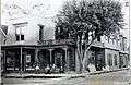 Sneed's Hotel, Keytesville, 1896
 Big Spring Distillery,Keytesville, Missouri. Makers of "Old Chariton Rye" and "Ole Kentuck" whiskey, 1896
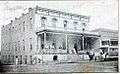 Hotel Snyder, Keytesville. Note the horse-drawn streetcar in the right corner, part of Keytesville's streetcar rail system.
References
- 1 2 "US Gazetteer files 2010". United States Census Bureau. Retrieved 2012-07-08.
- 1 2 "American FactFinder". United States Census Bureau. Retrieved 2012-07-08.
- ↑ "Population Estimates". United States Census Bureau. Retrieved 2013-05-30.
- 1 2 "American FactFinder". United States Census Bureau. Retrieved 2008-01-31.
- ↑ "US Board on Geographic Names". United States Geological Survey. 2007-10-25. Retrieved 2008-01-31.
- ↑ "Find a County". National Association of Counties. Retrieved 2011-06-07.
- ↑ "Disappearing Missouri Names". The Kansas City Star. March 19, 1911. p. 15. Retrieved August 15, 2014 – via Newspapers.com.

- 1 2 3 4 5 Historical, Pictorial, & Biographical Record of Chariton County, Missouri, Pictorial and Biographical Publishing Co., Salisbury Missouri, 1896
- 1 2 3 4 5 "History of the city of Keytesville". Keytesville Area Chamber of Commerce. 2011. Retrieved 5 August 2012.
- ↑ Castel, Albert E. with TH Goodrich, Bloody Bill Anderson: The Short Savage Life of a Civil War Guerrilla, Stackpole Books, 1998. pg. 60
- ↑ The War of the Rebellion: A compilation of the official records of the Union Army., Written and published by the United States War Department. pp. 427-430
- ↑ Lause, Mark A., Prices Lost Campaign: The 1864 Invasion of Missouri, University of Missouri Press, 2011, pg. 60
- 1 2 "Chariton County Courthouse profile". University of Missouri Extension. 2011. Retrieved 5 August 2012.
- 1 2 "Keytesville School History". Keytesville R-III website. 2011. Retrieved 5 August 2012.
- ↑ Chariton Courier, 29 May 1896.
- ↑ "Chariton County school districts data" (PDF). Keytesville Chamber of Commerce. 2011. Retrieved 5 August 2012.
- ↑ "US Gazetteer files: 2010, 2000, and 1990". United States Census Bureau. 2011-02-12. Retrieved 2011-04-23.
- ↑ "Annual Estimates of the Resident Population for Incorporated Places: April 1, 2010 to July 1, 2015". Retrieved July 2, 2016.
- ↑ "Census of Population and Housing". Census.gov. Retrieved June 4, 2015.
External links
- Historic maps of Keytesville in the Sanborn Maps of Missouri Collection at the University of Missouri
Municipalities and communities of Chariton County, Missouri, United States | ||
|---|---|---|
| Cities | 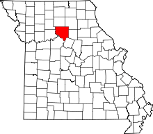 | |
| Villages | ||
| Townships | ||
| Unincorporated communities | ||
| Footnotes | ‡This populated place also has portions in an adjacent county or counties | |