Washington County, Kentucky
| Washington County, Kentucky | |
|---|---|
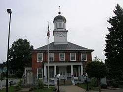 Washington County courthouse in Springfield | |
 Location in the U.S. state of Kentucky | |
 Kentucky's location in the U.S. | |
| Founded | 1792 |
| Named for | George Washington |
| Seat | Springfield |
| Largest city | Springfield |
| Area | |
| • Total | 301 sq mi (780 km2) |
| • Land | 297 sq mi (769 km2) |
| • Water | 3.9 sq mi (10 km2), 1.3% |
| Population | |
| • (2010) | 11,717 |
| • Density | 39/sq mi (15/km²) |
| Congressional districts | 1st, 2nd |
| Time zone | Eastern: UTC-5/-4 |
| Website |
www |
Washington County is a county located in the U.S. state of Kentucky. As of the 2010 census, the population was 11,717.[1] Its county seat is Springfield.[2] The county is named for George Washington.[3]
Washington County was the first county formed in the Commonwealth of Kentucky when it reached statehood, and the sixteenth county formed.[4] The center of population of Kentucky is located in Washington County, in the city of Willisburg.[5]
The county is dry, meaning that the sale of alcohol is prohibited, but it contains the "wet" city of Springfield, where retail alcohol sales are allowed. This classifies the jurisdiction as a moist county. Three wineries operate in the county and are licensed separately to sell to the public.[6] Jacob Beam, founder of Jim Beam whiskey, sold his first barrel of whiskey in Washington County.[7]
History
Washington County was established in 1792 from land given by Nelson County. It was the first county created by the Commonwealth of Kentucky after its separation from Virginia.[8]
The Washington County Courthouse, completed in 1816, is the oldest courthouse still in use in Kentucky.[9] A significant county court record is the marriage bond of Thomas Lincoln and Nancy Hanks, parents of President Abraham Lincoln.[10] The bond is dated June 10, 1806; it was written the day before the marriage in the small community of Beechland on the Little Beech River. The marriage return was signed by Jesse Head, the Methodist preacher who performed the ceremony, and dates the marriage to June 12, 1806.
Geography
According to the U.S. Census Bureau, the county has a total area of 301 square miles (780 km2), of which 297 square miles (770 km2) is land and 3.9 square miles (10 km2) (1.3%) is water.[11]
Adjacent counties
- Anderson County - northeast
- Mercer County - east
- Boyle County - east
- Marion County - south
- Nelson County - west
Demographics
| Historical population | |||
|---|---|---|---|
| Census | Pop. | %± | |
| 1800 | 9,050 | — | |
| 1810 | 13,248 | 46.4% | |
| 1820 | 15,947 | 20.4% | |
| 1830 | 19,017 | 19.3% | |
| 1840 | 10,596 | −44.3% | |
| 1850 | 12,194 | 15.1% | |
| 1860 | 11,575 | −5.1% | |
| 1870 | 12,464 | 7.7% | |
| 1880 | 14,419 | 15.7% | |
| 1890 | 13,622 | −5.5% | |
| 1900 | 14,182 | 4.1% | |
| 1910 | 13,940 | −1.7% | |
| 1920 | 14,773 | 6.0% | |
| 1930 | 12,623 | −14.6% | |
| 1940 | 12,965 | 2.7% | |
| 1950 | 12,777 | −1.5% | |
| 1960 | 11,168 | −12.6% | |
| 1970 | 10,728 | −3.9% | |
| 1980 | 10,764 | 0.3% | |
| 1990 | 10,441 | −3.0% | |
| 2000 | 10,916 | 4.5% | |
| 2010 | 11,717 | 7.3% | |
| Est. 2015 | 12,063 | [12] | 3.0% |
| U.S. Decennial Census[13] 1790-1960[14] 1900-1990[15] 1990-2000[16] 2010-2013[1] | |||
As of the census[17] of 2000, there were 10,916 people, 4,121 households, and 3,020 families residing in the county. The population density was 36 per square mile (14/km2). There were 4,542 housing units at an average density of 15 per square mile (5.8/km2). The racial makeup of the county was 90.62% White, 7.51% Black or African American, 0.16% Native American, 0.28% Asian, 0.61% from other races, and 0.82% from two or more races. 1.60% of the population were Hispanic or Latino of any race.
There were 4,121 households out of which 33.10% had children under the age of 18 living with them, 59.50% were married couples living together, 10.00% had a female householder with no husband present, and 26.70% were non-families. 24.00% of all households were made up of individuals and 11.40% had someone living alone who was 65 years of age or older. The average household size was 2.57 and the average family size was 3.03.
The age distribution was 25.30% under the age of 18, 8.80% from 18 to 24, 27.90% from 25 to 44, 23.10% from 45 to 64, and 15.00% who were 65 years of age or older. The median age was 37 years. For every 100 females there were 96.60 males. For every 100 females age 18 and over, there were 91.90 males.
The median income for a household in the county was $33,136, and the median income for a family was $39,240. Males had a median income of $27,624 versus $21,593 for females. The per capita income for the county was $15,722. About 10.30% of families and 13.50% of the population were below the poverty line, including 14.40% of those under age 18 and 19.60% of those age 65 or over.
Education
The county is served by Washington County Schools, a district that contains five schools:[18]
- North Washington Elementary School in Willisburg for grades PK, K-8 with 468 students
- Washington County Elementary School in Springfield for grades PK, K-5 with 387 students
- Care Academy, Inc. in Willisburg for grades 6-12 with 65 students
- Washington County Middle School in Springfield for grades 6-8 with 206 students
- Washington County High School in Springfield for grades 9-12 with 626 students
St. Catharine College is located near Springfield.
Communities
- Bear Wallow
- Brush Grove
- Fredericktown
- Mackville
- Manton
- Pleasant Grove
- Saint Catharine
- Springfield (county seat)
- Thompsonville
- Willisburg
See also
References
- 1 2 "State & County QuickFacts". United States Census Bureau. Retrieved March 6, 2014.
- ↑ "Find a County". National Association of Counties. Retrieved 2011-06-07.
- ↑ The Register of the Kentucky State Historical Society, Volume 1. Kentucky State Historical Society. 1903. p. 37.
- ↑ "Springfield, Kentucky and Washington County". KyHomeTown.com. Retrieved 2009-05-08.
- ↑ "Population and Population Centers by State: 2000". US Census Bureau. Retrieved 2009-05-08.
- ↑ "Wet & Dry Counties in Kentucky" (PDF). Kentucky Office of Alcoholic Beverage Control. Archived from the original (PDF) on March 15, 2007. Retrieved March 21, 2007.
- ↑ "Review: Jim Beam", Alternative Whisky Academy
- ↑ Collins, Lewis (1882). Collins' Historical Sketches of Kentucky: History of Kentucky, Volume 2. Collins & Company. p. 26.
- ↑ Day, Teresa (Jan 30, 2005). Fun With the Family Kentucky: Hundreds of Ideas for Day Trips with the Kids. Globe Pequot. p. 41. Retrieved 2013-05-07.
- ↑ "Springfield, Kentucky". The City of Springfield, KY. Retrieved 2009-05-08.
- ↑ "2010 Census Gazetteer Files". United States Census Bureau. August 22, 2012. Retrieved August 20, 2014.
- ↑ "County Totals Dataset: Population, Population Change and Estimated Components of Population Change: April 1, 2010 to July 1, 2015". Retrieved July 2, 2016.
- ↑ "U.S. Decennial Census". United States Census Bureau. Retrieved August 20, 2014.
- ↑ "Historical Census Browser". University of Virginia Library. Retrieved August 20, 2014.
- ↑ "Population of Counties by Decennial Census: 1900 to 1990". United States Census Bureau. Retrieved August 20, 2014.
- ↑ "Census 2000 PHC-T-4. Ranking Tables for Counties: 1990 and 2000" (PDF). United States Census Bureau. Retrieved August 20, 2014.
- ↑ "American FactFinder". United States Census Bureau. Retrieved 2008-01-31.
- ↑ "Washington County School District". education.com. Retrieved 2009-05-31.
Coordinates: 37°45′N 85°10′W / 37.75°N 85.17°W
Municipalities and communities of Washington County, Kentucky, United States | ||
|---|---|---|
| Cities | | |
| Unincorporated communities | ||
